Cambridgeshire is a county in the East of England, bordering Lincolnshire to the north, Norfolk to the north-east, Suffolk to the east, Essex and Hertfordshire to the south, and Bedfordshire and Northamptonshire to the west. The city of Cambridge is the county town. Following the Local Government Act 1972 restructuring, modern Cambridgeshire was formed in 1974 through the amalgamation of two administrative counties: Cambridgeshire and Isle of Ely, comprising the historic county of Cambridgeshire ; and Huntingdon and Peterborough, comprising the historic county of Huntingdonshire and the Soke of Peterborough, historically part of Northamptonshire. Cambridgeshire contains most of the region known as Silicon Fen.

The Fens, also known as the Fenlands, in eastern England are a naturally marshy region supporting a rich ecology and numerous species. Most of the fens were drained centuries ago, resulting in a flat, dry, low-lying agricultural region supported by a system of drainage channels and man-made rivers and automated pumping stations. There have been unintended consequences to this reclamation, as the land level has continued to sink and the dykes have been built higher to protect it from flooding.

Wisbech is a market town, inland port and civil parish in the Fenland district in Cambridgeshire, England. In 2011 it had a population of 31,573. The town lies in the far north-east of Cambridgeshire, bordering Norfolk and only 5 miles (8 km) south of Lincolnshire. The tidal River Nene running through the town is spanned by two road bridges. Wisbech is in the Isle of Ely and has been described as 'the Capital of The Fens".
Burwell is a village and civil parish in Cambridgeshire, England, some 10 miles north-east of Cambridge. It lies on the south-east edge of the Fens. Westward drainage is improved by Cambridgeshire lodes (waterways), including Burwell Lode, a growth factor in the village. A population of 6,309 in the 2011 census was put at 6,417 in 2019.

Soham is a town and civil parish in the district of East Cambridgeshire, in Cambridgeshire, England, just off the A142 between Ely and Newmarket. Its population was 10,860 at the 2011 census.

Ramsey is a market town and civil parish in the Huntingdonshire district of Cambridgeshire, England. The town is about 9 miles (14 km) north of Huntingdon. Ramsey parish includes the settlements of Ramsey Forty Foot, Ramsey Heights, Ramsey Mereside, Ramsey Hollow and Ramsey St Mary's.

Chatteris is a market town and civil parish in the Fenland district of Cambridgeshire, England, situated in The Fens between Huntingdon, March and Ely. The town is in the North East Cambridgeshire parliamentary constituency.

The post mill is the earliest type of European windmill. Its defining feature is that the whole body of the mill that houses the machinery is mounted on a single vertical post, around which it can be turned to bring the sails into the wind. All post mills have an arm projecting from them on the side opposite the sails and reaching down to near ground level. With some, as at Saxtead Green, the arm carries a fantail to turn the mill automatically. With the others the arm serves to rotate the mill into the wind by hand.
Wicken is a small village on the edge of The Fens near Soham in East Cambridgeshire, ten miles north east of Cambridge and five miles south of Ely. It is the site of Wicken Fen National Nature Reserve.

Swaffham Prior is a small village in East Cambridgeshire, England.
Wicken Fen is a 254.5 hectare biological Site of Special Scientific Interest west of Wicken in Cambridgeshire. It is also a National Nature Reserve, and a Nature Conservation Review site. It is protected by international designations as a Ramsar wetland site of international importance, and part of the Fenland Special Area of Conservation under the Habitats Directive.

Ullesthorpe is a small village and civil parish situated in the Harborough district in southern Leicestershire. Ullesthorpe is noted for its historic background with a mill, disused railway station and traces of a medieval settlement evident on the edge of the village.

Thorney is a village in the Peterborough unitary authority in the ceremonial county of Cambridgeshire, England. Located around eight miles (13 km) east of Peterborough city centre, on the A47.

Stretham is a village and civil parish 4 miles (6 km) south-south-west of Ely in Cambridgeshire, England, about 74 miles (119 km) by road from London. Its main attraction is Stretham Old Engine, a steam-powered pump used to drain the fens. The pump is still in use today although converted to electric power. It has open days throughout the year.

The Wisbech & Fenland Museum, located in the town of Wisbech in the Isle of Ely, Cambridgeshire, England, is one of the oldest purpose-built museums in the United Kingdom. The museum logo is W&F.

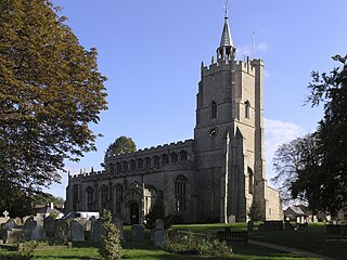
Little Thetford is a small village in the civil parish of Thetford, 3 miles (5 km) south of Ely in Cambridgeshire, England, about 76 miles (122 km) by road from London. The village is built on a boulder clay island surrounded by flat fenland countryside, typical of settlements in this part of the East of England. During the Mesolithic era, the fenland basin was mostly dry and forested, although subject to salt and fresh water incursions. The marshes and meres of this fenland may therefore have been difficult to occupy, other than seasonally, but there is evidence of human settlement on the island since the late Neolithic Age; a Bronze Age causeway linked the village with the nearby Barway, to the south-east. An investigation, prior to a 1995 development in the village, discovered a farm and large tile-kiln of Romano-British origin; further investigations uncovered an earlier settlement of the Pre-Roman Iron Age. The Roman road Akeman Street passed through the north-west corner of the parish, and the lost 7th century Anglo-Saxon village of Cratendune may be nearby.

The Cambridgeshire Lodes are a series of man-made waterways, believed to be Roman in origin, located in the county of Cambridgeshire, England. Bottisham, Swaffham Bulbeck, Reach, Burwell, Wicken and Monks Lodes all connect to the River Cam, while Soham Lode connects to the River Great Ouse. All have been navigable historically, but some are no longer officially navigable.

Ely is a cathedral city in the East Cambridgeshire district of Cambridgeshire, England, about 14 miles (23 km) north-northeast of Cambridge and 80 miles (130 km) from London.

Burwell Castle was an unfinished medieval enclosure castle in Burwell, Cambridgeshire, England.

