Related Research Articles

The Lane Cove National Park is a protected national park that is located within metropolitan Sydney, in New South Wales, Australia. The 670-hectare (1,700-acre) national park is situated about 10 kilometres (6.2 mi) north-west of the Sydney central business district and features various vegetation types, such as, wet and dry sclerophyll forest, heathland, mangroves and tidal flats. The park consists of land near the banks of the Lane Cove River, which flows generally south-east into Sydney Harbour. It also extends to the outskirts of Pennant Hills and Wahroonga at its northern boundaries.

In Australia, bushland is a blanket term for land which supports remnant vegetation or land which is disturbed but still retains a predominance of the original floristics and structure.
Bush regeneration, a form of natural area restoration, is the term used in Australia for the ecological restoration of remnant vegetation areas, such as through the minimisation of negative disturbances, both exogenous such as exotic weeds and endogenous such as erosion. It may also attempt to recreate conditions of pre-European arrival, for example by simulating endogenous disturbances such as fire. Bush regeneration attempts to protect and enhance the floral biodiversity in an area by providing conditions conducive to the recruitment and survival of native plants.
Greening Australia is an Australian environmental organisation, founded in 1982, the International Year of the Tree, to protect, restore and conserve Australia's native vegetation. Greening Australia was formed by the United Nations Association of Australia and the Nursery Industry Association of Australia.

Bulimba Creek, originally known as Doboy Creek or Doughboy Creek, is a perennial stream that is a tributary of the Brisbane River, located in suburban Brisbane in the South East region of Queensland, Australia.
Puckey's Estate Reserve is a coastal nature reserve in North Wollongong, New South Wales, Australia. It is mainly she-oak forest, but also has sand dune and wetland areas, including areas along Para Creek. It is located in the suburb of Fairy Meadow and is bounded by Fairy Meadow Beach to the east, Squires Way to the west, Elliotts Road to the north and Fairy Lagoon to the south.
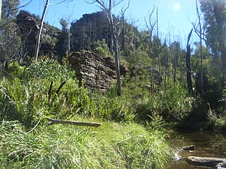
The bushland in Michael Eades Reserve and surrounds is rich in sensitive vegetation, unique to the upper Blue Mountains plateau, in New South Wales, Australia. Many of the significant plants in the area, such as Acacia ptychoclada and Grevillea acanthifolia, do not appear anywhere else in the world.

Mount Henry Peninsula is a land feature and reserve located 11 km (6.8 mi) south of Perth, Western Australia, on the north bank of the Canning River near the Mount Henry Bridge in Salter Point, Western Australia. It covers 11.9 hectares, and includes both Banksia attenuata and Banksia menziesii woodland, and a muddy and desert biome. The peninsula features limestone slopes, shoreline vegetation, wetlands, and contains the most inland vegetated knoll of the Spearwood dunes on the Swan-Canning estuary, as well as a significant variety of natural conditions for birds and other fauna. The Mount Henry Peninisula is a designated Bush Forever Site, number 227.
The Conservation Council of Western Australia is the umbrella body for conservation groups and organisations in Western Australia. It has been the co-ordinator, publisher and guiding body for issues of woodchipping in the South West of Western Australia, the logging of old growth forests, as well as providing input into government processes involved with all aspects of environmental protection and conservation.

The Sydney Turpentine-Ironbark Forest (STIF) is a wet sclerophyll forest community of Sydney, New South Wales, Australia, that is typically found in the Inner West and Northern region of Sydney. It is also among the three of these plant communities which have been classified as Endangered, under the New South Wales government's Threatened Species Conservation Act 1995, with only around 0.5% of its original pre-settlement range remaining.
The Centenary Suburbs are a group of suburbs in the south-west in the City of Brisbane, Queensland, Australia. The suburbs originated as an "ambitious long-term suburban development proposal that included a number of neighbourhoods, or suburbs, each with sufficient services and facilities for its residents to have their day-to-day needs met without having to go elsewhere".
George Kendall Riverside Park is a 27.2-hectare (67-acre) recreational park in Ermington, New South Wales, on the northern bank of the Parramatta River.

Yarran Dheran Nature Reserve is a nature reserve and bushland park that forms part of the Mullum Mullum Valley. It is located on the banks of the Mullum Mullum Creek, on the border of Donvale in Melbourne. The reserve spans 7.2 hectares and features a mix of remnant and regenerated bushland, supporting a variety of native wildlife, particularly birds, with 85 species observed. The Mullum Mullum Creek Trail passes through the reserve, which also contains numerous unsealed bush tracks. An information centre, open on Sunday afternoons from 2:00 pm to 4:00 pm, provides visitor information. The reserve includes a series of ponds that feed into a cascade leading to the creek during wet periods. Amenities include toilets, mown areas for picnics, and seating. Yarran Dheran is a dogs-on-lead reserve.

The Wolli Creek Regional Park is a 50 hectares regional park, located adjacent to Wolli Creek within the Wolli Creek Valley, between Bexley North and Tempe in south-west Sydney, New South Wales, Australia.

Bonogin is a rural hinterland locality in the City of Gold Coast, Queensland, Australia. In the 2021 census, Bonogin had a population of 4,896 people.
Woorabinda Bushland Reserves, formerly known as the Stirling Linear Park, is a 34 ha network of four parks and reserves located in the suburbs of Stirling and Heathfield in the Mount Lofty Ranges, South Australia. The parks are part of the Aldgate Creek catchment which feeds into the Onkaparinga River. 4 km of walking trails connect Stirling Park and Woorabinda to Madurta and Hender Reserves, all of which are open to the general public. The parks contain notable natural and early European heritage value and a network of interpretive signage provides information to park visitors.

Caravan Head Bushland Reserve is a reserve approximately 2.2ha located in Sutherland Shire, southern Sydney, in the state of New South Wales, Australia.

Prospect Nature Reserve is a nature reserve and recreational area that is situated in the western suburbs of Sydney, New South Wales, Australia, which incorporates the Prospect Reservoir, and also features picnic spots, lookouts, walking tracks and BBQ areas within the Australian bush. It is located within the Blacktown City local government area, but is also close to the boundaries of Cumberland Council and the City of Fairfield.
Waratah Park is a heritage-listed former Aboriginal land and fauna sanctuary and now Aboriginal title claim at 13 Namba Road, Duffys Forest in the Northern Beaches Council local government area of New South Wales, Australia. It is also known for serving as the fictional Waratah National Park, the filming location for the Australian television series Skippy the Bush Kangaroo, when the area was still undeveloped Crown land. After the series ended, the Crown land remained mostly undeveloped, with the government granting management of the area to a series of operators until August 2014, when the government passed full ownership of the land to the Metropolitan Local Aboriginal Land Council. It was added to the New South Wales State Heritage Register on 27 February 2015.

Trees For Life is a registered charity that protects and restores land in the bush, farms, and urban areas of South Australia. It runs many programs, the oldest involving volunteers growing seeds into small plants for planting by farmers and other landholders. It was formed in 1981 and now has 2000 volunteers.