
Wawarsing is a town in Ulster County, New York, United States. The population was 13,157 at the 2010 census. The name Wawarsing was once believed to mean "a place where the streams wind" in the Lenape language, referring to the geography in the hamlet of Wawarsing. Specifically, the joining of the Ver Nooy Kill and the Rondout Creek at Port Ben. The name Wawarsing was used by the Lenape to designate the current hamlet and the fields to the north and south of it for at least six miles in both directions. It is the only Lenape name known to refer to an exact location in Ulster County.

Hinckley and Bosworth is a local government district with borough status in south-western Leicestershire, England, administered by Hinckley and Bosworth Borough Council. Its only towns are Hinckley, Earl Shilton and Market Bosworth. Villages include Barwell, Burbage, Stoke Golding, Groby, Shackerstone and Twycross. The population of the Borough at the 2011 census was 105,078.

Tower Hamlets Cemetery Park is a local nature reserve and historic cemetery in the London Borough of Tower Hamlets within the East End of London. It is regarded as one of the seven great cemeteries of the time.
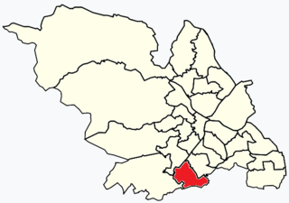
Beauchief and Greenhill ward—which includes the districts of Batemoor, Beauchief, Chancet Wood, Greenhill, Jordanthorpe, Lowedges and Meadow Head—is one of the 28 electoral wards in the City of Sheffield, England. It is in the southern part of the city and covers an area of 2.4 square miles (6.2 km2). The population of the ward in 2016 was estimated to be 19,669 people in 9,209 houses.
Lapworth is a village and civil parish in Warwickshire, England, which had a population of 2,100 according to the 2001 census; this had fallen to 1,828 at the 2011 Census. It lies six miles (10 km) south of Solihull and ten miles (16 km) northwest of Warwick, and incorporates the hamlet of Kingswood.

Chartham is a village and civil parish in the Canterbury district of Kent, England. It is situated on the Ashford side of the city, and is in the North Downs area of Outstanding Natural Beauty, 2.3 mi (4 km) south west of Canterbury, England. The Great Stour Way path passes through the village. A paper mill in the village has specialised in the production of tracing paper since 1938. There are numerous arable farms and orchards in the parish. The village has an unmanned station, Chartham, and a manned level crossing. It has an outlying locality sharing in many of the community resources, Chartham Hatch.

Broomhall is a civil parish in the unitary authority of Cheshire East and the ceremonial county of Cheshire, England. The main line of the Shropshire Union Canal runs through the parish and the River Weaver forms part of its boundary. The main settlement is the hamlet of Broomhall Green, which lies on the A530 about 3.5 miles (5.6 km) south-west of Nantwich. The civil parish has an area of 539 hectares, and also includes part of the small settlement of Sandford, with a total population of around 200 in 2011. Nearby villages include Aston, Sound, Wrenbury and Audlem. Broomhall appears in the Domesday survey and the name was also historically spelled Bromhall.
New York State Route 52 (NY 52) is a 108.72-mile-long (174.97 km) state highway in the southeastern part of the state. It generally runs from west to east through five counties, beginning at the Pennsylvania state line in the Delaware River near Narrowsburg, crossing the Hudson River on the Newburgh–Beacon Bridge, and ending in Carmel. NY 52 and NY 55, both major east–west routes of the Mid-Hudson Region, run parallel to each other, intersecting in downtown Liberty.

Arleston is a hamlet in the South Derbyshire district of Derbyshire, England, about 4 miles (6.4 km) south of the centre of Derby. It is located 1.2 miles (1.9 km) northwest of Barrow upon Trent and is part of that village's civil parish. The Trent and Mersey Canal passes through Arleston.

Wyville is a village in the civil parish of Wyville cum Hungerton, in the South Kesteven district of Lincolnshire, England, and situated approximately 5 miles (8 km) south-west from Grantham The whole parish covers about 1,670 acres (6.8 km2). The population is included in the civil parish of Little Ponton and Stroxton.
Kingsweston was a ward of the city of Bristol. The three districts in the ward wer Coombe Dingle, Lawrence Weston and Sea Mills. The ward takes its name from the old district of Kings Weston, now generally considered part of Lawrence Weston. Following a Local Government Boundary Commission review in 2015 ward boundaries were redrawn and Kingsweston ward is now split between the Stoke Bishop ward and the Avonmouth and Lawrence Weston ward.

The A1082 is an English A road entirely in the county of Norfolk. It runs from a junction with the A148 King's Lynn to Cromer Road to a roundabout on the A149 in the North Norfolk coastal town of Sheringham.
Colwich is a civil parish and village in Staffordshire, England. It is situated off the A51 road, about 3 miles (5 km) north west of Rugeley, and 7 miles (11 km) south east of Stafford. It lies principally on the north east bank of the River Trent near Wolseley Bridge, just north of The Chase. The parish comprises about 2,862 hectares (28.62 km2) of land in the villages and hamlets of Colwich, Great Haywood, Little Haywood, Moreton, Bishton, and Wolseley Bridge.

Swanley is a hamlet at SJ618523 in the unitary authority of Cheshire East and the ceremonial county of Cheshire, England. It mainly falls within the civil parish of Burland, with a part in Baddiley. Swanley lies around 2+1⁄2 miles (4.0 km) to the west of Nantwich and immediately north of the hamlet of Stoneley Green. Nearby villages include Burland, Acton and Ravensmoor. A dry moated site is located near the 16th-century Swanley Hall, and there are two 17th-century buildings. The Llangollen Canal runs through the hamlet, with two locks, two bridges and a marina.

Leigh is a civil parish in the English county of Staffordshire. The parish includes the village of Church Leigh, together with the settlements of Withington, Upper Leigh, Lower Leigh, Morrilow Heath, Middleton Green, Dods Leigh, Godstone and Field.

Slaughterbridge, Treague and Camelford Station are three adjoining settlements in north Cornwall, England. They straddle the boundary of Forrabury and Minster and Lanteglos by Camelford civil parishes just over a mile (2 km) north-west of the market town of Camelford.

Leziate is a village and civil parish in the English county of Norfolk. The village is 44 miles (71 km) west of Norwich, 5.7 miles (9.2 km) east of King's Lynn and 106 miles (171 km) north-north-east of London. The Village is located a small distance south of the B1145 a route which runs between King's Lynn and Mundesley. The nearest railway station is at King's Lynn for the Fen Line which runs between King's Lynn and Cambridge. The nearest airport is Norwich International Airport. The parish of Leziate in the 2001 census, has a population of 581, including Ashwicken and increasing to 592 at the 2011 census.

Keisley is a small hamlet in the English county of Cumbria. It is located in the Dufton civil parish and the Eden district.
National Cycle Network Route 44, part of the National Cycle Network, connects Shrewsbury, Shropshire with Cinderford, Gloucestershire. The part of the route from Shrewsbury to Bromfield is signed - the remainder of the route is currently unsigned.

Chycoose, Point and Penpol form a coastal settlement around Penpol Creek in Cornwall, England, United Kingdom.

