Bussage

Last updated

Bussage
Identified! St Michael and All Angels church, Bussage, Gloucestershire (7410742360).jpg
The church of St Michael and All Angels
Gloucestershire UK location map.svg
Red pog.svg
Bussage
Location within Gloucestershire
OS grid reference SO8803
District
Shire county
Region
Country England
Sovereign state United Kingdom
Post town STROUD
Postcode district GL6
Dialling code 01453
Police Gloucestershire
Fire Gloucestershire
Ambulance South Western
UK Parliament
List of places
UK
England
Gloucestershire
51°43′N2°10′W / 51.72°N 02.17°W / 51.72; -02.17

Bussage is a village in Gloucestershire, England, in the district of Stroud.

Contents

Geography

Helicopter outing over the village of Bussage looking towards Frithwood from the north, c. 1991 Helicopter outing over the village of Bussage.jpg
Helicopter outing over the village of Bussage looking towards Frithwood from the north, c. 1991

There is an older part to the village and a newer part. The village is situated close to the A419, between Brimscombe, Eastcombe and Chalford Hill, and near the River Frome.

The newer part of Bussage is a complex estate of houses that used to be known as the Manor Farm Estate, after the original farm of the same name. The original farmhouse is still inhabited and can be found in the estate. This estate was constructed by a number of builders, the primary being Robert Hitchens Ltd. [1]

Not all of the estate is in the parish of Bussage, the most northerly section is in the parish of Bisley-with-Lypiatt. [1]

Kite aerial photo of Thomas Keble School Kite aerial photo of Thomas Keble School.jpg
Kite aerial photo of Thomas Keble School

The parish church of Bussage is dedicated to St Michael & All Angels. This church was founded by Thomas Keble (after whom the local secondary school was renamed) and was consecrated in October 1846. [2] [3]

The village pub is the Ram Inn situated on The Ridge. [4] Bussage has its own Church of England primary school. [5] Other primary schools nearby include Eastcombe and Chalford Hill. Thomas Keble School at Eastcombe was known as Manor School until September 1990.

There is also a small shopping centre which consists of a Tesco Express, a Boots pharmacy, Chinese takeaway and a doctor's surgery. Opposite the shopping centre there is a community centre, and a house that was formerly the local police station.

To the south of the Manor Farm Estate is a small woodland, known as Frithwood. This wood, owned by Robert Hitchens Ltd., was subject to an attempt to be registered as a Town or Village Green in 2005. This was rejected by Gloucestershire Council in September of that year. [6]

Frithwood mentioned above is not to be confused with the Frith Wood Nature Reserve, [7] located just outside Painswick in Gloucestershire. Frithwood was put under a Tree Preservation Order in 2013. [8]

Related Research Articles

<span class="mw-page-title-main">Stroud</span> Town in Gloucestershire, England

Stroud is a market town and civil parish in Gloucestershire, England. It is the main town in Stroud District. The town's population was 13,500 in 2021.

<span class="mw-page-title-main">Painswick</span> Human settlement in England

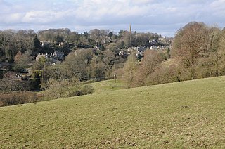
Painswick is a town and civil parish in the Stroud District in Gloucestershire, England. Originally the town grew from the wool trade, but it is now best known for its parish church's yew trees and the local Rococo Garden. The village is mainly constructed of locally quarried Cotswold stone. Many of the buildings feature south-facing attic rooms once used as weavers' workshops.

Blockley is a village, civil parish and ecclesiastical parish in the Cotswold district of Gloucestershire, England, about 3 miles (5 km) northwest of Moreton-in-Marsh. Until 1931 Blockley was an exclave of Worcestershire.

<span class="mw-page-title-main">Abberley</span> Human settlement in England

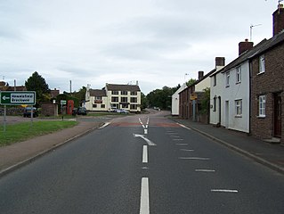
Abberley is a village and civil parish in north west Worcestershire, England.

<span class="mw-page-title-main">Much Marcle</span> Human settlement in England

Much Marcle is a village and civil parish in Herefordshire, England, located 7 miles (11 km) north-east of Ross-on-Wye. The 2011 Census recorded the parish's population as 660. The name Marcle comes from the Anglo-Saxon word for a boundary field, mearc-leah. Much, in this case, means large or great, from the Middle English usage of the word.

<span class="mw-page-title-main">West Overton</span> Human settlement in England

West Overton is a village and civil parish in the English county of Wiltshire, about 3.5 miles (5.6 km) west of Marlborough. The river Kennet runs immediately north of the village, separating it from the A4 road. The parish includes the village of Lockeridge, also near the river, further east (downstream).

<span class="mw-page-title-main">Coalpit Heath</span> Human settlement in England

Coalpit Heath is a small village in the civil parish of Westerleigh and Coalpit Heath, in the South Gloucestershire district, in the ceremonial county of Gloucestershire, England, south of Yate and east of Frampton Cotterell.

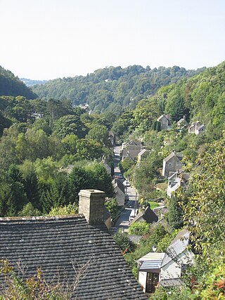
Brimscombe and Thrupp is a civil parish made up of the villages of Thrupp and Brimscombe, in the narrow Frome Valley slightly south-east of Stroud, Gloucestershire, England. The parish also includes the hamlets of Quarhouse and The Heavens. The population taken at the 2011 census was 1,830.

<span class="mw-page-title-main">Chalford</span> Human settlement in England

Chalford is a large village in the Frome Valley of the Cotswolds in Gloucestershire, England. It is to the southeast of Stroud about four miles upstream. It gives its name to Chalford parish, which covers the villages of Chalford, Chalford Hill, France Lynch, Bussage and Brownshill, spread over two square miles of the Cotswold countryside. At this point the valley is also called the Golden Valley.

<span class="mw-page-title-main">Bisley, Gloucestershire</span> Village in Gloucestershire, England

Bisley is a village and former civil parish, now in the parish of Bisley-with-Lypiatt, in the Stroud district, in Gloucestershire, England, about 4 miles (6 km) east of Stroud. The once-extensive manor included Stroud and Chalford, Thrupp, Oakridge, Bussage, Througham and Eastcombe. In 1891 the parish had a population of 5171.

<span class="mw-page-title-main">Alvington, Gloucestershire</span> Human settlement in England

Alvington is a village and civil parish in the Forest of Dean in Gloucestershire, England, situated on the A48 road, six miles north-east of Chepstow in Wales. The parish had a total population of 506 at the 2011 census.

<span class="mw-page-title-main">Arlingham</span> Human settlement in England

Arlingham is a village and civil parish in the Stroud District of Gloucestershire, England. The 2021 Census recorded a parish population of 533. The parish contains the hamlets of Milton End, Overton and Priding. The next parish to the east is Fretherne with Saul.

<span class="mw-page-title-main">Bisley-with-Lypiatt</span> Civil parish in Stroud, England

Bisley-with-Lypiatt is a civil parish in the Stroud district of Gloucestershire, England. It had a population of 2350 in 2019. It includes Bisley, Lypiatt, Eastcombe and Oakridge.

<span class="mw-page-title-main">Claypole, Lincolnshire</span> Village and civil parish in the South Kesteven district of Lincolnshire, England

Claypole is a village and civil parish in the South Kesteven district of Lincolnshire, England. The population of the civil parish at the 2011 census was 1,382. It is situated 4 miles (6.4 km) south-east from the market town of Newark-on-Trent, just east of the Grantham to Newark stretch of the A1.

<span class="mw-page-title-main">Nympsfield</span> Human settlement in England

Nympsfield is a village and civil parish in the English county of Gloucestershire. It is located around four miles south-west of the town of Stroud. As well as Nympsfield village, the parish contains the hamlet of Cockadilly. The population taken at the 2011 census was 382.

<span class="mw-page-title-main">Clifton upon Teme</span> Human settlement in England

Clifton upon Teme is a village and civil parish in the Malvern Hills District in the county of Worcestershire, England.

<span class="mw-page-title-main">Didmarton</span> Human settlement in England

Didmarton is a village and civil parish in Gloucestershire, England. It lies in the Cotswold District, about 6 miles (10 km) southwest of Tetbury. The parish is on the county borders with South Gloucestershire and Wiltshire.

<span class="mw-page-title-main">Eastcombe, Gloucestershire</span> Human settlement in England

Eastcombe is a village in Stroud District in Gloucestershire, England.

Thomas Keble was a Church of England clergyman, younger brother of John Keble. Keble was Vicar of Bisley, Gloucestershire from 1827 to 1873. He contributed four of the Tracts for the Times, three of them under a pseudonym also used by his brother, Richard Nelson.

References

  1. 1 2 "Bussage". Chalford Parish Local History Group. Retrieved 5 July 2020.
  2. "St Michael and All Angels". A Church Near You. Church of England. Retrieved 5 July 2020.
  3. "Church of St Michael and All Angels". National Heritage List for England. Historic England. Retrieved 5 July 2020.
  4. "The Ram Inn". The Ram Inn. Archived from the original on 16 September 2019. Retrieved 5 July 2020.
  5. "Bussage Primary School". Bussage Primary School. Archived from the original on 4 December 2019. Retrieved 5 July 2020.
  6. "Minutes of Gloucestershire Commons and Rights of Way Committee, September 2005" (PDF). Archived (PDF) from the original on 7 May 2012. Retrieved 1 December 2011.
  7. "Gloucestershire Wildlife Trust - Frith Wood". Archived from the original on 26 March 2013. Retrieved 17 April 2012.
  8. "ArcGIS Web Application". stroud.maps.arcgis.com. Retrieved 26 December 2021.