Bwllfa Colliery

Last updated
Bwllfa Colliery
Location
Location Cwmdare
Country Wales
Coordinates 51°42′40″N3°29′31″W / 51.7111°N 3.4920°W / 51.7111; -3.4920 Coordinates: 51°42′40″N3°29′31″W / 51.7111°N 3.4920°W / 51.7111; -3.4920
Production
Products Ironstone, Steam coal
History
Opened1853 (1853)
Active1856-1957
Closed1977

Bwllfa Colliery was a coal mine, located in the Dare valley near Cwmdare in Rhondda Cynon Taf, South Wales. It operated from 1856 to 1957, remaining open as a ventilation shaft for Mardy Colliery until 1989

Contents

Development

Bwllfa No.1

In 1853, Sam and Joseph Thomas began sinking a pit shaft within the remote farming community at the top of the Dare Valley. The two shafts were 200 yards (180 m) deep, and initially operated by water balance winding, with ventilation from a furnace. Production commenced in 1856, but by 1857 business partner Ebenezer Lewis was the sole owner. [1]

Nantmelyn Colliery

In 1856, Mordecai Jones began sinking the shaft of the Nantmelyn Colliery ( 51°42′50″N3°29′09″W / 51.714°N 3.4857°W / 51.714; -3.4857 (Nantmelyn Colliery) ). After opening in 1860, by 1864 the Bwllfa Colliery Company were the owners. In 1867 they sunk a second 150 yards (140 m) deep shaft, ventilated by Guibal fan. Brogden and Sons took over the colliery in 1873. [1]

Operations

In 1876, the two pits were merged under the combined Bwlfa and Merthyr Dare Coal Company. After a series of accidents criticised by the HM Inspectorate of Mines, seeking new investment the company reformed as the Bwllfa and Merthyr Dare Steam Collieries (1891) Ltd., allowing opening of the Gorllwyn level in 1891. [1]

By 1896, No.1 pit employed 1,128, while renamed Nantmelyn now Bwllfa No.2 employed an additional 231. In 1907, the company took over the mineral rights to the old Powell's pit (also known as Pwll Troedrhiwllech and Cwmdare Pit), opened By Thomas Powell 1851, which it reopened as Bwllfa No.3. [1]

Like many mines, the company lost some of its workforce during World War I, but by the end of 1918 this had recovered to: 1,054 at No.1; 931 at No.2/new drift No.4; 423 at No.3. Due to its ease of access, in 1922 the first electric powered coal cutting machines to be used in the South Wales coalfield were installed at Bwllfa No.3. By 1923, producing both ironstone and steam coal: [1]

Taken over by the Bwllfa and Cwmaman Coal Co. in 1928, part of Welsh Associated Collieries, in 1935 WAC merged its mining investments with those of Powell Duffryn. The new company decided to cease production from No.3, which became a ventilation shaft. [1]

Post World War II, by the time of nationalisation under the National Coal Board, Powell Duffryn had also ceased production at No.1, equipping it as a ventilation shaft and pumping station. Coal was now only raised from No.2 and No.4, with a total below and above ground workforce of 572. [1]

Housing and amenities

The influx of miners to what had been up to this point an isolated farming community necessitated the construction of housing to support them. Between 1853 and 1859, the first streets were laid down on the west side of the Dare Valley, which would become the centre of the village of Cwmdare. At the same time, a small collection of houses were constructed on the east side of the valley, near the Merthyr Dare Colliery, which became known as Pithead. As the collieries grew over the next century, Cwmdare grew with it, with rows of terraced miner's cottages being built to the north-west of the original hamlet to create homes for the expanding workforce. Merthyr Dare closed in 1884, and Cwmdare Colliery in 1936.

Transport

Two separate railway lines operated in the area operated by rival companies. The Dare and Aman Branch of the Vale of Neath Railway reached Bwllfa Colliery in 1857. This railway reached Cwmdare from Gelli Tarw near Llwydcoed, crossing the Gamlyn Viaduct at Penywaun and Dare Viaduct, both designed by Isambard Kingdom Brunel. [2]

In 1866, and extension by the Taff Vale Railway followed a route near the River Dare from a junction close to Aberdare. [2]

Closure

With coal being mined from under the Maerdy mountain from both sides, it was only a matter of time before the economics of production dictated the closure of one of the two mines.

In 1949 the NCB had made a £7-million investment in Mardy Colliery, creating capacity for No.3 and No.4 shafts to access 100 million tons of coal in the 5 ft seam, estimated sufficient to last for one hundred years. [3] It had been transformed into one of the most modern pits in the United Kingdom, with fully electric winding, new extended railway sidings and a coal washing plant on the surface. [4]

In 1957, further investment in Mardy created new underground roads linking the mine directly to Bwllfa. [3] At this point the decision was made to stop raising coal from Bwllfa which would be kept open only for ventilation and water extraction. By 1977, workings at Mardy had moved further north and east, and the decision was made to close the last shaft at Bwllfa. [1]

Northern view of Dare Valley Country Park, showing the former pit winding gear of Nantmelyn Colliery Darevalleycountrypark-photo-by-aberdare-blog.jpg
Northern view of Dare Valley Country Park, showing the former pit winding gear of Nantmelyn Colliery

Present

In 1970, a country park was proposed for the area. After planning and two years of land reclamation work, involving the clearing of coal tips and re-routing of the River Dare, Dare Valley Country Park was opened in December 1973. It includes many historical remnants of the coal mining past, including coal trams and the pit winding gear from Nantmelyn Colliery which forms part of the monument.

Related Research Articles

Pengam Human settlement in Wales

Pengam is a former coal village and community in the Rhymney Valley, Caerphilly county borough, in Wales. It is also a community, containing itself and the nearby village of Fleur de Lys, and at the 2001 census it has a population of 3,842, rising slightly to 3,848 at the 2011 Census.

Cwmdare Human settlement in Wales

Cwmdare is a village near Aberdare, in Rhondda Cynon Taf, Wales. The village's history is intertwined with coal-mining, and since the decline of the industry in the 1980s, it has become primarily a commuter base for the larger surrounding towns of Aberdare and Merthyr Tydfil and Pontypridd, as well as the cities of Cardiff and Swansea.

Tower Colliery Historic Welsh coal mine active until 2008

Tower Colliery was the oldest continuously working deep-coal mine in the United Kingdom, and possibly the world, until its closure in 2008. It was the last mine of its kind to remain in the South Wales Valleys. It was located near the villages of Hirwaun and Rhigos, north of the town of Aberdare in the Cynon Valley south Wales.

Rhondda Heritage Park

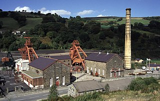
Rhondda Heritage Park, Trehafod, Rhondda, South Wales is a tourist attraction which offers an insight into the life of the coal mining community that existed in the area until the 1980s.

Blaenllechau Human settlement in Wales

Blaenllechau is a small village located in the Rhondda Fach valley, Rhondda Cynon Taf. Neighbouring villages are Ferndale, Maerdy and Tylorstown. The population of Blaenllechau is less than 1000.

Cefn Coed Colliery Museum Mining museum in Neath Port Talbot, Wales

Cefn Coed Colliery Museum is a former coal mine, now operating as a museum. It is located at Crynant near Neath in the South Wales Valleys.

The Elsecar Collieries were the coal mines sunk in and around Elsecar, a small village to the south of Barnsley in what is now South Yorkshire, but was traditionally in the West Riding of Yorkshire.

Dare Valley Country Park

Dare Valley Country Park is a public park in Wales. It lies near the village of Cwmdare and the town of Aberdare, Cynon Valley, in Rhondda Cynon Taff, South Wales. It comprises 500 acres (2.0 km2) of woodlands, pasture and moorland mountainside. It is maintained by the local Council, Rhondda Cynon Taf.

Chatterley Whitfield Collieries of The North Staffordshire Coalfield

Chatterley Whitfield Colliery is a disused coal mine on the outskirts of Chell, Staffordshire in Stoke on Trent. It was the largest mine working the North Staffordshire Coalfield and was the first colliery in the UK to produce 1,000,000 tons of saleable coal in a year. The colliery and pithead baths complex are on Historic England's Heritage at Risk Register due to being in very bad condition and not in use. In September 2019, it was named on the Victorian Society's list of the top ten most endangered buildings in England and Wales.

Penallta Colliery

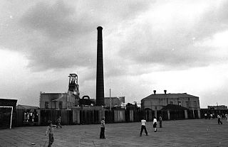
Penallta Colliery was a coal mine, located close to Hengoed in the Rhymney Valley in the South Wales Valleys. A coal mine which in 1935 held the European record for coal wound in a 24-hour period, it is now the site of an original redevelopment project which will make use of the former pit head buildings.

Nantgarw Colliery was a coal mine and later developed Coking coal works, located in the village on Nantgarw, Mid Glamorgan, Wales located just north of Cardiff.

Abercynon Colliery Welsh coal mine active 1889-1988

Abercynon Colliery was a coal mine located in Abercynon, South Wales. Opened in 1889, it closed in 1988.

Tynewydd Human settlement in Wales

Tynewydd is a village located in the County Borough of Rhondda Cynon Taf, south Wales. With Treherbert, Blaencwm, Blaenrhondda and Pen-yr-englyn it is part of a community of Treherbert. The village lies in the former industrial coal mining area at the head of Rhondda Fawr, the larger of the Rhondda Valleys.

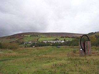
Maerdy Colliery was a coal mine located in the South Wales village of Maerdy, in the Rhondda Valley, located in the county borough of Rhondda Cynon Taf, and within the historic county boundaries of Glamorgan, Wales. Opened in 1875, it closed in December 1990.

Ferndale Colliery was a series of nine coal mines, located close to the village of Ferndale, Rhondda Cynon Taf in the Rhondda Valley, South Wales.

Astley Green Colliery

Astley Green Colliery was a coal mine in Astley, Greater Manchester, then in the historic county of Lancashire, England. It was the last colliery to be sunk in Astley. Sinking commenced in 1908 by the Pilkington Colliery Company, a subsidiary of the Clifton and Kersley Coal Company, at the southern edge of the Manchester Coalfield, working the Middle Coal Measures where they dipped under the Permian age rocks under Chat Moss. The colliery was north of the Bridgewater Canal. In 1929 it became part of Manchester Collieries, and in 1947 was nationalised and integrated into the National Coal Board. It closed in 1970, and is now Astley Green Colliery Museum.

Parsonage Colliery

Parsonage Colliery was a coal mine operating on the Lancashire Coalfield in Leigh, then in the historic county of Lancashire, England. The colliery, close to the centre of Leigh and the Bolton and Leigh Railway was sunk between 1913 and 1920 by the Wigan Coal and Iron Company and the first coal was wound to the surface in 1921. For many years its shafts to the Arley mine were the deepest in the country. The pit was close to the town centre and large pillars of coal were left under the parish church and the town's large cotton mills.

Mosley Common Colliery was a coal mine originally owned by the Bridgewater Trustees operating on the Manchester Coalfield after 1866 in Mosley Common, Greater Manchester, then in the historic county of Lancashire, England. The colliery eventually had five shafts and became the largest colliery on the Lancashire Coalfield with access to around 270 million tons of coal under the Permian rocks to the south.

Deep Navigation Colliery coal mine in South Wales (1872–1991)

Deep Navigation Colliery was a coal mine in South Wales, that operated from 1872 until 1991.

Great Western Mine mine in the United Kingdom

Great Western Mine, also known as Hetty Pit, was a coal mine, at Hopkinstown, near Pontypridd, Glamorgan in South Wales.

References

  1. 1 2 3 4 5 6 7 8 "Bwllfa Colliery". Welsh Coalmines. Retrieved 21 July 2012.
  2. 1 2 Cwmdare Archived 2007-08-16 at the Wayback Machine
  3. 1 2 "Maerdy". Rhondda Cynon taff. Archived from the original on 17 July 2011. Retrieved 23 December 2010.
  4. "Mardy Colliery". coflein.gov.uk. Retrieved 2010-12-23.