Cabo Rojo National Wildlife Refuge

Last updated
Cabo Rojo National Wildlife Refuge
IUCN category IV (habitat/species management area)
Cabo Rojo salt flats.jpg
Cabo Rojo Salt Flats
USA Puerto Rico location map.svg
Red pog.svg
Map of Puerto Rico
Location Cabo Rojo, Puerto Rico, Caribbean
Coordinates 17°58′45″N67°10′06″W / 17.97917°N 67.16833°W / 17.97917; -67.16833 Coordinates: 17°58′45″N67°10′06″W / 17.97917°N 67.16833°W / 17.97917; -67.16833
Area1,836 acres (7.43 km2)
Established1974
Governing body U.S. Fish and Wildlife Service
Website www.fws.gov/refuge/Cabo_Rojo

Cabo Rojo National Wildlife Refuge (Spanish: Refugio Nacional de Vida Silvestre de Cabo Rojo) is an 1,836-acre National Wildlife Refuge located in southwestern Puerto Rico, in the municipality of Cabo Rojo. The refuge is a habitat for number of native bird species including the endangered yellow-shouldered blackbird, locally known as mariquita de Puerto Rico or capitán. Many birds find their way to the refuge while migrating between North and South America, and more than 118 bird species have been recorded near the area.

Contents

The Cabo Rojo National Wildlife Refuge is administered as part of the Caribbean Islands National Wildlife complex. [1]

History

The refuge was established in 1974, when 587 acres of land were obtained by the U.S. Fish and Wildlife Service from the Central Intelligence Agency which had operated the Caribbean Bureau of the Foreign Broadcast Information Service there for a number of years. [1]

In 1999, the FWS purchased and added to the refuge the Cabo Rojo Salt Flats, a historic salt mining site located near the Los Morrillos Lighthouse. This site dates to 700 C.E. and is considered one of the oldest industries in the Americas. [2] Caborrojeños Pro Salud y Ambiente, a local civic group, runs a visitor center in the salt flats area. [3]

Features

The Cabo Rojo National Wildlife Refuge was established to protect the rolling hills, grasslands, mangroves and subtropical dry forests of Cabo Rojo. [4] Due to decades of overgrazing, much of the native vegetation has been replaced by plants from other regions. Invasive species like the grasses that feed cattle are considered undesirable because they compete with the native vegetation, reducing diversity and therefore decreasing optimal food and nesting habitat for the native wildlife. Grassland management, through haying, has allowed native grasses to grow back and provide a better home for the native fauna. Additionally, native trees are being planted to return the land to its original mature hardwood forest. [1]

Special designations

The Cabo Rojo National Wildlife Refuge has been designated a Critical Habitat for the yellow-shouldered blackbird ( Agelaius xanthomus ), and the Cabo Rojo Salt Flats are recognized as an Important Critical Wildlife site within the refuge. The refuge has also been declared a BirdLife International Important Bird Area (under the name Suroeste de Puerto Rico) and was the first Caribbean site to be added to the Western Hemisphere Shorebird Reserve Network (WHSRN). [1]

Wildlife

Cabo Rojo National Refuge is home to 245 plant species and 145 bird species, including shore and land birds. Some of the bird species found in the refuge include the American kestrel ( Falco sparverius ), the smooth-billed ani ( Crotophaga ani ), the black-necked stilt ( Himantopus mexicanus ), the yellow or mangrove warbler ( Setophaga petechia ), the Adelaide's warbler ( Setophaga adelaidae ), the troupial (Icterus icterus) which was introduced from Venezuela, the semipalmated plover ( Charadrius semipalmatus ), the Wilson's plover (Charadrius wilsonia) and the Puerto Rican woodpecker (Melanerpes portoricensis). [5]

The refuge is also home to a large number of endemic reptiles and amphibians such as the Puerto Rican red-eyed frog ( Eleutherodactylus antillensis ), the Cuban tree frog ( Osteopilus septentrionalis ) and the white-lipped frog ( Leptodactylus albilabris ). [6] Native plants found in the refuge include the cobana negra ( Stahlia monosperma ), the pipe-organ cactus ( Cephalocerus royenii ), the West Indian birch ( Bursera simaruba ) and the guayacan ( Guaiacum officinale ). [7]

Adjacent protected areas

The Cabo Rojo National Wildlife Refuge is located close to the Laguna Cartagena National Wildlife Refuge, both of which are administered as part of the Caribbean Islands National Wildlife complex. The national wildlife refuge is also adjacent to different units belonging to the Boquerón State Forest, which protects the mangrove forests that stretch from Cabo Rojo to Lajas, and the Cabo Rojo National Natural Landmark. [8]

See also

Related Research Articles

<span class="mw-page-title-main">United States Fish and Wildlife Service</span> United States federal government agency

The United States Fish and Wildlife Service is an agency within the United States Department of the Interior dedicated to the management of fish, wildlife, and natural habitats. The mission of the agency is "working with others to conserve, protect, and enhance fish, wildlife, plants and their habitats for the continuing benefit of the American people."

<span class="mw-page-title-main">Cabo Rojo, Puerto Rico</span> City and municipality in Puerto Rico

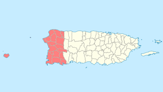
Cabo Rojo is a city and municipality situated on the southwest coast of Puerto Rico and forms part of the San Germán–Cabo Rojo metropolitan area as well as the larger Mayagüez–San Germán–Cabo Rojo Combined Statistical Area.

<span class="mw-page-title-main">Puerto Rican dry forests</span> Dry forests in southern Puerto Rico

The Puerto Rican dry forests are a tropical dry forest ecoregion located in southwestern and eastern Puerto Rico and on the offshore islands. They cover an area of 1,300 km2 (500 sq mi). These forests grow in areas receiving less than 1,000 mm (39 in) of rain annually. Many of the trees are deciduous, losing their leaves during the dry season which normally lasts from December to April.

Caborrojeños Pro Salud y Ambiente, Inc. is a non-profit environmentalist organization based in Cabo Rojo, Puerto Rico.

<span class="mw-page-title-main">Faro Los Morrillos de Cabo Rojo</span> Lighthouse in Cabo Rojo, Puerto Rico

Faro Los Morrillos de Cabo Rojo, also known as Los Morrillos Light, is a historic lighthouse located in Los Morrillos cape in the municipality of Cabo Rojo, Puerto Rico.

<span class="mw-page-title-main">Yellow-shouldered blackbird</span> Species of bird

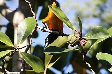
The yellow-shouldered blackbird, known in Puerto Rican Spanish as mariquita de Puerto Rico or capitán, is a species of blackbird endemic to Puerto Rico. It has black plumage with a prominent yellow patch on the wing. Adult males and females are of similar appearance. The species is predominantly insectivorous.

<span class="mw-page-title-main">Fauna of Puerto Rico</span>

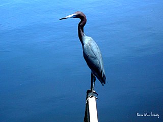
The fauna of Puerto Rico is similar to other island archipelago faunas, with high endemism, and low, skewed taxonomic diversity. Bats are the only extant native terrestrial mammals in Puerto Rico. All other terrestrial mammals in the area were introduced by humans, and include species such as cats, goats, sheep, the small Indian mongoose, and escaped monkeys. Marine mammals include dolphins, manatees, and whales. Of the 349 bird species, about 120 breed in the archipelago, and 47.5% are accidental or rare.

Caribbean Islands National Wildlife Complex is an administrative unit of the United States Fish and Wildlife Service which oversees National Wildlife Refuges in Puerto Rico, the U.S. Virgin Islands, and Navassa Island of the U.S. Minor Outlying Islands. The NWR complex also manages the reintroduction of the critically endangered Puerto Rican parrot into the wild.

<i>Libidibia monosperma</i> Species of legume

Libidibia monosperma is a species of legume in the family Fabaceae, with the common names cóbana negra and cóbana polisandro. It is found in the Dominican Republic, Puerto Rico, and the United States Virgin Islands. It is a federally listed threatened species of the United States.

<span class="mw-page-title-main">Tortuguero Lagoon</span> Natural reservoir located between Vega Baja and Manatí, Puerto Rico

Laguna Tortuguero Natural Reserve is a natural reservoir located between the municipalities of Vega Baja and Manatí in Puerto Rico.

Cullingford Field was an airstrip owned and operated by the United States Fish and Wildlife Service near Boquerón in the municipality of Cabo Rojo, Puerto Rico. Located within the Cabo Rojo National Wildlife Refuge, it was used exclusively by Fish and Wildlife personnel.

<span class="mw-page-title-main">Boquerón, Cabo Rojo, Puerto Rico</span> Barrio of Puerto Rico

Boquerón is a barrio in the municipality of Cabo Rojo, Puerto Rico. Its population in 2010 was 5,373. The village of Boquerón, located on the Boquerón Bay is one of the main tourist attractions in the southwestern part of the island. In 2000, its population was 4,963.

<span class="mw-page-title-main">Culebra National Wildlife Refuge</span> National wildlife refuge in the Puerto Rico archipelago

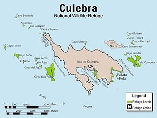
The Culebra National Wildlife Refuge is a National Wildlife Refuge in Puerto Rico. It is part of the Caribbean Islands National Wildlife Refuge Complex, which is a unit of the U.S. Fish and Wildlife Service. It is the site of the former Camp Roosevelt.

<span class="mw-page-title-main">Porta del Sol</span> Tourism region in western Puerto Rico

Porta del Sol is a tourism region in western Puerto Rico. It consists of 17 municipalities in the western area: Quebradillas, Isabela, San Sebastián, Moca, Aguadilla, Aguada, Rincón, Añasco, Mayagüez, Las Marías, Maricao, Hormigueros, San Germán, Sábana Grande, Guánica, Lajas and Cabo Rojo. Porta del Sol was established in 2003 by the Puerto Rico Tourism Company. The name translates to "Doorway to the Sun"

<span class="mw-page-title-main">Sierra Bermeja</span> Mountain range in Puerto Rico

Sierra Bermeja is a mountain range in southwestern Puerto Rico. It forms the southern boundary of the Lajas Valley and it is bordered by La Parguera in the Caribbean Sea coast. It extends from the municipality of Cabo Rojo in the west to Lajas in the east. It consists of a combination of volcanic rocks, completely crossed by serpentinite and amphibolite faults, which could well be the oldest known rock in Puerto Rico. The mountains were used by the Taíno people as refuge from the Spanish, and then by smugglers during the Spanish colonization.

<span class="mw-page-title-main">Fauna of the United States Virgin Islands</span>

The fauna of the United States Virgin Islands consists of 144 species of birds, 22 species of mammals, 302 species of fish and 7 species of amphibians. The wildlife of the U.S.V.I. includes numerous endemic species of tropical birds, fish, and land reptiles as well as sea mammals. The only endemic land mammals are six species of native bats: the greater bulldog bat, Antillean fruit-eating bat, red fruit bat, Brazilian free-tailed bat, velvety free-tailed bat and the Jamaican fruit bat. Some of the nonnative land mammals roaming the islands are the white-tailed deer, small Asian mongoose, goats, feral donkeys, rats, mice, sheep, hogs, dogs and cats.

<span class="mw-page-title-main">Caño Tiburones</span> Nature reserve in Puerto Rico

Caño Tiburones is a wetland and nature reserve located in the northern coast of Puerto Rico in the municipalities of Arecibo and Barceloneta. This is one of the largest wetlands in Puerto Rico, covering almost 7,000 acres. A large portion of the swamp, located in Arecibo, is protected as the Caño Tiburones Nature Reserve.

<span class="mw-page-title-main">Boquerón State Forest</span>

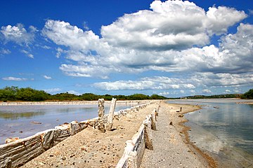
Boquerón State Forest is one of the 20 forestry units that make up the public forest system of Puerto Rico. Despite its name, the Boquerón State Forest is not only located in Boquerón, Cabo Rojo but also spans almost 5,000 acres across the municipalities of Cabo Rojo, Lajas and Mayagüez. The forest area is also known for its limestone cliffs, the lighthouse, and the salt flats which have been a source of salt since the pre-Hispanic era and dating to 700 C.E. it is considered one of the oldest industries in the Americas.

<span class="mw-page-title-main">Los Morrillos (Cabo Rojo)</span> Cape and tombolo landform located in Puerto Rico

Los Morrillos de los Cabos Rojos or more commonly known as Los Morrillos de Cabo Rojo, is a cape and tombolo landform located in southwestern Puerto Rico in the municipality of Cabo Rojo. Los Morrillos is an excellent example of a tombolo, or a tied island, with two sand pits. The cape resembles a letter Y with its two promontories or morrillos being connected through sand pits which enclose a saltwater lagoon. The landform was designated a National Natural Landmark in 1980, and the site includes mangroves, beaches, important bird nesting areas, limestone caves, cliffs and rock formations. The reddish-colored limestone cliffs give the name to the town and municipality of Cabo Rojo.

References

  1. 1 2 3 4 "About the Refuge - Cabo Rojo - U.S. Fish and Wildlife Service". www.fws.gov. Retrieved 2022-02-10.
  2. "Cabo Rojo Salt Flats (Salinas de Cabo Rojo) | The Cultural Landscape Foundation". www.tclf.org. Retrieved 2022-02-10.
  3. "Las Salinas / Salt Flats - Cabo Rojo, Puerto Rico - West Coast Things to Do". Puerto Rico Travel Guide. 2021-04-07. Retrieved 2022-02-10.
  4. "Habitats - Cabo Rojo - U.S. Fish and Wildlife Service". www.fws.gov. Retrieved 2022-02-10.
  5. "Birds - Cabo Rojo - U.S. Fish and Wildlife Service". www.fws.gov. Retrieved 2022-02-10.
  6. "Frogs and Toads - Cabo Rojo - U.S. Fish and Wildlife Service". www.fws.gov. Retrieved 2022-02-10.
  7. "Plants - Cabo Rojo - U.S. Fish and Wildlife Service". www.fws.gov. Retrieved 2022-02-10.
  8. "El Bosque Estatal de Boquerón". DRNA. 2015-06-12. Retrieved 2022-02-10.