
The Andes, Andes Mountains or Andean Mountain Range are the longest continental mountain range in the world, forming a continuous highland along the western edge of South America. The range is 8,900 km (5,530 mi) long and 200 to 700 km wide and has an average height of about 4,000 m (13,123 ft). The Andes extend from South to North through seven South American countries: Argentina, Chile, Bolivia, Peru, Ecuador, Colombia, and Venezuela.
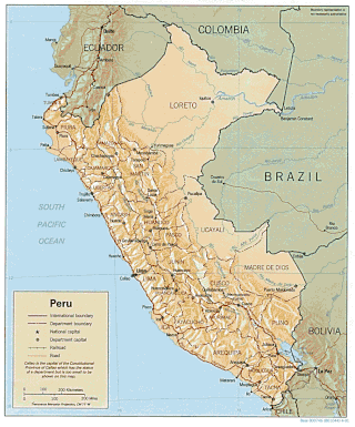
Peru is a country on the central western coast of South America facing the Pacific Ocean. It lies wholly in the Southern Hemisphere, its northernmost extreme reaching to 1.8 minutes of latitude or about 3.3 kilometres (2.1 mi) south of the equator. Peru shares land borders with Ecuador, Colombia, Brazil, Bolivia, and Chile, with its longest land border shared with Brazil.

The geography of Bolivia includes the Eastern Andes Mountain Range which bisects Bolivia roughly from north to south. To the east of that mountain chain are lowland plains of the Amazon Basin, and to the west is the Altiplano which is a highland plateau where Lake Titicaca is located. Bolivia's geography has features similar to those of Peru which abuts Bolivia's northwest border; like Bolivia, Peru is bisected from north to south by the Eastern Andes Mountains, and these two countries share Lake Titicaca which is the highest navigable lake on Earth. Unlike Peru, however, Bolivia is one of the two landlocked countries in South America, the other being Paraguay, which is located along Bolivia's southeast border.

Chile has a long history in the production of wine, with roots dating back to the 16th century when the Spanish conquistadors introduced Vitis vinifera vines to the region. In the mid-19th century, French wine varieties such as Cabernet Sauvignon, Merlot, Carmenère, and Cabernet Franc were introduced. During the early 1980s, the Chilean wine industry underwent a renaissance with the introduction of stainless steel fermentation tanks and the use of oak barrels for aging. This led to a rapid growth in exports as quality wine production increased. The number of wineries in Chile rose from 12 in 1995 to over 70 in 2005.

The Biobío River is the second largest river in Chile. It originates from Icalma and Galletué lakes in the Andes and flows 380 km to the Gulf of Arauco on the Pacific Ocean.

The Los Ríos Region is one of Chile's 16 regions, the country's first-order administrative divisions. Its capital is Valdivia. It began to operate as a region on October 2, 2007, having been created by subdividing the Los Lagos Region in southern Chile. It consists of two provinces: Valdivia and the newly created Ranco Province, which was formerly part of Valdivia Province.

U-shaped valleys, also called trough valleys or glacial troughs, are formed by the process of glaciation. They are characteristic of mountain glaciation in particular. They have a characteristic U shape in cross-section, with steep, straight sides and a flat or rounded bottom. Glaciated valleys are formed when a glacier travels across and down a slope, carving the valley by the action of scouring. When the ice recedes or thaws, the valley remains, often littered with small boulders that were transported within the ice, called glacial till or glacial erratic.

Achibueno is a river, tributary of the Loncomilla, in Linares Province, Maule Region of Chile, where it forms the border between the municipalities of Linares and Longaví.

Cachapoal Province is one of three provinces of the central Chilean region of O'Higgins (VI). Its capital is the city of Rancagua.

Zona Sur is one of the five natural regions on which CORFO divided continental Chile in 1950. Its northern border is formed by the Bío-Bío River, which separates it from the Central Chile Zone. The Southern Zone borders the Pacific Ocean to the west, and to the east lies the Andean mountains and Argentina. Its southern border is the Chacao Channel, which forms the boundary with the Austral Zone. While the Chiloé Archipelago belongs geographically to the Austral Zone in terms of culture and history, it lies closer to the Southern Zone.

The Zona Austral is one of the five natural regions into which CORFO divided continental Chile in 1950 corresponding to the Chilean portion of Patagonia. It is surrounded by the Zona Sur and the Chacao Channel to the north, the Pacific Ocean and Drake's Passage to the south and west, and the Andean mountains and Argentina to the east. If excluding Chiloé Archipelago, Zona Austral covers all of Chilean Patagonia.

Because Chile extends from a point about 625 kilometers north of the Tropic of Capricorn to a point hardly more than 1,400 kilometers north of the Antarctic Circle, within its territory can be found a broad selection of the Earth's climates.

Tinguiririca River is a river of Chile located in the Libertador General Bernardo O'Higgins Region. It rises in the Andes, at the confluence of the rivers Las Damas and Del Azufre. From its source, it flows northwest for about 56 km to the vicinity of the city of San Fernando. In this portion of its course, the river receives the waters of the tributaries Clarillo and Claro. Then the river flows southwest and then turns northwest to empty into Rapel Lake.

Palomo is a 4,860 metres (15,940 ft) high Chilean stratovolcano located in the commune of Machali, Cachapoal province, Libertador General Bernardo O'Higgins Region, west of Caldera del Atuel. Together with Tinguiririca it is one of two volcanoes in the region with evidence of Holocene volcanism. The volcano is remote and knowledge on its geology and potential volcanic hazards is limited.
Huasco River is a river of Chile located in the Huasco Province, Atacama Region. Its headwaters in the upper catchments in high-altitude Andes glaciers are the Estrecho River, a tributary of El Tránsito River, and Potrerillos River, a tributary of El Carmen River. The Huasco River begins at the confluence of El Tránsito River and El Carmen River which is located in Junta del Carmen (790ma.s.l.). A small portion of its course is impounded by a dam forming the Embalse Santa Juana.

Rapel River is a river of Chile located in the O'Higgins Region. It begins at the confluence of the rivers Cachapoal and Tinguiririca in an area best known as La Junta. At present day, this area is impounded by Rapel Dam, creating Rapel Lake.

The Dry Andes is a climatic and glaciological subregion of the Andes. Together with the Wet Andes it is one of the two subregions of the Argentine and Chilean Andes. The Dry Andes runs from the Atacama Desert in northern Chile and Northwest Argentina south to a latitude of 35°S in Chile. In Argentina the Dry Andes reaches 40°S due to the leeward effect of the Andes. According to Luis Lliboutry the Dry Andes can be defined by the distribution of penitentes. The southernmost well-developed penitentes are found on Lanín Volcano.

The Sierra Nevada National Park (SNNP) is a National Park of Venezuela located between the states of Mérida and Barinas in western Venezuela. It was created on May 2, 1952, by decree of President Germán Suárez Flamerich in an attempt to protect the Sierra Nevada de Mérida in the Andes.
Abanico Formation is a 3 kilometres (9,800 ft) thick sedimentary formation exposed in the Andes of Central Chile. The formation has been deposited in a timespan from the Eocene to the Miocene. Abanico Formation's contact with the overlying Miocene Farellones Formation has been the subject of differing interpretations since the 1960s. A small part of the formation crops out in the Mendoza Province of western Argentina.

Principal Cordillera is the Andean mountain range that makes up the boundary between Central Chile and neighbouring areas of Argentina. It is also a continental divide between the Atlantic and the Pacific watersheds. It extends in a north–south direction in the Argentine provinces of La Rioja, San Juan and Mendoza and the Chilean regions of Valparaíso, Santiago, O'Higgins and Maule. To the east of the Principal Cordillera lies the Frontal Cordillera which is fully in Argentina. Aconcagua, the tallest mountain outside Asia, lies in the Principal Cordillera.


