
A hillfort is a type of earthwork used as a fortified refuge or defended settlement, located to exploit a rise in elevation for defensive advantage. They are typically European and of the Bronze Age or Iron Age. Some were used in the post-Roman period. The fortification usually follows the contours of a hill and consists of one or more lines of earthworks, with stockades or defensive walls, and external ditches.
Yatton is a village and civil parish within the unitary authority of North Somerset, which falls within the ceremonial county of Somerset, England. It is located 11 miles (18 km) south-west of Bristol. Its population in 2011 was 7,552. The parish includes Claverham, a small village which was originally a farming hamlet.

Cadbury Castle is a Bronze and Iron Age hillfort in the civil parish of South Cadbury in the English county of Somerset. It is a scheduled monument and has been associated with King Arthur's legendary court at Camelot.

Cadbury Camp is an Iron Age hill fort in Somerset, England, near the village of Tickenham. It is a scheduled monument. Although primarily known as a fort during the Iron Age it is likely, from artefacts, including a bronze spear or axe head, discovered at the site, that it was first used in the Bronze Age and still occupied through the Roman era into the sub-Roman period when the area became part of a Celtic kingdom. The name may mean "Fort of Cador" - Cado(r) being possibly the regional king or warlord controlling Somerset, Bristol, and South Gloucestershire, in the middle to late 5th century. Cador has been associated with Arthurian England, though the only evidence for this is the reference in the Life of St. Carantoc to Arthur and Cador ruling from Dindraithou and having the power over western Somerset to grant Carantoc's plea to build a church at Carhampton. Geoffrey of Monmouth invented the title 'Duke of Cornwall' for Cador in his misleading History of the Kings of Britain.

Burledge Hill is on the southern edge of the village of Bishop Sutton, Somerset, England. It is the site of a Site of Special Scientific Interest and an univallate Iron Age hillfort.
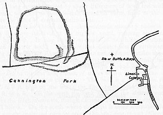
Cannington Camp is a Bronze Age and Iron Age hill fort near Cannington, Somerset, England. It is a Scheduled Ancient Monument.

Cleeve Toot is an Iron Age univallate hillfort above Goblin Combe, Cleeve, Somerset, England. It is a Scheduled Ancient Monument.

Clatworthy Camp is an Iron Age hill fort 3 miles (4.8 km) North West of Wiveliscombe, Somerset, England. It has been scheduled as an Ancient Monument. Due to the vulnerability to scrub and tree growth it has been added to the Heritage at Risk Register.
Kingsdown Camp is an Iron Age hill fort at Buckland Dinham 4.5 kilometres (3 mi) South East of Radstock, Somerset, England. It is a Scheduled Ancient Monument.
Backwell Hillfort is an Iron Age hill fort situated approximately 1.1 miles (1.8 km) from Backwell in the North Somerset district of Somerset, England. The hill fort was first discovered in 1933 with two of the three sides of the fort protected by a large ditch and a bank. In 1956, the site was nearly completely destroyed by quarrying at Coles Quarry, which ceased production in the 1970's.
Curdon Camp is a univallate Iron Age hill fort in the West Somerset district of Somerset, England. It is a Scheduled Ancient Monument.
Westbury Camp is a univallate Iron Age hill fort in the Mendip Hills in Somerset, England. The hill fort is situated in the parish of Rodney Stoke, approximately 1 mile (1.6 km) north-east of the village of Draycott and 1.5 miles (2.4 km) north-west of Westbury-sub-Mendip. The camp is largely situated in a hill slope. The north east defences have largely been destroyed by small quarries over the years. The narrow top of the hill bank suggests that it may have been surmounted by a dry stone wall. Along part of the east side of the camp there are traces of a berm between the bank and the outer ditch and at the western angle shallow quarry pits occur internally and externally set back from the 'rampart'.

Roddenbury Hillfort is a univallate Iron Age hillfort in the parish of Selwood, Somerset, England. It is a Scheduled Monument and it was on the Heritage at Risk Register in 2011. In 2012 it was announced that it was to undergo major repairs following damage by off road biking. It is close to the later Hales Castle.
Taps Combe Camp is an Iron Age hill fort in North Somerset, England. The hill fort is situated approximately 1.8 miles (2.9 km) east from the village of Brockley. The hill fort is shaped a lot like a "D", and is approximately 50 metres (160 ft) by 50 metres (160 ft) wide.

Mounsey Castle is an Iron Age irregular triangular earthwork of 1.75 hectares north west of Dulverton, Somerset, England. It has been scheduled as an ancient monument. It has been added to the Heritage at Risk Register.
Tunley Camp is an vallate Iron Age hill fort situated approximately 0.8 miles (1.3 km) north-east from the small village of Camerton in the Bath and North East Somerset district of Somerset, England. The hill fort comprises the slight earthwork remains of a univallate Iron Age hillfort which now nearly ploughed down.
Berry Castle is an early Roman hillslope enclosure in the West Somerset district of Somerset, England. The hill fort is situated approximately 3.2 miles (5.1 km) west from the village of Luccombe. A series of earthworks survive in Berry Castle; it dates from the late Iron Age or early Romano British period. It has been protected as a scheduled monument.

King's Castle is an Iron Age enclosed hilltop settlement at the south-western edge of the Mendip Hills near Wells in Somerset, England. Though there are many prehistoric sites in the surrounding area, it remains one of the earliest known settlements in the immediate vicinity of Wells, and may have been a precursor to the present day city. It consists of two or three interlinked sub-enclosures, with what appears to be a field system extending to the east; an unusual layout, the site remains relatively little studied and has not been archaeologically excavated. It is a Scheduled Ancient Monument, and shares its name with the surrounding King's Castle Wood—today a Somerset Wildlife Trust nature reserve—though this name is probably a modern invention.

