Related Research Articles

The Old Red Sandstone is an assemblage of rocks in the North Atlantic region largely of Devonian age. It extends in the east across Great Britain, Ireland and Norway, and in the west along the northeastern seaboard of North America. It also extends northwards into Greenland and Svalbard. These areas were a part of the ancient continent of Euramerica/Laurussia. In Britain it is a lithostratigraphic unit to which stratigraphers accord supergroup status and which is of considerable importance to early paleontology. For convenience the short version of the term, ORS is often used in literature on the subject. The term was coined to distinguish the sequence from the younger New Red Sandstone which also occurs widely throughout Britain.

The geology of Great Britain is renowned for its diversity. As a result of its eventful geological history, Great Britain shows a rich variety of landscapes across the constituent countries of England, Wales and Scotland. Rocks of almost all geological ages are represented at outcrop, from the Archaean onwards.

The Last Glacial Period (LGP) occurred from the end of the Eemian to the end of the Younger Dryas, encompassing the period c. 115,000 – c. 11,700 years ago. The LGP is part of a larger sequence of glacial and interglacial periods known as the Quaternary glaciation which started around 2,588,000 years ago and is ongoing. The definition of the Quaternary as beginning 2.58 million years ago (Mya) is based on the formation of the Arctic ice cap. The Antarctic ice sheet began to form earlier, at about 34 Mya, in the mid-Cenozoic. The term Late Cenozoic Ice Age is used to include this early phase.

The Anglian Stage is the name used in the British Isles for a middle Pleistocene glaciation. It precedes the Hoxnian Stage and follows the Cromerian Stage in the British Isles. The Anglian Stage is correlated to Marine Isotope Stage 12, which started about 478,000 years ago and ended about 424,000 years ago.
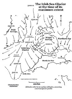
The Irish Sea Glacier was a huge glacier during the Pleistocene Ice Age that, probably on more than one occasion, flowed southwards from its source areas in Scotland and Ireland and across the Isle of Man, Anglesey and Pembrokeshire. It probably reached its maximum extent during the Anglian Glaciation, and it was also extensive during the Late Devensian Glaciation.
The Lias Group or Lias is a lithostratigraphic unit found in a large area of western Europe, including the British Isles, the North Sea, the Low Countries and the north of Germany. It consists of marine limestones, shales, marls and clays.
The geology of Lancashire in northwest England consists in the main of Carboniferous age rocks but with Triassic sandstones and mudstones at or near the surface of the lowlands bordering the Irish Sea though these are largely obscured by Quaternary deposits.

The Norwich Crag Formation is a stratigraphic unit of the British Pleistocene Epoch. It is the second youngest unit of the Crag Group, a sequence of four geological formations spanning the Pliocene to Lower Pleistocene transition in East Anglia. It was deposited between approximately 2.4 and 1.8 million years ago, during the Gelasian Stage.
The geology of Essex in southeast England largely consists of Cenozoic marine sediments from the Palaeogene and Neogene periods overlain by a suite of superficial deposits of Quaternary age.
The geology of Norfolk in eastern England largely consists of late Mesozoic and Cenozoic sedimentary rocks of marine origin covered by an extensive spread of unconsolidated recent deposits.
The Albion Glacigenic Group is a Quaternary lithostratigraphic group present in those parts of Great Britain which lie north of the southern limit of Anglian glaciation, but south of the Devensian glacial limit, and also includes deposits in the Isle of Man and offshore areas. It consists of a wide range of unconsolidated superficial deposits including till, sands, gravels, silts and clay of glacial, glaciofluvial, glaciolacustrine and glaciomarine origin. Its upper boundary is the present day ground surface or unconformable contact with units of the Caledonia Glacigenic Group, the Britannia Catchments Group or the British Coastal Deposits Group. It was previously known as the South Britain Glacigenic Group or Older Drift
The Britannia Catchments Group is a Quaternary lithostratigraphic group present in all parts of Great Britain and including the Isle of Man. It includes a wide range of deposits including alluvium, river terrace deposits, peat, head, cover sand and blown sand of fluvial, lacustrine, mass movement, periglacial and aeolian origin. Its lower boundary is defined as an unconformable contact with the underlying Albion Glacigenic Group, the Caledonia Glacigenic Group, the Dunwich Group, Crag Group or with older bedrock. Its upper boundary is generally the present day ground surface but it interfingers locally with the British Coastal Deposits Group.
The British Coastal Deposits Group is a Quaternary lithostratigraphic group present in coastal and estuarine areas around the margins of Great Britain. They are a mix of sands, gravels, silts, clays and peat and, north of a line between the Ribble and Tyne, include glacio-eustatically raised deposits. They lie unconformably on deposits of variously the Britannia Catchments Group, Albion Glacigenic Group, Caledonia Glacigenic Group, Dunwich Group, Crag Group or earlier bedrock. Their upper boundary is the present day ground surface.
The Dunwich Group is a Pleistocene lithostratigraphic group present in England north of the upper Thames and, downstream, a line drawn east from near Marlow to Clacton-on-Sea and which encompasses river terrace deposits of the Proto-Thames and other rivers. It unconformably overlies Triassic to Pleistocene bedrock and superficial deposits. In turn, it is often overlain by deposits of the Albion Glacigenic Group and sometimes by those of the Britannia Catchments Group or British Coastal Deposits Group and interfingers in places with those of the Crag Group. No deposits potentially assignable to the group have been identified north of East Anglia or the English Midlands; they are likely to have been destroyed or removed by glacial action.
The Great Britain Superficial Deposits Supergroup is a Neogene to Quaternary lithostratigraphic supergroup present across Great Britain and the Isle of Man. It includes all of the natural superficial deposits found in Great Britain and comprises the Albion Glacigenic Group, Britannia Catchments Group, British Coastal Deposits Group, Caledonia Glacigenic Group, Crag Group, Dunwich Group and Residual Deposits Group. These deposits include till, sands, gravels, silts, head, clay, peat and other materials.
The geology of Northumberland in northeast England includes a mix of sedimentary, intrusive and extrusive igneous rocks from the Palaeozoic and Cenozoic eras. Devonian age volcanic rocks and a granite pluton form the Cheviot massif. The geology of the rest of the county is characterised largely by a thick sequence of sedimentary rocks of Carboniferous age. These are intruded by both Permian and Palaeogene dykes and sills and the whole is overlain by unconsolidated sediments from the last ice age and the post-glacial period. The Whin Sill makes a significant impact on Northumberland's character and the former working of the Northumberland Coalfield significantly influenced the development of the county's economy. The county's geology contributes to a series of significant landscape features around which the Northumberland National Park was designated.
This article describes the geology of the Broads, an area of East Anglia in eastern England characterised by rivers, marshes and shallow lakes (‘broads’). The Broads is designated as a protected landscape with ‘status equivalent to a national park’.
This article describes the geology of the Cairngorms National Park, an area in the Highlands of Scotland designated as a national park in 2003 and extended in 2010. The Cairngorms National Park extends across a much wider area than the Cairngorms massif itself and hence displays rather more varied geology.
The geology of the Gower Peninsula in South Wales is central to its character and to its appeal to visitors. The peninsula is formed almost entirely from a faulted and folded sequence of Carboniferous rocks though both the earlier Old Red Sandstone and later New Red Sandstone are also present. Gower lay on the southern margin of the last ice sheet and has been a focus of interest for researchers and students in that respect too. Cave development and the use of some for early human occupation is a further significant aspect of the peninsula's scientific and cultural interest.
References
- ↑ "BGS Lexicon of Named Rock Units – Result Details". Bgs.ac.uk. Retrieved 16 January 2019.
- ↑ McMillan, A A, Hamblin, R J O, and Merritt, J W. 2005. An overview of the lithostratigraphical framework for the Quaternary and Neogene deposits of Great Britain (Onshore). British Geological Survey Research Report RR/04/04 38pp., p. 8, ISBN 0 85272 516 7