Calfpasture River

Last updated
Calfpasture River
Calfpasture River from Ramsey Gap Road.jpg
Midway between Deerfield and Goshen
USA Virginia location map.svg
Red pog.svg
Location of the mouth of the Calfpasture River in Virginia
CountryUnited States
StateVirginia
County Rockbridge County, Augusta County
Physical characteristics
SourceGordons Peak
 - location Allegheny Mountains, Augusta County, Virginia
 - coordinates 38°20′32″N79°18′15″W / 38.34222°N 79.30417°W / 38.34222; -79.30417 [1]
 - elevation3,460 ft (1,050 m) [2]
River mouth Maury River
 - locationNear Goshen, Rockbridge County, Virginia
 - coordinates 37°56′57″N79°27′34″W / 37.94917°N 79.45944°W / 37.94917; -79.45944 Coordinates: 37°56′57″N79°27′34″W / 37.94917°N 79.45944°W / 37.94917; -79.45944 [1]
 - elevation1,345 ft (410 m) [3]
Length41 mi (66 km) [4]
Discharge 
 - location Goshen [5]
 - minimum0 cu ft/s (0 m3/s)
 - average169 cu ft/s (4.8 m3/s) [5]
 - maximum21,900 cu ft/s (620 m3/s)
Basin features
Basin size144 sq mi (370 km2) [5]
Tributaries 
 - leftLittle Calfpasture River
 - rightHamilton Branch, Brattons Run

The Calfpasture River is a river in the U.S. state of Virginia. It flows about 41.0 miles (66.0 km) [4] from its source, Gordons Peak in the Allegheny Mountains, to its confluence with the Little Calfpasture River, forming the Maury River. Via the Maury, the Calfpasture's waters flow into the James River, thence Chesapeake Bay and the Atlantic Ocean.

River Natural flowing watercourse

A river is a natural flowing watercourse, usually freshwater, flowing towards an ocean, sea, lake or another river. In some cases a river flows into the ground and becomes dry at the end of its course without reaching another body of water. Small rivers can be referred to using names such as stream, creek, brook, rivulet, and rill. There are no official definitions for the generic term river as applied to geographic features, although in some countries or communities a stream is defined by its size. Many names for small rivers are specific to geographic location; examples are "run" in some parts of the United States, "burn" in Scotland and northeast England, and "beck" in northern England. Sometimes a river is defined as being larger than a creek, but not always: the language is vague.

U.S. state constituent political entity of the United States

In the United States, a state is a constituent political entity, of which there are currently 50. Bound together in a political union, each state holds governmental jurisdiction over a separate and defined geographic territory and shares its sovereignty with the federal government. Due to this shared sovereignty, Americans are citizens both of the federal republic and of the state in which they reside. State citizenship and residency are flexible, and no government approval is required to move between states, except for persons restricted by certain types of court orders. Four states use the term commonwealth rather than state in their full official names.

Virginia State of the United States of America

Virginia, officially the Commonwealth of Virginia, is a state in the Southeastern and Mid-Atlantic regions of the United States located between the Atlantic Coast and the Appalachian Mountains. Virginia is nicknamed the "Old Dominion" due to its status as the first English colonial possession established in mainland North America and "Mother of Presidents" because eight U.S. presidents were born there, more than any other state. The geography and climate of the Commonwealth are shaped by the Blue Ridge Mountains and the Chesapeake Bay, which provide habitat for much of its flora and fauna. The capital of the Commonwealth is Richmond; Virginia Beach is the most populous city, and Fairfax County is the most populous political subdivision. The Commonwealth's estimated population as of 2018 is over 8.5 million.

Contents

According to the U.S. Board on Geographic Names, variant names of the Calfpasture River include the Big Calfpasture River, Calf Pasture River, Great Calfpasture River, and North River. [1]

Course

The Calfpasture River originates on the slopes of Gordons Peak, in Augusta County, near Shenandoah Mountain, in George Washington National Forest. Its headwater tributaries drain Bald Ridge. The river flows generally southwest for most of its course.

Augusta County, Virginia County in the United States

Augusta County is a county located in the Shenandoah Valley on the western edge of the U.S. commonwealth of Virginia. It is the second-largest county in Virginia by total area, and it completely surrounds the independent cities of Staunton and Waynesboro. The county seat of Augusta is Staunton, although most of the administrative services have offices in neighboring Verona.

Shenandoah Mountain mountain in Virginia, United States of America

Shenandoah Mountain is a mountain ridge approximately 73 miles (117 km) long in Virginia and West Virginia. The steep, narrow, sandstone-capped ridge extends from northern Bath County, Virginia to southern Hardy County, West Virginia. Along the way, its crest defines the borders between Highland and Augusta counties, Virginia, and between Pendleton County, West Virginia, and Rockingham County, Virginia. The name comes from the Iroquoian word for 'deer'.

George Washington and Jefferson National Forests

The George Washington and Jefferson National Forests are U.S. National Forests that combine to form one of the largest areas of public land in the Eastern United States. They cover 1.8 million acres (7,300 km2) of land in the Appalachian Mountains of Virginia, West Virginia, and Kentucky. Approximately 1 million acres (4,000 km2) of the forest are remote and undeveloped and 139,461 acres (564 km2) have been designated as wilderness areas, which eliminates future development.

The tributary Braley Branch joins just before the Calfpasture River flows by the small settlement of West Augusta. U.S. Route 250 crosses the river at West Augusta. Continuing southwest, the river is joined by West Dry Branch from the east, then it enters Deerfield Valley, where the tributaries Tizzle Branch and Still Run join. Deerfield Valley is flanked by Shenandoah Mountain to the west and Great North Mountain to the east. The Calfpasture River flows by the small town of Little Baltimore, after which one of its main tributaries, Hamilton Branch, joins. The Calfpasture River then flows out of Deerfield Valley and through Fridley Cove, where Fridley Branch joins.

U.S. Route 250 is a route of the United States Numbered Highway System, and is a spur of U.S. Route 50. It currently runs for 514 miles (827 km) from Richmond, Virginia to Sandusky, Ohio. It passes through the states of Virginia, West Virginia, and Ohio. It goes through the cities of Richmond, Charlottesville, Staunton, and Waynesboro, Virginia; and Wheeling, West Virginia. West of Pruntytown, West Virginia, US 250 intersects and forms a short overlap with its parent US 50.

Great North Mountain mountain in United States of America

Great North Mountain is a 50-mile (80 km) long mountain ridge within the Ridge-and-valley Appalachians in the U.S. states of Virginia and West Virginia. The ridge is located west of the Shenandoah Valley and Massanutten Mountain in Virginia, and east of the Allegheny Mountains and Cacapon River in West Virginia.

Below Fridley Cove, the Calfpasture River continues flowing southwest, through the valley between Walker Mountain to the west and Great North Mountain to the east. The river passes the small town of Marble Valley, then Clayton Mill Creek joins, after which the river leaves Augusta County and enters Rockbridge County.

Rockbridge County, Virginia County in the United States

Rockbridge County is a county located in the Commonwealth of Virginia. As of the 2010 census, the population was 22,307. Its county seat is Lexington. The independent cities of Buena Vista (6,680) and Lexington (7,170) are both enclaved within the county's geographical borders.

Near the town of Goshen the Calfpasture River is joined by Mill Creek from the west and Goshen Branch from the east. State Route 42 crosses the river at Goshen, and State Route 39 follows the river from Goshen downstream to the Maury River.

Goshen, Virginia Town in Virginia, United States

Goshen is a town in Rockbridge County, Virginia, United States. The population was 406 at the 2000 census.

Just south of Goshen the tributary Brattons Run joins the Calfpasture River, which then turns eastward, passing through a gap between Bratton Mountain and Knob Mountain. The Calfpasture River then joins the Little Calfpasture River. The confluence of the two marks the beginning of the Maury River. [6]

See also

Related Research Articles

Shenandoah River river in Virginia and West Virginia, United States

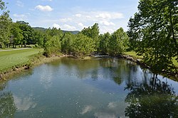
The Shenandoah River is a tributary of the Potomac River, 55.6 miles (89.5 km) long with two forks approximately 100 miles (160 km) long each, in the U.S. states of Virginia and West Virginia. The principal tributary of the Potomac, the river and its tributaries drain the central and lower Shenandoah Valley and the Page Valley in the Appalachians on the west side of the Blue Ridge Mountains, in northwestern Virginia and the Eastern Panhandle of West Virginia.

South Santiam River river in the United States of America

The South Santiam River is a tributary of the Santiam River, about 69 miles (111 km) long, in western Oregon in the United States. It drains an area of the Cascade Range into the Willamette Valley east of Corvallis.

Back Creek is a 59.5-mile-long (95.8 km) tributary of the Potomac River that flows north from Frederick County, Virginia, to Berkeley County in West Virginia's Eastern Panhandle. Back Creek originates along Frederick County's border with Hampshire County, West Virginia, at Farmer's Gap in the Great North Mountain. Its name reflects its location to the west of North Mountain. The perspective of colonists from the east in the 18th century led them to call it "Back Creek", because it lay to the back of North Mountain.

Catoctin Creek is a 14.1-mile-long (22.7 km) tributary of the Potomac River in Loudoun County, Virginia, with a watershed of 59,000 acres (240 km2). Agricultural lands make up 67 percent and forests 30 percent of Catoctin Creek's watershed. It is the main drainage system for the northern Loudoun Valley, including all of the Catoctin Valley.

Tearcoat Creek is an 18.3-mile-long (29.5 km) free-flowing tributary stream of the North River, itself a tributary of the Cacapon River, making it a part of the Potomac River and Chesapeake Bay watersheds. The creek is located in central Hampshire County, West Virginia. Its name is believed to have been derived from the tearing of the coats of British soldiers by low-hanging branches as they forded the stream during either the French and Indian or the American Revolutionary Wars.

Green Spring Run is an 8.9-mile-long (14.3 km) tributary stream of the North Branch Potomac River in Hampshire County in the U.S. state of West Virginia. Green Spring Run rises in Greenwood Hollow north of Springfield and meanders northeast through Green Spring Valley. The South Branch Valley Railroad and Green Spring Road run parallel to the stream. It runs through the community of Green Spring, from which the stream takes its name. From Green Spring, Green Spring Run flows east where it reaches its confluence with the North Branch Potomac shortly before the North Branch joins with the South Branch Potomac River to form the Potomac River.

Maury River river in the United States of America

The Maury River is a 42.8-mile-long (68.9 km) tributary of the James River in west-central Virginia in the United States. It is part of the watershed of Chesapeake Bay.

North River (South Fork Shenandoah River tributary) river in Shenandoah Valley of Virginia, United States

The North River is a 55.3-mile-long (89.0 km) river in the mountains and Shenandoah Valley of northern Virginia, the United States. It joins the South River at Port Republic to form the South Fork Shenandoah River.

Soque River river in the United States of America

The Soque River and its watershed are located entirely within the county boundaries of Habersham County in northeast Georgia. The Soque is a tributary of the Chattahoochee River. Portions of the river run along State Route 197.

Virginia State Route 42 highway in Virginia

State Route 42 is a primary state highway in the U.S. state of Virginia. Running parallel to and west of Interstate 81, SR 42 consists of three sections with gaps filled by secondary routes in between. Some of SR 42 lies along the old Fincastle and Cumberland Gap Turnpike. Another major piece, from near Clifton Forge to Buffalo Gap, parallels the old Virginia Central Railroad.

Virginia State Route 39 highway in Virginia

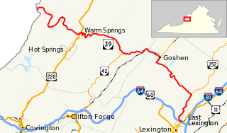
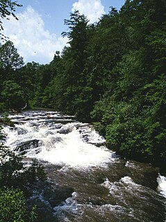
State Route 39 is a primary state highway in the U.S. state of Virginia. The state highway runs 59.17 miles (95.22 km) from the West Virginia state line near Mountain Grove, where the highway continues as West Virginia Route 39, east to U.S. Route 11 in East Lexington. SR 39 connects Lexington with several communities formed around hot springs in Bath County. In Rockbridge County, the state highway passes through the town of Goshen and Goshen Pass, a gorge formed by the Maury River.

U.S. Route 250 in Virginia highway in Virginia

U.S. Route 250 is a part of the U.S. Highway System that runs from Sandusky, Ohio to Richmond, Virginia. In Virginia, the U.S. Highway runs 166.74 miles (268.34 km) from the West Virginia state line near Hightown east to its eastern terminus at US 360 in Richmond. US 250 is the main east–west highway of Highland County, which is known as Virginia's Little Switzerland; the highway follows the path of the 19th century Staunton and Parkersburg Turnpike. From Staunton east to Richmond, the U.S. Highway serves as the local complement to Interstate 64 (I-64), roughly following the 18th century Three Notch'd Road through Waynesboro and Charlottesville on its way through the Shenandoah Valley, its crossing of the Blue Ridge Mountains at Rockfish Gap, and the Piedmont. In the Richmond metropolitan area, US 250 is known as Broad Street, a major thoroughfare through the city's West End and downtown areas.

Buffalo Creek is a 4.1-mile-long (6.6 km) free-flowing tributary stream of the South Branch Potomac River, itself a tributary of the Potomac River, making it a part of the Chesapeake Bay watershed. Buffalo Creek is located in west-central Hampshire County in the U.S. state of West Virginia. Because the stream flows through several small farms, Buffalo Creek primarily serves agriculture purposes with segments used for livestock watering.

Passumpsic River river in the United States of America

The Passumpsic River is a 22.7-mile-long (36.5 km) tributary of the Connecticut River, in Vermont. Though primarily a Caledonia County river, it is the only river to flow through all three counties of the Northeast Kingdom.

Smith Creek is a 35.5-mile-long (57.1 km) tributary stream of the North Fork of the Shenandoah River in the Shenandoah Valley of Virginia. Its watershed comprises 106 square miles (270 km2) within Shenandoah and Rockingham counties on the western slope of the Massanutten Mountain ridge. Its headwaters lie in Rockingham County just north of Harrisonburg, and its confluence with the North Fork of the Shenandoah River is located just south of Mount Jackson.

The Little Calfpasture River is a 23.7-mile-long (38.1 km) tributary of the Maury River in the U.S. state of Virginia. It is part of the James River watershed.

The South River is a 20.3-mile-long (32.7 km) tributary of the Maury River in the U.S. state of Virginia. It is part of the James River watershed.

Satsop River river in the United States of America

The Satsop River is a stream in the U.S. state of Washington. It has three main tributary forks, the East Fork, West Fork, and Middle Fork Satsop Rivers. The main stem Satsop River is formed by the confluence of the West and East Forks. The Middle Fork is a tributary of the East Fork. The three forks are much longer than the main stem Satsop itself, which flows south from the confluence only a few miles to join the Chehalis River near Satsop, Washington. Other significant tributaries include the Canyon River and Little River, both tributaries of the West Fork Satsop, and Decker Creek, a tributary of the East Fork Satsop River. The Satsop River's major tributaries originate in the Olympic Mountains and its southern foothills, the Satsop Hills, within Grays Harbor and Mason counties. Most of the Satsop River's watershed consists of heavily wooded hill lands. The upper tributaries extend into Olympic National Forest, approaching but not quite reaching Olympic National Park.

Mission Creek (Marion County, Oregon) river in the United States of America

Mission Creek is a tributary, roughly 9 miles (14 km) long, of Champoeg Creek in Marion County in the U.S. state of Oregon. The creek arises southwest of St. Paul in the French Prairie region of the Willamette Valley and flows generally northeast to meet Champoeg Creek near Champoeg. The combined streams then flow less than 1 mile (1.6 km) before entering the Willamette River, 45 miles (72 km) from its confluence with the Columbia River.

Laurel Fork (North Fork South Branch Potomac River tributary)

The Laurel Fork is a 15.7-mile-long (25.3 km) stream in Virginia and West Virginia, United States. The stream flows north from Highland County, Virginia, where its source and the majority of its length is located, to its mouth in Pendleton County, West Virginia. Laurel Fork is a tributary to the North Fork South Branch Potomac River, making it a part of the Potomac River watershed. The area surrounding Laurel Fork is home to several plant and animal species found nowhere else in Virginia, and is a prime example of a northern boreal forest in the state.

References

  1. 1 2 3 U.S. Geological Survey Geographic Names Information System: Calfpasture River
  2. Source elevation derived from Google Earth search using GNIS source coordinates.
  3. Mouth elevation derived from Google Earth search using GNIS mouth coordinates.
  4. 1 2 U.S. Geological Survey. National Hydrography Dataset high-resolution flowline data. The National Map Archived 2012-04-05 at WebCite , accessed April 1, 2011
  5. 1 2 3 "Water-Data Report 2005: James River Basin" (pdf). United States Geological Survey (USGS). 2005.
  6. Course info mainly from Virginia Atlas & Gazetteer. DeLorme. 2003. ISBN   0-89933-326-5. and