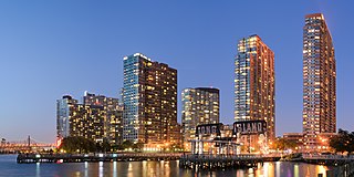
Long Island City (LIC) is a residential and commercial neighborhood on the extreme western tip of Queens, New York City, on the western edge of Long Island. It is bordered by Astoria to the north; the East River to the west; Hazen Street, 49th Street, and New Calvary Cemetery in Sunnyside to the east; and Newtown Creek—which separates Queens from Greenpoint, Brooklyn—to the south.

St. Albans is a residential middle class community in the southeastern portion of the New York City borough of Queens. It is bordered by Jamaica to the northwest, Hollis to the north, Queens Village to the northeast, Cambria Heights to the east, Laurelton to the southeast, Springfield Gardens to the south, and South Jamaica to the southwest. St. Albans is centered on the intersection of Linden Boulevard and Farmers Boulevard, about two miles north of John F. Kennedy International Airport.

Corona is a neighborhood in the borough of Queens in New York City. It is bordered by Flushing and Flushing Meadows–Corona Park to the east, Jackson Heights to the west, Forest Hills and Rego Park to the south, Elmhurst to the southwest, and East Elmhurst to the north. Corona's main thoroughfares include Corona Avenue, Roosevelt Avenue, Northern Boulevard, Junction Boulevard, and 108th Street.

Elmhurst is a neighborhood in the borough of Queens in New York City. It is bounded by Roosevelt Avenue on the north; the Long Island Expressway on the south; Junction Boulevard on the east; and the New York Connecting Railroad on the west.

Jackson Heights is a neighborhood in the northwestern portion of the borough of Queens in New York City. Jackson Heights is neighbored by North Corona to the east, Elmhurst to the south, Woodside to the west, northern Astoria (Ditmars-Steinway) to the northwest, and East Elmhurst to the northeast. Jackson Heights has an ethnically diverse community, with half the population having being foreign-born since the 2000s. According to the 2010 United States Census, the neighborhood has a population of 108,152.

Jamaica is a middle-class neighborhood in the New York City borough of Queens. It is mainly composed of a large commercial and retail area, though part of the neighborhood is also residential. Jamaica is bordered by Hollis to the east; St. Albans, Springfield Gardens, Rochdale Village to the southeast; South Jamaica to the south; Richmond Hill and South Ozone Park to the west; Briarwood to the northwest; and Kew Gardens Hills, Jamaica Hills, and Jamaica Estates to the north.

Hollis is a residential middle-class neighborhood within the southeastern section of the New York City borough of Queens. While a predominantly African-American community, there are small minorities of Hispanics and South Asians residing in the area. Boundaries are considered to be 181st Street to the west, Hillside Avenue to the north, Francis Lewis Boulevard to the east, and Murdock Avenue to the south. Hollis is located between Jamaica to the west and Queens Village to the east.

Queens Village is a mostly residential middle class neighborhood in the eastern part of the New York City borough of Queens. It is bound by Hollis to the west, Cambria Heights to the south, the town of New Hyde Park to the east, and Oakland Gardens to the north.

Rosedale is a neighborhood in New York City in the southeastern portion of the borough of Queens. The neighborhood, located along the southern part of Long Island, borders Nassau County.
South Jamaica is a residential neighborhood in the borough of Queens in New York City, located south of downtown Jamaica. Although a proper border has not been established, the neighborhood is a subsection of greater Jamaica bounded by the Long Island Rail Road Main Line tracks, Jamaica Avenue, or Liberty Avenue to the north; the Van Wyck Expressway on the west; Rockaway Boulevard on the south; and Merrick Boulevard on the east, adjoining the neighboring community of St. Albans. Other primary thoroughfares of South Jamaica include Baisley, Foch, Linden, Guy R. Brewer, and Sutphin Boulevards. The 180th Street Business Improvement District is responsible for the development of the area.
Laurelton is a largely middle-class neighborhood in the New York City borough of Queens and part of the former town of Jamaica. Merrick Boulevard, which bisects the community in a generally east–west direction, forms its commercial spine. It is bounded by Springfield Boulevard to the west, 121st Avenue to the north, Laurelton Parkway to the east, and Conduit Avenue to the south.

Cambria Heights is a residential neighborhood in the southeastern portion of the New York City borough of Queens. It is bounded by Springfield Boulevard and Francis Lewis Boulevard to the west, the Elmont, Nassau County border on the east, Queens Village to the north, St. Albans to the west, and Montefiore Cemetery and Laurelton, Springfield Gardens and Rosedale to the south. As of 2010, Cambria Heights's population was 18,677. The neighborhood is part of Queens Community Board 13.

Hamilton Heights is a neighborhood in the northern part of Manhattan in New York City. It is the northernmost part of the West Harlem area, along with Manhattanville and Morningside Heights to its south, and it contains the sub-neighborhood and historic district of Sugar Hill. Washington Heights lies to Hamilton Heights' north, and to its east is Central Harlem.

East Elmhurst is a residential neighborhood in the northwest section of the New York City borough of Queens. It is bounded to the south by Jackson Heights and Corona, to the north and east by Bowery Bay, and to the west by Woodside and Ditmars Steinway. The area includes LaGuardia Airport, located on the shore of Flushing Bay, and Astoria Heights.

South Ozone Park is a neighborhood in the southwestern section of the New York City borough of Queens. It is just north of John F. Kennedy International Airport, between Aqueduct Racetrack to the west and the Van Wyck Expressway to the east. Adjacent neighborhoods include Ozone Park to the west; Richmond Hill to the north; Jamaica, South Jamaica, and Springfield Gardens to the east; and Howard Beach and Old Howard Beach to the southwest.
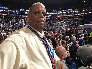
Leroy George Comrie, Jr. is an American politician from New York City. He represents District 14 in the New York State Senate, which comprises St. Albans, Cambria Heights, Jamaica, Hollis, Rosedale, Laurelton, Kew Gardens, Queens Village and other neighborhoods within the borough of Queens.

The Q27 bus route constitutes a public transit line in Queens, New York City, running primarily along 46th Avenue, Rocky Hill Road and Springfield Boulevard between a major bus-subway hub in Flushing and Cambria Heights. The route is operated by MTA Regional Bus Operations under the New York City Transit brand.

Queens Gateway to Health Sciences Secondary School is a school in the New York City borough of Queens which places emphasis on the health sciences. The school serves grades 6–12. Previously co-located in other school buildings, the school moved to its current building for the 2010–11 school year.
The Queens Community Board 13 is a local government in the New York City borough of Queens, encompassing the neighborhoods of Queens Village, Glen Oaks, Bellerose, Cambria Heights, Laurelton, Rosedale, Meadowmere, Floral Park and Brookville. It is bounded to the north by the Grand Central Parkway, to the east by the Nassau County border, to the south by Nassau County and John F. Kennedy International Airport and to the west by Francis Lewis Boulevard. The area has a population of 196,284, which is made up of roughly 60% Black, 10% Caucasian, 12% Asian and 12% Hispanic residents.

Newcomers High School is a high school located in Long Island City, Queens, New York City, United States. It opened in 1995 with Lourdes Burrows as its principal; Orlando Sarmiento is the most recent principal, and was appointed in 2009. This school specializes in introducing new immigrants to American culture, and also teaching English to students. In 2009, it was rated as #6 out of U.S. News & World Report's list of top 500 high schools in the U.S.—making it the highest-ranked school out of 12 New York City public schools on the top 500 list. The school is near the Queens Plaza and Queensboro Plaza New York City Subway stations, as well as numerous MTA Bus/New York City Bus routes.