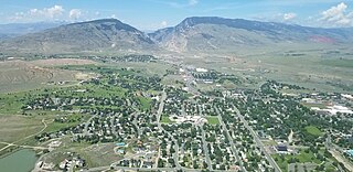
Cody is a city in Northwest Wyoming and the seat of government of Park County, Wyoming, United States. It is named after Buffalo Bill Cody for his part in the founding of Cody in 1896.

Granada is a city in western Nicaragua and the capital of the Granada Department. With an estimated population of 105,862 (2022), it is Nicaragua's ninth most populous city. Granada is historically one of Nicaragua's most important cities, economically and politically. It has a rich colonial heritage, seen in its architecture and structure.
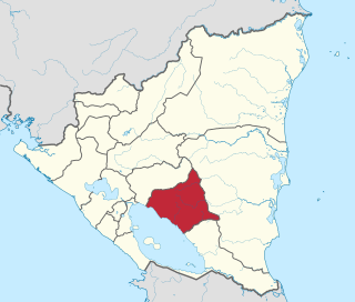
Chontales is a department in Nicaragua. It covers an area of 6,481 km² and has a population of 191,856. The capital is Juigalpa. Some 90 kilometres (56 mi) of land overlooks Lake Cocibolca on the western side. The department is livestock and fishing based, and is also a producer of apples.

Monte Plata is an eastern province of the Dominican Republic, and also the name of its capital city. It was split from San Cristóbal in 1992.

Nicaraguans are people inhabiting in, originating or having significant heritage from Nicaragua. Most Nicaraguans live in Nicaragua, although there is also a significant Nicaraguan diaspora, particularly in Costa Rica and the United States with smaller communities in other countries around the world. There are also people living in Nicaragua who are not Nicaraguans because they were not born or raised in Nicaragua nor have they gained citizenship.

Boaco is the capital city and a municipality of the Boaco Department of Nicaragua. The municipality of Boaco has a population of 63,422 and an area of 1,087 km2 while the department (state) is 4,177 km2.

Antiguo Cuscatlán(colloquially known as Antiguo) is a municipality in the La Libertad department of El Salvador, and its eastern tip lays in San Salvador Department part of the Metropolitan Area of San Salvador, southwest of San Salvador and southeast of Santa Tecla. The population was 48,027 at the 2010 census. Antiguo Cuscatlán can be translated as Old Jeweled City: Antiguo means ancient or old in Spanish, and Cuscatlán means jeweled city in Nahuat. The city used to be the capital of the Pipil or Cuzcatecs, before the Spanish conquest of the New World.
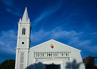
Teustepe is a municipality in the Boaco department of Nicaragua. It has a population of 26,800 and an extension of 645.73 km2. The capital is the town of Teustepe, 94 km. from Managua with a population of 3,500.
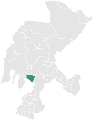
San José de los Remates is a municipality in the Boaco department of Nicaragua.
San Lorenzo is a municipality in the Boaco Department of Nicaragua. It has a population of 28,100 and an extension of 559.61 km2. The economy is based mainly on agricultural and some agropecuarian activities. The capital is the town of San Lorenzo located 91 km from Managua.
Santa Lucía is a municipality in the Boaco department of Nicaragua. It has a population of 10,300 and an extension of 120.78 km2. The capital is the town of Santa Lucía located 94 km from Managua. Approx. 72% of the population lives in rural areas and 28% in the urban zones.

Tipitapa is a city and municipality in the Managua department of western Nicaragua. The area is located between Lake Managua and Lake Nicaragua.
Quilalí is a town and a municipality in the Nueva Segovia Department of Nicaragua.
Morrito is a municipality in the Río San Juan department of Nicaragua. As of 2018 the current mayor is Eda Griselda Medina.

Catalão is a city and municipality located in the south of the state of Goiás, in Brazil. It is a large producer of grains, cattle, and phosphates and has a John Deere and Mitsubishi factory.

Palmelo is municipality in southeast Goiás state, Brazil. It is the smallest municipality in the state and the only town in Brazil where most of the inhabitants follow the religion called Spiritism.
The municipality of Tepetongo is located in the southwestern portion of the Mexican state of Zacatecas. It is a town on the border between Zacatecas and Jalisco. It is next to Huejucar and Jerez de García Salinas
Janaúba is a municipality in the north of the Brazilian state of Minas Gerais. In 2020 the population was 72,018 in a total area of 2,189 km2. The elevation is 692 meters above sea level.
Tonaya is a town and municipality, in Jalisco in central-western Mexico. The municipality covers an area of 293.6 km2.

Santa María Tonameca is a town and municipality located on the southern coast of Oaxaca, Mexico, about 268 km from the capital city of Oaxaca. It is part of the Pochutla District in the east of the Costa Region. It is a very rural area, which is best known for the beach communities of Mazunte, San Agustinillo and La Ventanilla. The National Turtle Center, a research center and aquarium is located in Mazunte, along with conservation centers for butterflies and iguanas. The town itself is the site of the largest annual festival in the area, celebrating the rescue of a cedar image of the Virgin Mary from the rubble of the town church after an earthquake on 11 May 1870.


