
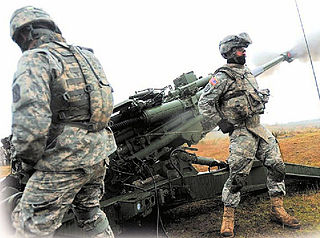
Fort Novosel is a United States Army post located primarily in Dale County, Alabama, United States. It is named in honor of Chief Warrant Officer Michael J. Novosel, an Army aviator and Medal of Honor recipient. It was previously named for a Civil War officer, Confederate Colonel Edmund Rucker. The post is the primary flight training installation for U.S. Army Aviators and is home to the United States Army Aviation Center of Excellence (USAACE) and the United States Army Aviation Museum. Small sections of the post also lie in Coffee, Geneva, and Houston counties. Part of the Dale County section of the base is a census-designated place; its population was 4,636 at the 2010 census.

Fort Carson is a United States Army post located directly south of Colorado Springs in El Paso, Pueblo, Fremont, and Huerfano counties, Colorado, United States. The developed portion of Fort Carson is located near the City of Colorado Springs in El Paso County.
Fort Lewis is a United States Army base located 9.1 miles (14.6 km) south-southwest of Tacoma, Washington. Fort Lewis was merged with McChord Air Force Base on February 1, 2010, to form Joint Base Lewis–McChord.

Camp Shelby is a military post whose South Gate is located at the southern boundary of Hattiesburg, Mississippi, on U.S. Highway 49. It is the largest state-owned training site in the nation. During wartime, the camp's mission is to serve as a major independent mobilization station of the United States Army Forces Command (FORSCOM). Camp Shelby Joint Forces Training Center is the largest reserve component training site, covering 136,000 acres (550 km2), allowing up to battalion-level maneuver training, Gunnery Table 8-12, field artillery firing points and a wide range of support facilities. This is the normal Annual Training location for National Guard and Reserve units located in Mississippi, Alabama, and Tennessee. However, units from across the country use its assets to support a variety of missions. The 2nd Battalion, 114th Field Artillery conducts its gunnery training and has the bulk of its combat equipment stored in the Mobilization and Annual Training Equipment Site (MATES) located there.
Camp Ripley is a 53,000-acre (210 km2) military and civilian training facility operated by the Minnesota National Guard near the city of Little Falls in the central part of the state. The location of the camp was selected in 1929 by Ellard A. Walsh, Adjutant General of the State of Minnesota. The site's winter warfare training course is the primary facility used by the National Guard for winter combat exercises. Camp Ripley also hosts the training academy for the Minnesota State Patrol and is a popular site for athletes training to compete in winter biathlons. Most Minnesota Guard soldiers train at Camp Ripley during two-week annual training periods.

Fort Barfoot, formerly Fort Pickett, is a Virginia Army National Guard installation, located near the town of Blackstone, Virginia. Home of the Army National Guard Maneuver Training Center, Fort Barfoot was originally named for the United States Army officer and Confederate General George Pickett. It was one of the U.S. Army installations named for Confederate soldiers that has been renamed by The Naming Commission. Their recommendation was for the post to be renamed Fort Barfoot, in honor of Medal of Honor recipient Colonel Van T. Barfoot. On 5 January 2023, William A. LaPlante, US Under Secretary of Defense for Acquisition and Sustainment, directed the full implementation of the recommendations of the Naming Commission, DoD-wide. The redesignation ceremony occurred on 24 March 2023.

The West Virginia National Guard is a part of the West Virginia Department of Military Affairs and Public Safety. It comprises the West Virginia Army National Guard and the West Virginia Air National Guard. Unlike some states, West Virginia does not maintain a state defense force, nor is there a naval component to the state's military forces.

Fort McClellan, originally Camp McClellan, is a decommissioned United States Army post located adjacent to the city of Anniston, Alabama. During World War II, it was one of the largest U.S. Army installations, training an estimated half-million troops. After the war it became the home of the Military Police Corps, the Chemical Corps and the Women's Army Corps. From 1975 and until it was closed in 1999, Fort McClellan was home of the Military Police Corps and the One Station Unit Training (OSUT) Military Police School. Also after World War II and until it was closed in 1999, it was home of the Chemical Corps School, which trained soldiers in chemical warfare. In 1988, Fort McClellan was used as an alternate training academy for the United States Border Patrol. Before its closure by the Base Realignment and Closure commission (BRAC), the post employed about 10,000 military personnel and about 1,500 civilians. It underwent unexploded ordnance (UXO) clean up from 2003 to 2014. Since 2010, about 3,000 acres of the post's brownfield land have been redeveloped as a mixed-use community.

Camp Blanding Joint Training Center is the primary military reservation and training base for the Florida National Guard, both the Florida Army National Guard and certain nonflying activities of the Florida Air National Guard. The installation is located in Clay County, Florida, near the city of Starke. The site measures about 73,000 acres (30,000 ha) and includes Kingsley Lake. It also hosts other Reserve, Army National Guard, Air National Guard, and some Active Component training for the U.S. Armed Forces.

Dale Mabry Field is a former airport 3.4 miles west of Tallahassee, Florida. It was replaced in 1961 by Tallahassee Municipal Airport and the land is now the campus of Tallahassee Community College. Some of the runways are used for parking.

Fort Indiantown Gap, also referred to as "The Gap" or "FIG", is a census-designated place and National Guard Training Center primarily located in Lebanon County, Pennsylvania, United States. A portion of the installation is located in eastern Dauphin County. It is located adjacent to Interstate 81, 23 miles (37 km) northeast of Harrisburg, just north of the northern terminus of Pennsylvania Route 934 at I-81's Exit 85.

Camp Edwards is a United States military training installation located in western Cape Cod in Barnstable County, Massachusetts. It was named after Major General Clarence Edwards, commander of the 26th Division in World War I. The base is currently the home of portions of the 3rd Battalion, 126th Aviation Regiment, of the Massachusetts Army National Guard.

The Yakima Training Center (YTC) is a United States Army training center, used for maneuver training, Land Warrior system testing and as a live fire exercise area. It is located in the south central portion of the U.S. state of Washington, bounded on the west by Interstate 82, on the south by the city of Yakima, on the north by the city of Ellensburg and Interstate 90, and on the east by the Columbia River. It is a part of Joint Base Lewis-McChord. It comprises 327,000 acres of land, most of which consists of shrub-steppe, making it one of the largest areas of shrub-steppe habitat remaining in Washington state. The terrain is undulating and dominated by three east-west parallel ridges, the Saddle Mountains, Manastash Ridge, and Umtanum Ridge anticlines, which are part of the Yakima Fold Belt near the western edge of the Columbia River Plateau. Vegetation consists of sagebrush, bitterbrush, and bunch grass. Vagabond Army Airfield and Selah Airstrip are located on the Yakima Training Center. The training center is also used by the Japan Ground Self-Defense Force for exercises.

Camp Gruber is an Oklahoma Army National Guard (OKARNG) training facility. It covers a total of 87 square miles (230 km2).

Camp W. G. Williams, commonly known as Camp Williams, also known as Army Garrison Camp Williams, is a National Guard training site operated by the Utah National Guard. It is located south of Bluffdale, west of Lehi, and north of Saratoga Springs and Cedar Fort, approximately 25 miles (40 km) south of Salt Lake City, straddling the border between Salt Lake County and Utah County in the western portion of the Traverse Mountains. Camp Williams is also home to the Non-Commissioned Officer's Basic Leader Course, which is taught to Active, National Guard, and Reserve components.

Macon Downtown Airport is a city-owned public-use airport located three nautical miles southeast of the central business district of Macon, in Bibb County, Georgia, United States. It is also known as Herbert Smart Downtown Airport. The airport is included in the FAA's National Plan of Integrated Airport Systems for 2011–2015, which categorized it as a general aviation facility. It has no scheduled commercial airline service.
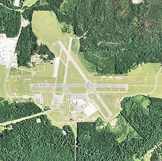
Esler Field, also known as Esler Regional Airport, is a military and public use airfield in Rapides Parish, Louisiana, United States, near the City of Pineville. It is located 10 nautical miles northeast of the central business district of Alexandria, Louisiana, The airfield is owned by the Louisiana Army National Guard and is the home of Army Aviation Support Facility #2 (AASF#2).
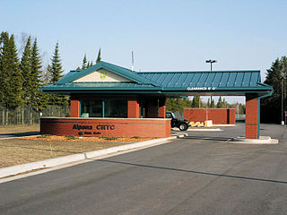
Alpena Combat Readiness Training Center is a Michigan Air National Guard training facility. It is located 7.1 miles (11.4 km) west-northwest of Alpena, Michigan.


