Campbell Island, New Zealand

Last updated

Campbell Island / Motu Ihupuku
Campbell3.jpg
Six Foot Lake, on Campbell Island / Motu Ihupuku
Campbell Island New Zealand geographic map en.svg
Map of Campbell Island / Motu Ihupuku
Pacific Ocean laea relief location map.jpg
Red pog.svg
Campbell Island / Motu Ihupuku
Location of Campbell Island / Motu Ihupuku in the Pacific
Etymology Robert Campbell
Geography
Location Pacific Ocean
Coordinates 52°32′24″S169°8′42″E / 52.54000°S 169.14500°E / -52.54000; 169.14500
Archipelago Campbell Islands
Area112.68 km2 (43.51 sq mi)
Highest elevation569 m (1867 ft)
Highest point Mount Honey
Administration
New Zealand
Demographics
Population0
Additional information
Time zone
  Summer (DST)
UN/LOCODE: TF

Campbell Island / Motu Ihupuku is an uninhabited subantarctic island of New Zealand, and the main island of the Campbell Island group. It covers 112.68 square kilometres (43.51 sq mi) of the group's 113.31 km2 (43.75 sq mi), and is surrounded by numerous stacks, rocks and islets like Dent Island, Folly Island (or Folly Islands), Isle de Jeanette-Marie, and Jacquemart Island, the latter being the southernmost extremity of New Zealand. The island is mountainous, rising to over 500 metres (1,640 ft) in the south. A long fiord, Perseverance Harbour, nearly bisects it, opening out to sea on the east coast.

Contents

The island is listed with the New Zealand Outlying Islands. The island is an immediate part of New Zealand, but not part of any region or district, but instead Area Outside Territorial Authority, like all other outlying islands, other than the Solander Islands. It is the closest piece of land to the antipodal point of the United Kingdom and Ireland, and the city furthest away is Limerick, Ireland.[ citation needed ]

Campbell Island is a UNESCO World Heritage Site.

History

Campbell Island / Motu Ihupuku as viewed from the International Space Station Campbell Island from ISS.jpg
Campbell Island / Motu Ihupuku as viewed from the International Space Station

Campbell Island was discovered in 1810 by Captain Frederick Hasselborough of the sealing brig Perseverance, which was owned by shipowner Robert Campbell's Sydney-based company Campbell & Co. (whence the island's name). [1] Captain Hasselborough drowned on 4 November 1810 in Perseverance Harbour on the south of the island, along with a young woman and a boy.[ citation needed ]

The island became a seal hunting base, and the seal population was almost totally eradicated. The first sealing boom was over by the mid-1810s. The second was a brief revival in the 1820s. The sealing era lasted from 1810 till 1912 during which time 49 vessels are recorded visiting for sealing purposes, one of which was lost off the coast. [2]

The whaling boom extended here in the 1830s and '40s. In 1874, the island was visited by a French scientific expedition intending to view the transit of Venus. Much of the island's topography is named after aspects of, or people connected with, the expedition.

Chart of South Harbour, Campbell Island, 1840, by J.E. Davis, master P239 Voyage of Discovery Ross Vol 1.jpg
Chart of South Harbour, Campbell Island, 1840, by J.E. Davis, master

In December 1840 Campbell Island was the last landfall before the Ross expedition explored the Antarctic. [3]

In 1883 the American schooner Sarah W. Hunt, a whaler, was near Campbell Island. Twelve men in two small whaleboats headed for the island in terrible weather looking for seals. One of the boats disappeared, and the other boat with six men aboard managed to make it ashore. Sanford Miner, the captain of the Sarah W. Hunt, assumed all the whalers were lost, and sailed away to Lyttelton, New Zealand. Fortunately for the stranded whalers, a seal protection boat, the Kekeno, happened to arrive at the island, and rescued the castaways. The captain's behaviour caused an international scandal. [4]

In the late 19th century, the island became a pastoral lease. Sheep farming was undertaken from 1896 until the lease, along with the sheep and a small herd of cattle, was abandoned in 1931 because of the Great Depression. [5]

In 1907, a group of scientists spent eight days on the island group surveying. The 1907 Sub-Antarctic Islands Scientific Expedition conducted a magnetic survey and also took botanical, zoological and geological specimens.

During World War II, a coastwatching station was operative at Tucker Cove at the north shore of Perseverance Harbour as part of the Cape Expedition program.

In 1992, a Campbell Island scene was incorporated into the reverse side design of the New Zealand five-dollar note in the fifth series of New Zealand bank notes. The scene includes a yellow-eyed penguin or hoiho (Megadyptes antipodes), a subantarctic lily ( Bulbinella rossii ), a daisy ( Pleurophyllum speciosum ), and bull kelp or rimurapa ( Durvillaea antarctica ). [6]

Following the passage of the Ngāi Tahu Claims Settlement Act 1998, the name of the island was officially altered to Campbell Island / Motu Ihupuku. [7]

An amateur radio DXpedition organised by the Hellenic Amateur Radio Association of Australia visited Campbell Island during November–December 2012. The team consisted of ten amateur radio operators from around the world, a NZ Department of Conservation Officer, and the ship's crew of six, including the captain, on the sailing vessel "Evohe". The ZL9HR DXpedition team made 42,922 on-air contacts during an eight-day operating period. [8]

Weather station

Campbell Island Automatic Weather Station
Baxter-Campbell-Island.jpg
Meteorological station at Beeman Cove (unmanned/automatic since 1995)
NZOffshoreIslandsMap.png
General information
TypeAutomatic weather station
Coordinates 52°33′04″S169°09′04″E / 52.550973°S 169.150981°E / -52.550973; 169.150981
Opened1946 (1946)
Owner MetService

After World War II, the coast watching station at Tucker Cove was converted for use as a meteorological station until the summer of 1958, when a new base was established at Beeman Cove, a few hundred metres further east. The new location provided improved exposure for the weather instruments, particularly wind recordings, and more modern accommodation for up to 12 full-time staff.

The new meteorological station (WMO ID 93944) at Beeman Cove was operated by the New Zealand Meteorological Service with ten full-time staff. Each team undertook 12-month expeditions to the island to undertake three hourly weather reports and twice daily radiosonde flights using hydrogen filled balloons. Weather reports were radioed back to New Zealand using HF radio to ZLW Wellington Radio. In addition to its primary purpose as a meteorological station, staff at the station also operated a seismic monitoring station, made measurements of the Earth's magnetic field, the ionosphere, and aurora australis, and undertook Albatross banding and whale counts of primarily Southern Right Whales for the New Zealand Wildlife Service.

In April 1992, staff of the weather station were snorkelling at Northwest Bay when one of them, Mike Fraser, was attacked by a great white shark some 30 metres (100 ft) offshore from the beach at Middle Bay. Fraser managed to return to shore with the assistance of one of his team, Jacinda Amey, after suffering severe lacerations to both his arms. The team kept Fraser alive at the bay—some four kilometres (2.5 mi) from the main base—while a rescue helicopter from Taupō was called and made an emergency flight to the island to repatriate him to Invercargill Hospital. This was the longest ever single-engine helicopter rescue in the world. [9] Jacinda Amey was awarded the New Zealand Cross—the highest bravery medal for civilians—for assisting the injured team member from the water. [10] The rescue helicopter pilot, John Funnell, was awarded the New Zealand Bravery Medal. [11]

In 1995, station staff were permanently withdrawn when the manual weather observation programme was replaced by an automated weather station, and the upper air soundings ceased. Today periodic visits to the island are undertaken by Meteorological Service staff to maintain the weather station on Royal New Zealand Navy vessels, which also transport conservation staff undertaking field research. Other visitors to the island include occasional summer time eco-tourism cruises.

In May 2018, scientists in New Zealand documented what they believe is the largest wave ever recorded in the Southern Hemisphere to date. The 23.8-metre (78 ft) wave was measured by a weather buoy near the island. [12]

The legend of The Lady of the Heather

The Lady of the Heather is the title of a 1945 romantic novel by Will Lawson. The novel is a mixture of facts and fiction elaborating on the incidents surrounding Captain Hasselburg's death on Campbell Island. The story is about a daughter of Bonnie Prince Charlie, exiled to Campbell Island after she is suspected of treachery to the Jacobite cause. [13] Her character was inspired by Elizabeth Farr. [14] Farr was probably what would now be called a "ship girl", but the presence of a European woman at this remote place, and her death, gave rise to The Lady of the Heather story. [15]

The accident happened when William Tucker was present on the Aurora. Tucker was another unusual character in the sealing era who became the source of a legend and a novel. [16] The remoteness and striking appearance of the sealing grounds, whether on mainland New Zealand or the subantarctic islands, and the sealing era's early place in Australasia's European history, supply the elements for romance and legend which are generally absent in the area's colonial history.

Climate

Campbell Island has a maritime tundra climate (Köppen ET). The island receives only 647 hours of bright sunshine annually and it can expect less than an hour's sunshine on 215 days (59%) of the year. The peaks of the island are frequently obscured by clouds. It has an annual rainfall of 1,329 millimetres (52.3 in), with rain, mainly light showers or drizzle (although it often snows in the winter and spring), falling on an average of 325 days a year. It is a windy place, with gusts of over 96 kilometres per hour (50 kn; 60 mph) occurring on at least 100 days each year. Variations in daily and annual temperatures are small with a mean annual temperature of 7 °C (44.6 °F), rarely rising above 12.1 °C (53.8 °F). The warmest temperature ever recorded was 21.2 °C (70.2 °F) and the coldest was −7.9 °C (17.8 °F). [17]

Climate data for Campbell Island (1991–2020 normals)
MonthJanFebMarAprMayJunJulAugSepOctNovDecYear
Record high °C (°F)21.2
(70.2)
19.3
(66.7)
16.1
(61.0)
15.8
(60.4)
12.4
(54.3)
11.3
(52.3)
10.3
(50.5)
10.4
(50.7)
12.7
(54.9)
15.4
(59.7)
18.3
(64.9)
20.0
(68.0)
21.2
(70.2)
Mean daily maximum °C (°F)12.0
(53.6)
11.8
(53.2)
10.9
(51.6)
9.6
(49.3)
8.4
(47.1)
7.1
(44.8)
7.0
(44.6)
7.4
(45.3)
7.9
(46.2)
8.8
(47.8)
9.8
(49.6)
11.5
(52.7)
9.4
(48.9)
Daily mean °C (°F)9.6
(49.3)
9.5
(49.1)
8.8
(47.8)
7.7
(45.9)
6.5
(43.7)
5.0
(41.0)
5.1
(41.2)
5.3
(41.5)
5.7
(42.3)
6.3
(43.3)
7.2
(45.0)
8.9
(48.0)
7.1
(44.8)
Mean daily minimum °C (°F)7.2
(45.0)
7.2
(45.0)
6.7
(44.1)
5.7
(42.3)
4.5
(40.1)
3.0
(37.4)
3.2
(37.8)
3.2
(37.8)
3.6
(38.5)
3.9
(39.0)
4.7
(40.5)
6.4
(43.5)
4.9
(40.8)
Record low °C (°F)2.9
(37.2)
2.3
(36.1)
0.5
(32.9)
0.0
(32.0)
−3.2
(26.2)
−6.5
(20.3)
−7.9
(17.8)
−6.4
(20.5)
−4.2
(24.4)
−1.4
(29.5)
−1.2
(29.8)
3.2
(37.8)
−7.9
(17.8)
Average precipitation mm (inches)124.7
(4.91)
102.2
(4.02)
124.1
(4.89)
121.1
(4.77)
133.6
(5.26)
113.6
(4.47)
115.0
(4.53)
108.1
(4.26)
112.9
(4.44)
114.3
(4.50)
118.1
(4.65)
114.6
(4.51)
1,402.3
(55.21)
Average precipitation days (≥ 1.0 mm)18.817.520.319.322.622.222.821.620.622.219.618.5246.2
Mean monthly sunshine hours 74.872.466.448.639.429.231.334.552.263.462.972.2647.3
Source 1: NOAA [18]
Source 2: NIWA National Climate Database (sunshine and extremes) [19]

Flora and fauna

Important Bird Area

Campbell Island is the most important breeding area of the southern royal albatross. The island is part of the Campbell Island group Important Bird Area (IBA), identified as such by BirdLife International because of its significance as a breeding site for several species of seabirds as well as the endemic Campbell teal and Campbell snipe. [20] Campbell Island also hosts numerous penguin species that breed on the island, including the yellow-eyed penguin, the rockhopper penguin, and the erect-crested penguin. [21] Other albatross species breed on the island as well, such as the endemic Campbell black-browed albatross, a few pairs of Antipodean albatross, the light-mantled sooty albatross, Black-browed mollymawk and the grey-headed mollymawk. [21] Other bird species that breed on the island include the sooty shearwater, the grey petrel, the white-chinned petrel, the endemic Campbell Island shag, the grey duck, the southern skua, the southern black-backed gull, the red-billed gull, the Antarctic tern, the song thrush, the Common blackbird, the Dunnock (Hedge sparrow), the New Zealand pipit, the white-eye, the lesser redpoll, the chaffinch, and the starling. [22]

World's most remote tree

Campbell Island is home to what is believed to be the world's most remote tree – a solitary Sitka spruce, more than 100 years old. The nearest tree is over 222 kilometres (138 mi) away on the Auckland Islands. [23] [24] [25] The tree is believed to have been introduced by Lord Ranfurly between 1901 and 1907. [26] Australian academics have proposed designating the tree as a golden-spike signal-marker for the start of the anthropocene epoch. [27]

Conservation

In 1954, the island was gazetted as a nature reserve. Feral Campbell Island cattle were eliminated by about 1984, and feral Campbell Island sheep were culled during the 1970s and 1980s, with their eventual extermination in 1992. In 2001, brown rats (Norway rats) were eradicated from the island nearly 200 years after their introduction. This was the world's largest rat eradication programme. The island's rat-free status was confirmed in 2003. [17] Since the eradication, vegetation and invertebrates have been recovering, seabirds have been returning and the Campbell teal, the world's rarest duck, has been reintroduced. An undescribed Cyanoramphus parakeet was discovered (in fossil bones) in 2004, along with evidence of a falcon or harrier. [28] Banded dotterel (Charadrius bicinctus) are also believed to have inhabited the island at one point. [29] Other native landbirds include the New Zealand pipit and the Campbell snipe, a race of the Subantarctic snipe, Coenocorypha aucklandica , described race perseverance. It was discovered only in 1997 on a tiny rat-free island off the south coast, Jacqeumart Island. The snipe had survived there and began recolonising the main island after the rats had been removed.

Marine mammals have shown gradual recovery in the past decades. Sea lions and southern elephant seals have begun to re-colonize the island. [30] Some southern right whales still come into bays in the winter to winter or calve, most notably at Northwest Bay and Perseverance Harbour, [31] but in much smaller number than in the Auckland Islands. [32] Historically, fin whales used to inhabit close to shore. [33]

The area is one of five subantarctic island groups designated as a World Heritage Site by UNESCO. [34]

Geology

Campbell Island is an extinct alkaline shield volcano that marine erosion has worn down into its present shape. [35] [36] The volcano has been extinct for some six million years, and glacial ice cover prevented vegetation from growing on the island until approximately 15,000 years ago. [37] Basalt, hawaiite, mugearite and trachyte are the dominant volcanic rocks comprising Campbell Island. They were erupted between 6.5 and 11 million years ago during the Miocene epoch. [36] The island is considered to be part of the submerged continent of Zealandia.

Research

During World War II, the New Zealand government had coastal watchers on the island with trained naturalists who made observations of the geology, flora, and fauna of Campbell Island. [38]

To mark the 200th anniversary of its discovery, the Campbell Island Bicentennial Expedition (CIBE) was undertaken from December 2010 to February 2011. The research expedition was the largest multidisciplinary expedition to the island in over 20 years, and aimed to document the island's human history, assess recovery of the island's flora and invertebrate fauna since the removal of sheep and the world's largest rat eradication programme, study the island's plentiful but little understood streams and characterise the unusual stream fauna, and reconstruct past environmental conditions and deduce long term climate change from tarn sediment cores.

The expedition was run by the 50 Degrees South Trust, a charitable organisation established to further research and education on New Zealand's Subantarctic Islands, and to support the preservation and management of these World Heritage ecosystems. The expedition and the programme outputs can be followed at the CIBE website.

See also

Related Research Articles

<span class="mw-page-title-main">South Georgia and the South Sandwich Islands</span> British Overseas Territory in the South Atlantic

South Georgia and the South Sandwich Islands (SGSSI) is a British Overseas Territory in the southern Atlantic Ocean. It is a remote and inhospitable collection of islands, consisting of South Georgia and a chain of smaller islands known as the South Sandwich Islands. South Georgia is 165 kilometres (103 mi) long and 35 kilometres (22 mi) wide and is by far the largest island in the territory. The South Sandwich Islands lie about 700 kilometres (430 mi) southeast of South Georgia. The territory's total land area is 3,903 km2 (1,507 sq mi). The Falkland Islands are about 1,300 kilometres (810 mi) west from its nearest point.

<span class="mw-page-title-main">Auckland Islands</span> Volcanic archipelago in New Zealand

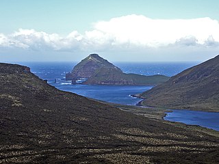
The Auckland Islands are an archipelago of New Zealand, lying 465 km (289 mi) south of the South Island. The main Auckland Island, occupying 460 km2 (180 sq mi), is surrounded by smaller Adams Island, Enderby Island, Disappointment Island, Ewing Island, Rose Island, Dundas Island, and Green Island, with a combined area of 570 km2 (220 sq mi). The islands have no permanent human inhabitants.

<span class="mw-page-title-main">Macquarie Island</span> Sub-Antarctic island of Australia

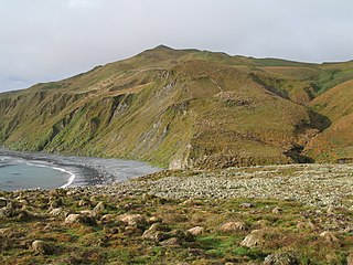
Macquarie Island is an island in the southwestern Pacific Ocean, about halfway between New Zealand and Antarctica. Regionally part of Oceania and politically a part of Tasmania, Australia, since 1900, it became a Tasmanian State Reserve in 1978 and was inscribed as a UNESCO World Heritage Site in 1997.

<span class="mw-page-title-main">Auckland Island</span> Island off Southern New Zealand

Auckland Island is the main island of the eponymous uninhabited archipelago in the Pacific Ocean. It is part of the New Zealand subantarctic area. It is inscribed in the UNESCO World Heritage list together with the other New Zealand Subantarctic Islands in the region.

<span class="mw-page-title-main">South Georgia</span> Island in the South Atlantic Ocean

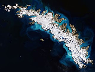
South Georgia is an island in the South Atlantic Ocean that is part of the British Overseas Territory of South Georgia and the South Sandwich Islands. It lies around 1,400 kilometres (870 mi) east of the Falkland Islands. Stretching in the east–west direction, South Georgia is around 170 kilometres (106 mi) long and has a maximum width of 35 kilometres (22 mi). The terrain is mountainous, with the central ridge rising to 2,935 metres (9,629 ft) at Mount Paget. The northern coast is indented with numerous bays and fjords, serving as good harbours.

<span class="mw-page-title-main">Prince Edward Islands</span> Two small sub-Antarctic islands belonging to South Africa

The Prince Edward Islands are two small uninhabited islands in the sub-Antarctic Indian Ocean that are administered by South Africa. They are named Marion Island and Prince Edward Island.

<span class="mw-page-title-main">Crozet Islands</span> Archipelago in the subantarctic French territories

The Crozet Islands are a sub-Antarctic archipelago of small islands in the southern Indian Ocean. They form one of the five administrative districts of the French Southern and Antarctic Lands.

<span class="mw-page-title-main">Île Amsterdam</span> Island in the southern Indian Ocean

Île Amsterdam, also known as Amsterdam Island and New Amsterdam (Nouvelle-Amsterdam), is an island of the French Southern and Antarctic Lands in the southern Indian Ocean that together with neighbouring Île Saint-Paul 90 km to the south forms one of the five districts of the territory.

<span class="mw-page-title-main">Gough Island</span> Island in the South Atlantic

Gough Island, also known historically as Gonçalo Álvares, is a rugged volcanic island in the South Atlantic Ocean. It is a dependency of Tristan da Cunha and part of the British overseas territory of Saint Helena, Ascension and Tristan da Cunha. It is approximately 400 km (250 mi) south-east of the Tristan da Cunha archipelago, 2,400 km (1,500 mi) north-east from South Georgia Island, 2,700 km (1,700 mi) west from Cape Town, and over 3,200 km (2,000 mi) from the nearest point of South America.

<span class="mw-page-title-main">Antipodes Islands</span> Subantarctic archipelago of New Zealand

The Antipodes Islands are inhospitable and uninhabited volcanic islands in subantarctic waters to the south of – and territorially part of – New Zealand. The 21 km2 (8.1 sq mi) archipelago lies 860 km (530 mi) to the southeast of Stewart Island/Rakiura, and 730 km (450 mi) to the northeast of Campbell Island. They are very close to being the antipodal point to Normandy in France, meaning that the city farthest away is Cherbourg-en-Cotentin, France.

<span class="mw-page-title-main">Bird Island, South Georgia</span> Antarctic base in SGSSI, United Kingdom

Bird Island is 4.8 kilometres (3 mi) long and 800 metres (875 yd) wide, separated from the western end of South Georgia by Bird Sound. It is part of the British overseas territory of South Georgia and the South Sandwich Islands, also claimed by Argentina as part of Tierra del Fuego province.

<span class="mw-page-title-main">Antipodes Subantarctic Islands tundra</span> Ecoregion

The Antipodes Subantarctic Islands tundra ecoregion, within the tundra biome, includes five remote island groups in the Pacific Ocean south of New Zealand: the Bounty Islands, Auckland Islands, Antipodes Islands and Campbell Island groups of New Zealand, and Macquarie Island of Australia.

<span class="mw-page-title-main">Jacquemart Island</span> Island in New Zealand

Jacquemart Island, one of the islets surrounding Campbell Island in New Zealand, lies 1 km south of Campbell Island and is the southernmost island of New Zealand.

<span class="mw-page-title-main">Dent Island, New Zealand</span> Subantarctic South Pacific rock

Dent Island is a subantarctic 26-hectare (64-acre) rock stack, lying 3 km west of Campbell Island and belonging to the Campbell Island group. Dent Island is located at 52°31.15′S169°3.75′E. It was named by the French 1874 Transit of Venus Expedition to Campbell Island because of its resemblance to a tooth.

<span class="mw-page-title-main">Campbell Islands</span> Island group in New Zealand

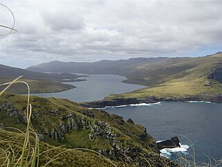
The Campbell Islands are a group of subantarctic islands, belonging to New Zealand. They lie about 600 km south of Stewart Island. The islands have a total area of 113 km2 (44 sq mi), consisting of one big island, Campbell Island, and several small islets, notably Dent Island, Isle de Jeanette Marie, Folly Island, Jacquemart Island, and Monowai Island. Ecologically, they are part of the Antipodes Subantarctic Islands tundra ecoregion. The islands are one of five subantarctic island groups collectively designated as a World Heritage Site by UNESCO.

<span class="mw-page-title-main">Enderby Island</span> Island of the New Zealand-administered Auckland group in the subantarctic South Pacific

Enderby Island is part of New Zealand's uninhabited Auckland Islands archipelago, south of mainland New Zealand. It is situated just off the northern tip of Auckland Island, the largest island in the archipelago.

<span class="mw-page-title-main">Folly Island, New Zealand</span> Subantarctic South Pacific island

Folly Island or the Folly Islands is a subantarctic island located in New Zealand's Campbell Island group.

<span class="mw-page-title-main">Bouvet Island</span> Uninhabited volcanic island and dependency of Norway in the South Atlantic Ocean

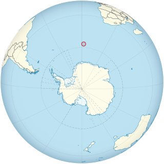
Bouvet Island is an island and dependency of Norway, and declared an uninhabited protected nature reserve. It is a subantarctic volcanic island, situated in the South Atlantic Ocean at the southern end of the Mid-Atlantic Ridge, and is the world's most remote island. It is not part of the southern region covered by the Antarctic Treaty System.

<span class="mw-page-title-main">Campbell snipe</span> Subspecies of bird

The Campbell snipe, also known as the Campbell Island snipe, is a rare subspecies of the Subantarctic snipe, endemic to Campbell Island, a subantarctic island south of New Zealand in the Southern Ocean. It was not formally described until January 2010. The subspecific name alludes to the name of the sealing brig Perseverance, captained by Frederick Hasselborough, that discovered Campbell Island in 1810, and which probably inadvertently introduced rats to the island when it was wrecked there in 1828.

<span class="mw-page-title-main">Île de la Possession</span> Largest and only inhabited Crozet Island

Île de la Possession, or Possession Island, formerly Île de la Prise de Possession, is part of the Subantarctic Crozet Archipelago. Administratively, it is part of the French Southern and Antarctic Lands. It is an important nesting site for seabirds.

References

  1. The Antarctic Dictionary
  2. R.K. Headland, Historical Antarctic Sealing Industry, Scott Polar Research Institute, University of Cambridge, 2018, p.166. ISBN   978-0-901021-26-7
  3. 1 2 Ross, James Clark (1847). A Voyage of Discovery and Research in the Southern and Antarctic Regions, during the Years 1839-43. Volume 1. John Murray. pp. 154–164.
  4. "The Sarah W. Hunt". Star. No. 4873. 12 December 1883. Retrieved 22 February 2017.
  5. Ian S. Kerr, Campbell Island, a History, Wellington: A.H. & A.W. Reed,1976.
  6. "Explaining New Zealand's Currency" (PDF). Reserve Bank of New Zealand. Archived from the original (PDF) on 30 April 2013. Retrieved 2 August 2013.
  7. "Ngai Tahu Claims Settlement Act 1998" . Retrieved 28 March 2016.
  8. "ZL9HR Callsign Page". QRZ Callsign Database. Archived from the original on 14 June 2012. Retrieved 5 May 2017.
  9. Quayle, T. (1995). "History of the Campbell Island Meteorological Station" (PDF). Weather and Climate. 15 (1). Meteorological Society of New Zealand: 7–9. doi:10.2307/44279875. JSTOR   44279875. Archived from the original (PDF) on 22 April 2017. Retrieved 30 April 2017.
  10. Recipients of the New Zealand Cross: Jacinda Margaret Amey – date of act: 24 April 1992; year of award: 1999
  11. Funnell, J. (4 October 2016)."Daring Adventures of a Search and Rescue Pilot". Radio New Zealand.
  12. "Massive wave is southern hemisphere record, scientists believe". BBC News . 11 May 2018. Retrieved 11 May 2018.
  13. "Tekeli-li" or Hollow Earth Lives: A Bibliography of Antarctic Fiction
  14. Tragic Drownings at Campbell Island, The Sealer's Shanty [ permanent dead link ]
  15. Lawson, Will, The Lady of the Heather, Angus and Robertson Ltd., Sydney & London 1945 (First Edition Oswald-Sealy (NZ) Ltd., )
  16. Peter Entwisle, Taka: a Vignette Life of William Tucker 1784-1817, Dunedin: Port Daniel Press, 2005, ISBN   0-473-10098-3, pp.73-75.
  17. 1 2 NZ Govt report on eradication of Norway rats
  18. "Campbell Island Climate Normals 1991–2020". National Oceanic and Atmospheric Administration. Archived from the original on 30 January 2024. Retrieved 30 January 2024.
  19. "NIWA National Climate Database".
  20. BirdLife International. (2012). Important Bird Areas factsheet: Campbell Island (and outliers). Downloaded from "BirdLife | Partnership for nature and people". Archived from the original on 30 June 2007. Retrieved 31 August 2013. on 22 January 2012.
  21. 1 2 Bailey, Alfred; Sorenson, J. (1962). Subantarctic Campbell Island. Denver Museum of Natural History. p. 87.
  22. Bailey, Alfred; Sorenson, J. (1962). Subantarctic Campbell Island. Denver Museum of Natural History. pp. 88–90.
  23. Guinness Book of World Records. Guinness World Records Limited. 2013. p. 41. ISBN   9781904994862.
  24. The Lone Tree of Campbell Island – Sub-Antarctic Science. Subantarcticscience.wordpress.com (13 April 2012). Retrieved 2 August 2013 - "The only tree on Campbell Island is a Sitka spruce. All other plants on the island are adapted wind tolerant low-lying shrubs and bushes."
  25. Blog and News from Archived 13 April 2012 at the Wayback Machine . the Centre for Science Communication (15 February 2012). Retrieved 2 August 2013.
  26. "Loneliest Tree". Radio New Zealand. 19 December 2013. Retrieved 19 February 2018.
  27. Amos, Jonathan (19 February 2018). "'Loneliest tree' records human epoch". BBC News. Retrieved 28 February 2018. Chris Turney, from the University of New South Wales, Australia, and colleagues, say the Sitka spruce captures this change exquisitely in the chemistry of its growth rings. [...] "We're putting this forward as a serious contender to mark the start of the Anthropocene. It's got to be something that reflects a global signal," Prof Turney told BBC News.
  28. Holdaway, Richard; Thorneycroft, Jeanette; McClelland, Peter; Bunce, Michael (2010). "Former presence of a parakeet (Cyanoramphus sp.) on Campbell Island, New Zealand subantarctic, with notes on the island's fossil sites and fossil record" (PDF). Notornis. 57. The Ornithological Society of New Zealand: 8–18. ISSN   0029-4470 . Retrieved 22 August 2021.
  29. "DOC's work with subantarctic teal - Recent conservation efforts". Department of Conservation. Archived from the original on 7 June 2011. Retrieved 3 November 2009.
  30. Antonvanhelden (2012). "Our Far South". Museum of New Zealand Te Papa Tongarewa. Archived from the original on 10 August 2014. Retrieved 5 January 2015.
  31. Olavarría, Carlos. "2014 Campbell Island Southern Right Whale Survey" (PDF). Retrieved 22 August 2021.
  32. Stewart R.; Todd B. (2001). "A note on observations of southern right whales at Campbell Island, New Zealand" (PDF). Journals of Cetacean Research Management: 117–120. Retrieved 9 July 2014.
  33. Gaskin, D.E. (1968). "The New Zealand Cetacea(pdf), Fisheries Research Bulletin No.1(New Series)" (PDF). New Zealand Marine Department. p. 24. Archived from the original on 11 February 2021.
  34. New Zealand Sub-Antarctic Islands - UNESCO World Heritage Centre
  35. Bailey, Alfred; Sorenson, J. (1962). Subantarctic Campbell Island. Denver Museum of Natural History. p. 25.
  36. 1 2 "Age and correlation of volcanic rocks of Campbell Island and Metamorphic basement of the Campbell Plateau, South-west Pacific" . Retrieved 25 June 2022.
  37. Quilty, Patrick (2007). "ORIGIN AND EVOLUTION OF THE SUB-ANTARCTIC ISLANDS: THE FOUNDATION" (PDF). Papers and Proceedings of the Royal Society of Tasmania. 141: 42.
  38. Bailey, Alfred; Sorenson, J. (1962). Subantarctic Campbell Island. Denver Museum of Natural History. p. 1.

52°32.4′S169°8.7′E / 52.5400°S 169.1450°E / -52.5400; 169.1450