Campton Hills, Illinois

Last updated

Campton Hills
Campton Town Hall (10725375446).jpg
Campton Town Hall has been used continuously since being built in 1874.
Kane County Illinois Incorporated and Unincorporated areas Campton Hills Highlighted.svg
Location of Campton Hills in Kane County, Illinois
Illinois in United States (US48).svg
Location of Illinois in the United States
Coordinates: 41°57′15″N88°25′00″W / 41.95417°N 88.41667°W / 41.95417; -88.41667 [1]
CountryUnited States
StateIllinois
County Kane
Township Campton and Plato
Government
  Village PresidentMike Tyrrell[ citation needed ]
Area
[2]
  Total16.97 sq mi (43.95 km2)
  Land16.89 sq mi (43.75 km2)
  Water0.08 sq mi (0.21 km2)
Elevation
[1]
846 ft (258 m)
Population
 (2020)
  Total10,885
  Density644.46/sq mi (248.83/km2)
Time zone UTC-6 (CST)
  Summer (DST) UTC-5 (CDT)
Area code 630 & 847
FIPS code 17-10906
GNIS feature ID2357470 [1]
Wikimedia CommonsCampton Hills, Illinois
Website villageofcamptonhills.org

Campton Hills is a village in Kane County, Illinois, and is a western suburb of Chicago. The population of the village is 11,131 per the 2010 US Census. [3]

Contents

History

The village was established on May 14, 2007, [4] by incorporating 20.3 [5] square miles of Campton and Plato townships, including the unincorporated community of Wasco. The incorporation followed an April 17 referendum in which 55 percent of voters approved incorporation. Several areas on the village's boundaries disconnected within the first year of incorporation, taking advantage of less restrictive requirements imposed by state statute during that period. [6] As of August 2009, the village comprised 17.16 square miles (44.4 km2). [7]

The village is served by three school districts. The majority is served by St. Charles Community Unit School District 303 while the northern end is served by Central Community Unit School District 301. Kaneland Community Unit School District 302 serves the far southwest portion of the village.

The first president and one of the founders of the village was Patsy Smith. Due to confusion over the requirements of Illinois election laws, an opposition group filed nominating petitions for a primary election to be held in February 2015; in previous municipal elections it had been believed that a primary was not required for the non-partisan general election. Over the objections of Smith and her supporters, a Kane County judge affirmed the requirement for a primary. [8] Forced to run as a write-in candidate in the general election, Smith lost in her bid for re-election to Harry Blecker, an incumbent village trustee who had appeared on the primary ballot as a candidate for village president. [9]

Geography

Campton Hills is bordered by Saint Charles to the east, Lily Lake to the west, Elburn to the south and Elgin to the north.

According to the 2010 census, Campton Hills has a total area of 16.992 square miles (44.01 km2), of which 16.91 square miles (43.80 km2) (or 99.52%) is land and 0.082 square miles (0.21 km2) (or 0.48%) is water. [10]

Demographics

Historical population
CensusPop.Note
2010 11,131
2020 10,885−2.2%
U.S. Decennial Census [11]

As of the census [12] of 2010, there were 11,131 people, 3,492 occupied households, of those 90.4% are family households. The racial makeup of the village was 96.8% White, 0.3% African American, 0.4% Chippewa (group) American Indian, 1.5% Asian (with no Japanese or Vietnamese), and 1.0% both White and Asian. No person from the 2010 census was from a race not listed above. Hispanic or Latino of any race were 3% of the population.

The average household size was 3.19 and the average family size was 3.36 individuals.

All age groups are represented including those 85 and older which make up 0.5% of the population. The age group between 25 and 34 years old is under-represented at 4.4%.

The median income for a household in the village was $128,633, and the median income for a family was $137,539. The per capita income for the village was $47,398. Those in poverty between the ages of 18 and 64 years was 4.7%.

Comprehensive plan

In July 2012, the village released a comprehensive plan detailing future outlooks and developmental goals. Topics included village history, demographics, an outline of principles, policies and strategies, and also proposals for further commercial, residential and community development. [13]

As of March 2013, Campton Hills has an established open space initiative. [14]

Related Research Articles

<span class="mw-page-title-main">Putnam County, Illinois</span> County in Illinois, United States

Putnam County is the least extensive county in the U.S. state of Illinois. According to the 2020 census, it had a population of 5,637. The county seat is Hennepin. The county was formed in 1825 out of Fulton County and named after Israel Putnam, who was a general in the American Revolution. Putnam County is part of the Ottawa, IL Micropolitan Statistical Area.

<span class="mw-page-title-main">Wayne County, Illinois</span> County in Illinois, United States

Wayne County is a county located in the U.S. state of Illinois. According to the 2020 census, it had a population of 16,179. Its county seat is Fairfield. It is located in the southern portion of Illinois known locally as "Little Egypt".

<span class="mw-page-title-main">Menard County, Illinois</span> County in Illinois, United States

Menard County is a county in the U.S. state of Illinois. According to the 2020 United States Census, it had a population of 12,297. Its county seat is Petersburg. Menard County is part of the Springfield, Illinois, IL Metropolitan Statistical Area.

<span class="mw-page-title-main">Kendall County, Illinois</span> County in Illinois, United States

Kendall County is a county in the U.S. state of Illinois, within the Chicago metropolitan area. According to the 2020 census, it has a population of 131,869. Its county seat is Yorkville, and its most populous municipality is Oswego.

<span class="mw-page-title-main">Kane County, Illinois</span> County in Illinois, United States

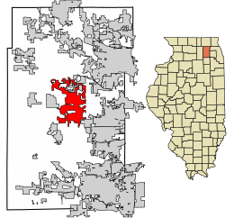
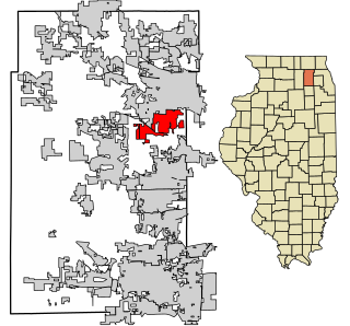
Kane County is a county in the U.S. state of Illinois. According to the 2020 census, it has a population of 516,522, making it the fifth-most populous county in Illinois. Its county seat is Geneva, and its largest city is Aurora. Kane County is one of the collar counties of the metropolitan statistical area designated "Chicago–Naperville–Elgin, IL–IN–WI" by the US census.

<span class="mw-page-title-main">Hamilton County, Illinois</span> County in Illinois, United States

Hamilton County is a county located in the U.S. state of Illinois. At the 2020 census, its population was 7,993. Its county seat is McLeansboro. It is located in the southern portion of the state known locally as "Little Egypt".

<span class="mw-page-title-main">Greene County, Illinois</span> County in Illinois, United States

Greene County is a county located in the U.S. state of Illinois. According to the 2020 United States Census, it has a population of 11,843. Its county seat is Carrollton.

<span class="mw-page-title-main">Carroll County, Illinois</span> County in Illinois, United States

Carroll County is a county located in the U.S. state of Illinois. As of the 2020 census, the population was 15,702. Its county seat is Mount Carroll.

<span class="mw-page-title-main">Barrington Hills, Illinois</span> Village in Illinois, United States

Barrington Hills is a village located about 40 miles (64 km) northwest of Chicago in the U.S. state of Illinois. Per the 2020 census, the population was 4,114. It straddles approximately 29 square miles (75 km2) over four counties, Cook, Kane, Lake, and McHenry. The Village of Barrington Hills was incorporated in 1957.

<span class="mw-page-title-main">Bartlett, Illinois</span> Village in Illinois, United States

Bartlett is a village located in Cook, DuPage and Kane counties, Illinois. A small parcel on the western border is in Kane County. The population was 41,105 at the 2020 census.

<span class="mw-page-title-main">Streamwood, Illinois</span> Village in Illinois, United States

Streamwood is a village in Cook County, Illinois, United States. Per the 2020 census, the population was 39,577. It is a northwest suburb of Chicago, and is a part of the Chicago metropolitan area.

<span class="mw-page-title-main">Freeman Spur, Illinois</span> Village in Illinois, United States

Freeman Spur is a village in Williamson and Franklin Counties, Illinois, United States. The population was 287 at the 2010 census.

<span class="mw-page-title-main">Carpentersville, Illinois</span> Village in Illinois, United States

Carpentersville is a village in Kane County, Illinois, United States. The population was 37,983 at the 2020 census.

<span class="mw-page-title-main">Elburn, Illinois</span> Village in Illinois, United States

Elburn is a village in Kane County, Illinois, United States. The population was 5,602 as of the 2010 census, up from 2,756 at the 2000 census. It is located at the intersection of Illinois Route 38 and Route 47. Elburn is a town situated 46 miles (74 km) west of the Chicago Loop with frequent commuter rail service from its Metra station at the end of the Union Pacific West Line.

<span class="mw-page-title-main">Huntley, Illinois</span> Village in Illinois, United States

Huntley is a village in McHenry and Kane counties, Illinois, United States. As of the 2021 census it had a population of 28,008. It is a part of the Chicago metropolitan area.

<span class="mw-page-title-main">Lily Lake, Illinois</span> Village in Illinois, United States

Lily Lake is a small rural village in Kane County, Illinois, United States. The town is 15 miles (24 km) southwest of Elgin and 50 miles (80 km) west of Chicago. The village is in the far western part the Chicago metro area. It was incorporated as a village on November 6, 1990. The population was 1,032 at the 2020 census, up from 993 in 2010.

<span class="mw-page-title-main">South Elgin, Illinois</span> Village in Illinois, United States

South Elgin is a village in Kane County, Illinois, United States. Per the 2020 census, the population was 23,865. In 2007, Money magazine named South Elgin as 82nd of 100 entries in its "America's Best Places to Live" edition and again in 2011 as 98th of 100 entries.

<span class="mw-page-title-main">West Dundee, Illinois</span> Village in Illinois, United States

West Dundee is a village in Kane County, Illinois, United States. The population was 7,686 as of the 2020 US Census. It is considered a far northwest Chicago suburb.

<span class="mw-page-title-main">Bull Valley, Illinois</span> Village in Illinois, United States

Bull Valley is a village in McHenry County, Illinois, United States. The population was 1,128 at the 2020 census. Surrounded by the suburban sprawl of Crystal Lake, Woodstock, and McHenry, the village prides itself in its rural, low-density character.

<span class="mw-page-title-main">Campton Township, Kane County, Illinois</span> Township in Illinois, United States

Campton Township is located in Kane County, Illinois. As of the 2010 census, its population was 17,174 and it contained 5,662 housing units.

References

  1. 1 2 3 U.S. Geological Survey Geographic Names Information System: Campton Hills, Illinois
  2. "2020 U.S. Gazetteer Files". United States Census Bureau. Archived from the original on March 15, 2022. Retrieved March 15, 2022.
  3. "U.S. Census website". United States Census Bureau. Archived from the original on July 9, 2021. Retrieved November 16, 2011.
  4. Presecky, William (May 15, 2007). "Kane County's newest village is born". Chicago Tribune . Archived from the original on August 28, 2016. Retrieved August 26, 2016.
  5. The Chicago Tribune reports 222 square miles (570 km2), which would constitute over 40% of the county's area. Supporters' own profile says 20.3 square miles (53 km2).
  6. Illinois Compiled Statutes, 65 ILCS 5/7‑3‑1
  7. CF Geographics LLC, official village map
  8. Menchaca, Charles (January 29, 2015). "Judge orders primary election in Campton Hills". Kane County Chronicle .
  9. Schory, Brenda (April 7, 2015). "'A new day' in Campton Hills". Kane County Chronicle .
  10. "G001 - Geographic Identifiers - 2010 Census Summary File 1". United States Census Bureau. Archived from the original on February 13, 2020. Retrieved August 2, 2015.
  11. "Census of Population and Housing". Census.gov. Archived from the original on April 26, 2015. Retrieved June 4, 2015.
  12. "Campton Hills 2010 Census Data". United States Census Bureau . US Census Bureau. Archived from the original on July 9, 2021. Retrieved January 16, 2014.
  13. "Village of Campton Hills Comprehensive Plan" (PDF). Village of Campton Hills. July 2012. Archived from the original on October 19, 2016. Retrieved May 18, 2017.
  14. "Campton Township Open Space Map" (PDF). Village of Campton Hills. March 2013. Archived from the original (PDF) on February 2, 2014. Retrieved May 18, 2017.