
Mid Bedfordshire was, from 1974 to 2009, a local government district in Bedfordshire, England.

Potton is a town and civil parish in the Central Bedfordshire district of Bedfordshire, England, about 10 miles (16 km) east of the county town Bedford. The parish had a population in 2021 of 5,727. In 1783 the Great Fire of Potton destroyed a large part of the town. The parish church dates from the 13th century, and is dedicated to St Mary. Potton's horse fairs were some of the largest in the country.

Campton is a village and former civil parish, now in the parish of Campton and Chicksands, in the Central Bedfordshire district of Bedfordshire, England. It is about 9 miles (14 km) south of Bedford, and is about 9 miles (14 km) north-west from Letchworth and sits on a tributary of the River Ivel. It is just to the west of Shefford. The 13th century Church of All Saints is in the centre of the village. In 1961 the parish had a population of 358.

A civil parish is a country subdivision, forming the lowest unit of local government in England. There are 125 civil parishes in the ceremonial county of Bedfordshire, most of the county being parished: Luton is completely unparished; Central Bedfordshire is entirely parished. At the 2001 census, there were 312,301 people living in the 125 parishes, which accounted for 55.2 per cent of the county's population.
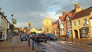
Shefford is a town and civil parish in the Central Bedfordshire district of Bedfordshire, England. At the 2021 census it had a population of 7,311. It lies 10 miles (16 km) south-east of Bedford. The town gives its name to Shefford, Quebec.

Chicksands is a village and former civil parish, now in the parish of Campton and Chicksands in the Central Bedfordshire district of Bedfordshire, England. The village is on the River Flit and close to its parish village of Campton and the town of Shefford.
Aspley Heath is a village and civil parish in the Central Bedfordshire district of Bedfordshire, England, elevated and small in population and area, mostly covered by New Wavendon Heath and a smaller mixed eponymous woodland. It was until some time after 1912 part of Aspley Guise. The Office for National Statistics records the village as part of the Woburn Sands urban subdivision of the Milton Keynes urban area. In addition to the village of Aspley Heath itself, the civil parish also includes part of the town of Woburn Sands, the rest of which is in the City of Milton Keynes in Buckinghamshire.
Brogborough is a village and civil parish in the Central Bedfordshire district of Bedfordshire, England, by junction 13 of the M1 motorway. According to the 2001, census it had a population of 343, reducing to 302 at the 2011 Census. The village is about 2.5 miles (4 km) east of Milton Keynes in Buckinghamshire.
Biggleswade was a rural district in Bedfordshire, England from 1894 to 1974. As initially created the district entirely surrounded but did not include Biggleswade, which was an urban district in its own right. In 1927 the parish of Sandy, which bordered Biggleswade, also became an urban district, leaving an island of two urban districts surrounded by the rural district.
Beadlow is a hamlet in the Central Bedfordshire district of Bedfordshire, England. At the 2011 Census the population of the hamlet was included in the civil parish of Campton and Chicksands.

Clifton is a village and civil parish in the English county of Bedfordshire. The original hundred of Clifton is named after it.

Cople is a village and civil parish in the English county of Bedfordshire. The name Cople is derived from the phrase Cock Pool, a place where chickens were kept, that was mentioned in the Domesday Book.

Meppershall is a hilltop village in Bedfordshire near Shefford, Campton, Shillington, Stondon and surrounded by farmland. The village and the manor house are mentioned in the Domesday Book in 1086 - with the entry reading: Malpertesselle/Maperteshale: Gilbert FitzSolomon.
Ministry of Defence Chicksands, or more simply MOD Chicksands, is a tri-service British Armed Forces facility in Bedfordshire, approximately 35 miles (56 km) north of London. The site was formerly the home of the Defence Intelligence and Security Centre (DISC) after it moved from Ashford in 1997. The Joint Intelligence Training Group (JITG) is based at MOD Chicksands.

Central Bedfordshire is a unitary authority area in the ceremonial county of Bedfordshire, England. It was created in 2009.

Gravenhurst is a civil parish located in the Central Bedfordshire district of Bedfordshire, England.

Stondon is a civil parish located in the Central Bedfordshire district of Bedfordshire, England. The parish includes the settlements of Lower Stondon and Upper Stondon.

Sir Stanley John Odell was a British businessman who was Chairman of the National Union of Conservative and Unionist Associations from 1989 to 1990, an organisation of the Conservative Party in the United Kingdom.
The Church of All Saints is the Anglican parish church in the village of Campton, Shefford, Bedfordshire, England. Its official title is Campton and Chicksands Parish and encompasses the villages of Campton and Chicksands and the nearby military base, despite the base having its own church dedicated to Saint Gilbert of Sempringham. The military church is a non-denominational church, so it is not a part of the Anglican parish.
