
The ionosphere is the ionized part of the upper atmosphere of Earth, from about 48 km (30 mi) to 965 km (600 mi) above sea level, a region that includes the thermosphere and parts of the mesosphere and exosphere. The ionosphere is ionized by solar radiation. It plays an important role in atmospheric electricity and forms the inner edge of the magnetosphere. It has practical importance because, among other functions, it influences radio propagation to distant places on Earth. It also affects GPS signals that travel through this layer.
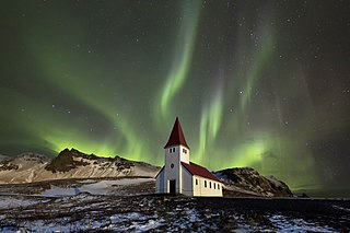
An aurora , also commonly known as the northern lights or southern lights, is a natural light display in Earth's sky, predominantly seen in high-latitude regions. Auroras display dynamic patterns of brilliant lights that appear as curtains, rays, spirals, or dynamic flickers covering the entire sky.

A geomagnetic storm, also known as a magnetic storm, is a temporary disturbance of the Earth's magnetosphere caused by a solar wind shock wave.

IMAGE was a NASA Medium Explorer mission that studied the global response of the Earth's magnetosphere to changes in the solar wind. It was believed lost but as of August 2018 might be recoverable. It was launched 25 March 2000, at 20:34:43.929 UTC, by a Delta II launch vehicle from Vandenberg Air Force Base on a two-year mission. Almost six years later, it unexpectedly ceased operations in December 2005 during its extended mission and was declared lost. The spacecraft was part of NASA's Sun-Earth Connections Program, and its data has been used in over 400 research articles published in peer-reviewed journals. It had special cameras that provided various breakthroughs in understanding the dynamics of plasma around the Earth. The principal investigator was Jim Burch of the Southwest Research Institute.

Cluster II was a space mission of the European Space Agency, with NASA participation, to study the Earth's magnetosphere over the course of nearly two solar cycles. The mission was composed of four identical spacecraft flying in a tetrahedral formation. As a replacement for the original Cluster spacecraft which were lost in a launch failure in 1996, the four Cluster II spacecraft were successfully launched in pairs in July and August 2000 onboard two Soyuz-Fregat rockets from Baikonur, Kazakhstan. In February 2011, Cluster II celebrated 10 years of successful scientific operations in space. In February 2021, Cluster II celebrated 20 years of successful scientific operations in space. As of March 2023, its mission was extended until September 2024. The China National Space Administration/ESA Double Star mission operated alongside Cluster II from 2004 to 2007.

A Birkeland current is a set of electrical currents that flow along geomagnetic field lines connecting the Earth's magnetosphere to the Earth's high latitude ionosphere. In the Earth's magnetosphere, the currents are driven by the solar wind and interplanetary magnetic field and by bulk motions of plasma through the magnetosphere. The strength of the Birkeland currents changes with activity in the magnetosphere. Small scale variations in the upward current sheets accelerate magnetospheric electrons which, when they reach the upper atmosphere, create the Auroras Borealis and Australis.

Ørsted is an Earth science satellite launched in 1999 to study the Earth's geomagnetic field. It is Denmark's first satellite, named after Hans Christian Ørsted (1777–1851), a Danish physicist and professor at the University of Copenhagen, who discovered electromagnetism in 1820.
The following is a chronology of discoveries concerning the magnetosphere.

The Super Dual Auroral Radar Network (SuperDARN) is an international scientific radar network consisting of 35 high frequency (HF) radars located in both the Northern and Southern Hemispheres. SuperDARN radars are primarily used to map high-latitude plasma convection in the F region of the ionosphere, but the radars are also used to study a wider range of geospace phenomena including field aligned currents, magnetic reconnection, geomagnetic storms and substorms, magnetospheric MHD waves, mesospheric winds via meteor ionization trails, and interhemispheric plasma convection asymmetries. The SuperDARN collaboration is composed of radars operated by JHU/APL, Virginia Tech, Dartmouth College, the Geophysical Institute at the University of Alaska Fairbanks, the Institute of Space and Atmospheric Studies at the University of Saskatchewan, the University of Leicester, Lancaster University, La Trobe University, the Solar-Terrestrial Environment Laboratory at Nagoya University, the British Antarctic Survey and the Institute for Space Astrophysics and Planetology.

The plasmasphere, or inner magnetosphere, is a region of the Earth's magnetosphere consisting of low-energy (cool) plasma. It is located above the ionosphere. The outer boundary of the plasmasphere is known as the plasmapause, which is defined by an order of magnitude drop in plasma density. In 1963 American scientist Don Carpenter and Soviet astronomer Konstantin Gringauz proved the plasmasphere and plasmapause's existence from the analysis of very low frequency (VLF) whistler wave data. Traditionally, the plasmasphere has been regarded as a well behaved cold plasma with particle motion dominated entirely by the geomagnetic field and, hence, co-rotating with the Earth.

Time History of Events and Macroscale Interactions during Substorms (THEMIS) mission began in February 2007 as a constellation of five NASA satellites to study energy releases from Earth's magnetosphere known as substorms, magnetic phenomena that intensify auroras near Earth's poles. The name of the mission is an acronym alluding to the Titan Themis.

The magnetosphere of Jupiter is the cavity created in the solar wind by Jupiter's magnetic field. Extending up to seven million kilometers in the Sun's direction and almost to the orbit of Saturn in the opposite direction, Jupiter's magnetosphere is the largest and most powerful of any planetary magnetosphere in the Solar System, and by volume the largest known continuous structure in the Solar System after the heliosphere. Wider and flatter than the Earth's magnetosphere, Jupiter's is stronger by an order of magnitude, while its magnetic moment is roughly 18,000 times larger. The existence of Jupiter's magnetic field was first inferred from observations of radio emissions at the end of the 1950s and was directly observed by the Pioneer 10 spacecraft in 1973.

The Global Geospace Science (GGS) Polar satellite was a NASA science spacecraft designed to study the polar magnetosphere and aurorae. It was launched into orbit in February 1996, and continued operations until the program was terminated in April 2008. The spacecraft remains in orbit, though it is now inactive. Polar is the sister ship to GGS Wind.
Dynamics Explorer was a NASA mission, launched on 3 August 1981, and terminated on 28 February 1991. It consisted of two unmanned satellites, DE-1 and DE-2, whose purpose was to investigate the interactions between plasmas in the magnetosphere and those in the ionosphere. The two satellites were launched together into polar coplanar orbits, which allowed them to simultaneously observe the upper and lower parts of the atmosphere.

The Injun program was a series of six satellites designed and built by researchers at the University of Iowa to observe various radiation and magnetic phenomena in the ionosphere and beyond.

A substorm, sometimes referred to as a magnetospheric substorm or an auroral substorm, is a brief disturbance in the Earth's magnetosphere that causes energy to be released from the "tail" of the magnetosphere and injected into the high latitude ionosphere. Visually, a substorm is seen as a sudden brightening and increased movement of auroral arcs. Substorms were first described in qualitative terms by Kristian Birkeland which he called polar elementary storms. Sydney Chapman used the term substorm about 1960 which is now the standard term. The morphology of aurora during a substorm was first described by Syun-Ichi Akasofu in 1964 using data collected during the International Geophysical Year.
The impact of the solar wind onto the magnetosphere generates an electric field within the inner magnetosphere - the convection field. Its general direction is from dawn to dusk. The co-rotating thermal plasma within the inner magnetosphere drifts orthogonal to that field and to the geomagnetic field Bo. The generation process is not yet completely understood. One possibility is viscous interaction between solar wind and the boundary layer of the magnetosphere (magnetopause). Another process may be magnetic reconnection. Finally, a hydromagnetic dynamo process in the polar regions of the inner magnetosphere may be possible. Direct measurements via satellites have given a fairly good picture of the structure of that field. A number of models of that field exists.

STEVE is an atmospheric optical phenomenon that appears as a purple and green light ribbon in the night sky, named in late 2016 by aurora watchers from Alberta, Canada. According to analysis of satellite data from the European Space Agency's Swarm mission, the phenomenon is caused by a 25 km (16 mi) wide ribbon of hot plasma at an altitude of 450 km (280 mi), with a temperature of 3,000 °C and flowing at a speed of 6 km/s (3.7 mi/s). The phenomenon is not rare, but had not been investigated and described scientifically prior to that time.

Dynamics Explorer 1 was a NASA high-altitude mission, launched on 3 August 1981, and terminated on 28 February 1991. It consisted of two satellites, DE-1 and DE-2, whose purpose was to investigate the interactions between plasmas in the magnetosphere and those in the ionosphere. The two satellites were launched together into polar coplanar orbits, which allowed them to simultaneously observe the upper and lower parts of the atmosphere.
Dynamics Explorer 2 was a NASA low-altitude mission, launched on 3 August 1981. It consisted of two satellites, DE-1 and DE-2, whose purpose was to investigate the interactions between plasmas in the magnetosphere and those in the ionosphere. The two satellites were launched together into polar coplanar orbits, which allowed them to simultaneously observe the upper and lower parts of the atmosphere.


