
Marche, in English sometimes referred to as the Marches, is one of the twenty regions of Italy. The region is located in the central area of the country, and has a population of about 1.5 million people, being the thirteenth largest region in the country by number of inhabitants. The region's capital and largest city is Ancona.

The Savio is a river in the Emilia-Romagna region of northern Italy. Its source is in the province of Forlì-Cesena near Montecoronaro on Mount Castelvecchio which is near the western side of Mount Fumaiolo. The source is at an elevation of 1,126 metres (3,694 ft) and is marked by an iron monument. A wolf and the rings of the caveja are on this monument. The river flows near Verghereto and Bagno di Romagna as it winds through the mountains before entering Lago di Quarto. After leaving the lake, the river flows northeast near Sarsina and Mercato Saraceno before flowing north. The river winds for 96 kilometres (60 mi) along the valley. Its natural track has been preserved relatively well and, in the territory of Cesena, it shows an environment which is one of the purest of the whole Romagna. North of Cesena, the river crosses the border into the province of Ravenna. After a total course of 126 kilometres (78 mi) the river enters the Adriatic Sea north of Cervia by Lido di Classe and Lido di Savio.

The Metauro is a river in the Marche region of central Italy. It rises in the Apennine Mountains and runs east for 110 kilometres (68 mi) or 121 kilometres (75 mi) if the Meta is included as its uppermost reach.
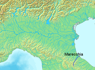
The Marecchia is a river in eastern Italy, flowing from near Monte dei Frati in the province of Arezzo, Tuscany, to the Adriatic Sea in Rimini, Emilia-Romagna. Along its course, the river passes next to or near the settlements of Novafeltria, Verucchio, and Santarcangelo di Romagna. It passes near the Republic of San Marino. Among its tributaries are the San Marino river and the Ausa.

Carpegna is a comune (municipality) in the Province of Pesaro e Urbino in the Italian region Marche, located about 100 kilometres (62 mi) west of Ancona and about 50 kilometres (31 mi) southwest of Pesaro.

Fermignano is a comune (municipality) in the Province of Pesaro e Urbino in the Italian region Marche, located about 70 kilometres (43 mi) west of Ancona and about 35 kilometres (22 mi) southwest of Pesaro.

Orciano di Pesaro is a frazione of the comune of Terre Roveresche in the Province of Pesaro e Urbino in the Italian region Marche, located about 45 kilometres (28 mi) west of Ancona and about 25 kilometres (16 mi) south of Pesaro. It is located on a hill dividing the valleys of the Metauro and Cesano rivers. It was a separate comune until 2017.

Piandimeleto is a comune (municipality) in the Province of Pesaro e Urbino in the Italian region Marche, located about 90 kilometres (56 mi) west of Ancona and about 45 kilometres (28 mi) southwest of Pesaro.

Sant'Angelo in Vado is a comune (municipality) in the province of Pesaro and Urbino, in the Italian region of Marche.

Urbania is a comune (municipality) in the Province of Pesaro e Urbino in the Italian region of Marche, located about 80 kilometres (50 mi) west of Ancona and about 40 kilometres (25 mi) southwest of Pesaro, next to the river Metauro.

The Cesano is a river in the Marche region of Italy. Its source is near Monte Catria on the border between the province of Perugia and the province of Pesaro e Urbino. The river flows northeast through Pesaro e Urbino before forming the border between Pesaro e Urbino and the province of Ancona for a short distance. It continues flowing northeast through Pesaro e Urbino and flows past Pergola before becoming the border with Ancona again near San Lorenzo in Campo. The river flows northeast near Mondavio, Corinaldo and Monte Porzio before the province of Ancona extends westward beyond the bank of the river for a short distance near Mondolfo. Finally, the river flows into the Adriatic Sea north of Senigallia and south of Marotta and Fano.

The Foglia is the northernmost river of the Marche region of Italy. In ancient times it was known as Pisaurus, as it debouched into the Adriatic Sea at Pisaurum. It was also known as the Isaurus. The source of the river is west of Sestino in the province of Arezzo in the Umbrian-Marchean Apennines mountains. It flows east through an extension of the province of Pesaro e Urbino and then back into Arezzo before forming the border between Arezzo and Pesaro e Urbino. The river then flows into the province of Pesaro e Urbino past Piandimeleto and curves northeast and flows past Sassocorvaro before curving east again. The river meanders south of Montecalvo in Foglia before curving northeast and flowing near Colbordolo, Saludecio, Sant'Angelo in Lizzola, Montecchio, Montelabbate and Tavullia before entering the Adriatic Sea near Pesaro.

The Conca is a river in the Marche and Emilia-Romagna regions of Italy. Its source is Monte Carpegna, which is in the Montefeltro part of the province of Pesaro e Urbino. The river flows northeast near Macerata Feltria and Mercatino Conca before crossing into the province of Rimini. The river then flows past Morciano di Romagna before entering the Adriatic Sea southeast of Misano Adriatico and northwest of Cattolica.

Bianchello del Metauro is a denominazione di origine controllata wine made in the province of Pesaro and Urbino, in the region of Marche, Italy. The DOC was created in 1969.
Monte dei Frati is a mountain in the Italian province of Arezzo near the border with Pesaro e Urbino and Perugia.
The Biscubio is a river in the Umbria and Marche regions of Italy. Its source is in the province of Perugia near the border with the province of Pesaro e Urbino in the Appennino Umbro-Marchigiano mountains. The river flows northeast into Pesaro e Urbino south of Mercatello sul Metauro. It then flows east through the mountains near Apecchio and the exclave called Monte Ruperto belonging to Città di Castello until it joins the Candigliano near Piobbico.

The Burano is a river in the Umbria and Marche regions of Italy. Its source is in the province of Perugia in the Appennino Umbro-Marchigiano mountains. The river crosses the border into the province of Pesaro e Urbino and flows north near Monte Catria, Cantiano, Monte Nerone, and Cagli before entering the Candigliano at Acqualagna.

The Ponte della Concordia is a bridge over the river Metauro in Fossombrone, Province of Pesaro and Urbino, region of Marche, Italy.

Colli all Metauro is a comune (municipality) in the Province of Pesaro e Urbino in the Italian region Marche. It was created on 1 January 2017 after the merger of the comuni of Montemaggiore al Metauro, Saltara and Serrungarina. The communal seat is at Calcinelli, its largest frazione.
Sorbolongo is a town consisting of about 460 inhabitants in the municipality of Sant'Ippolito in the province of Pesaro and Urbino, Italy. It is almost completely made up of a castle that still maintains its original medieval structure. Sorbolongo castle is located on the hills between the Metauro and Cesano river valleys, located on the road that connects the capital Sant'Ippolito to the neighboring municipality of Barchi.

