Cann Quarry Canal

Last updated

Cann Quarry Canal
Cann Quarry Canal - geograph.org.uk - 122612.jpg
Much of the canal is still visible
Specifications
Statusabandoned
History
Date of actPrivately built
Date of first use1829
Date closed1839
Geography
Start pointCann Quarry
End pointMarsh Mills
Cann Quarry Canal
BSicon exCONTg.svg
Railway to Tavistock
BSicon uexSTR+l.svg
BSicon uexSTRq.svg
BSicon uexSTRq.svg
BSicon uexSTRq.svg
BSicon exmKRZo.svg
BSicon uexCONTfq.svg
River Plym
BSicon uexSTR.svg
BSicon exSTR.svg
BSicon exSTR.svg
Earl Morley's Tramway
BSicon uexSTR.svg
BSicon exSTR.svg
BSicon uexWHRF.svg
BSicon exSTR.svg
Cann Quarry Wharf
BSicon uexSTR.svg
BSicon exSTR.svg
BSicon uexSTR.svg
BSicon exSTR.svg
BSicon uexSTR.svg
BSicon exSTR+l.svg
BSicon exKRZu.svg
BSicon uexmKRZu.svg
BSicon exSTRr.svg
Railway Bridge
BSicon uexSTR.svg
BSicon exSTR.svg
BSicon exABZg+l.svg
BSicon uexmKRZu.svg
BSicon exSTRq.svg
BSicon exCONTfq.svg
Lee Moor incline
BSicon uexSTR.svg
BSicon BHF.svg
BSicon exSTR.svg
BSicon uexSTRl.svg
BSicon uexSTR+r.svg
Plymbridge Halt
BSicon uexSTR.svg
BSicon STRl.svg
BSicon xKRZ.svg
BSicon STR+r.svg
BSicon uexSTR.svg
Lee Moor Crossing
BSicon uexSTR.svg
BSicon exSTR.svg
BSicon STR.svg
BSicon uexSTR.svg
BSicon uexSTR.svg
BSicon exSTR+l.svg
BSicon exSTRr.svg
BSicon STR.svg
BSicon uexSTR.svg
BSicon uexSTR.svg
BSicon exSTR.svg
BSicon uexSTR+l.svg
BSicon emKRZo.svg
BSicon uexSTRr.svg
Rebuilt bridge 3
BSicon uexSTR.svg
BSicon exSTR.svg
BSicon uexSTRl.svg
BSicon emKRZo.svg
BSicon uexSTRq.svg
BSicon uexSTR+r.svg
Rebuilt bridge 2
BSicon uexSTR.svg
BSicon exSTRl.svg
BSicon exSTR+r.svg
BSicon STR.svg
BSicon uexSTR.svg
BSicon uexSTR.svg
BSicon exSTR.svg
BSicon STR.svg
BSicon STR+l.svg
BSicon uxmKRZu.svg
To China Clay Works
BSicon uexSTR.svg
BSicon exSTR.svg
BSicon BHF.svg
BSicon STR.svg
BSicon uexSTR.svg
Marsh Mills Stn
BSicon uexSTRl.svg
BSicon uexSTR+r.svg
BSicon exSTR.svg
BSicon xABZg+l.svg
BSicon STRr.svg
BSicon uexWHRF.svg
Marsh Mills Wharf
BSicon exSTR+l.svg
BSicon uexmKRZu.svg
BSicon exABZqr.svg
BSicon eKRZ.svg
BSicon exSTRq.svg
BSicon exSTRq.svg
1829 Branch
BSicon exSTR.svg
BSicon uexABZg+l.svg
BSicon uexSTRq.svg
BSicon emKRZo.svg
BSicon uexSTRq.svg
BSicon uexCONTfq.svg
Tory Brook
BSicon exSTR.svg
BSicon uexSTR.svg
BSicon xABZgl+l.svg
BSicon STRq.svg
BSicon CONTfq.svg
Exeter to Plymouth line
BSicon exSTR.svg
BSicon uexSTRl.svg
BSicon uexSTRq.svg
BSicon emKRZo.svg
BSicon uexSTRq.svg
BSicon uexCONTfq.svg
River Plym
BSicon exABZql.svg
BSicon exSTR+r.svg
BSicon CONTf.svg
Crabtree Junction, P&DR

The Cann Quarry canal was a canal in Devon, England which ran for just under 2 miles (3.2 km) from Cann Quarry to the River Plym at Marsh Mills. It opened in 1829, and a short tramway connected it to the Plymouth and Dartmoor Railway at Crabtree Junction. It had been replaced by a tramway within ten years, but continued to be used as a mill leat to supply Marsh Mills corn mill, and most of it is still visible.

Contents

History

In 1778, the Cann Slate Quarry was owned by John Parker, and in order to make transport of the slate easier, he asked the engineer John Smeaton to survey a canal, to run from the quarry to the bridge at Marsh Mills. The River Plym between the bridge and Plymouth was navigable by barges. Although Smeaton carried out the work, he concluded that the canal, which would be 2.25 miles (3.62 km) long and would need several locks to accommodate the drop of 30 feet (9.1 m) in level, was unlikely to be economic, since the only trade would be the output from the quarry. He therefore suggested that a tramway would be a better solution, and could be built for about half the cost of the canal. Parker did not proceed with either option. [1]

In 1819, an Act of Parliament was obtained which authorised the construction of a horse tramway between Princetown and Plymouth. In 1821, the directors of the Plymouth and Dartmoor horse tramway applied for a second Act, to authorise a deviation to the route, and in order to obtain consent for the new route from Parker's son, also called John Parker and Earl of Morley since 1815, they agreed to build a branch, possibly including an inclined plane, to the quarry. The company ran into financial difficulties, and the branch was not built. Despite the fact that he was a member of the management committee for the tramway, Parker took legal action against the three directors who had proposed the branch. They suggested that he should build the branch himself, and in return, all goods transferring from it to the existing tramway would be subject to lower tolls. [2]

Parker proceeded to build a tub-boat canal from the quarry to Marsh Mills. It was about 6 feet (1.8 m) wide, and stopped above the bridge. He then wrote to the tramway company, suggesting that he was undecided whether to complete the canal by tunnelling under the turnpike road to connect it to the river, or to link it to their tramway at Crabtree by building a private branch. The letter resulted in an agreement on tolls, and the private tramway was built to complete the link. The canal was a little under 2 miles (3.2 km) long, and the tramway was about 0.5 miles (0.80 km) long. It crossed the river on a cast iron bridge with two arches. [3]

The canal was opened on 20 November 1829. Some time after 1834 [4] and before 1839, Earl Morley's tramway was extended up the valley to Cann Quarry. Near the quarry, it was built on the canal bank, but lower down it was built further to the west. Once it was opened, the canal ceased to be used as a navigation and served as a mill leat for the corn mill at Marsh Mills. A branch of the tramway, which was built to the unusual gauge of 4 ft 6 in (1,372 mm), was constructed from Plym Bridge to the quarries at Lee Moor, and the whole railway became known as the Lee Moor Tramway. The South Devon and Tavistock Railway built a branch up the Plym Valley, which was completed in 1854. For most of its route between Marsh Mills and the quarry, it was built between Earl Morley's tramway and the canal. The new railway cut across the quarry, which closed the following year. [5] [6] Marsh Mills corn mill continued to operate until 1927, when the owners became bankrupt. [7]

Route

The towpath of the disused Cann Quarry Canal, Plymbridge, after rain Cann Quarry Canal towpath after rain - Plymbridge.jpg
The towpath of the disused Cann Quarry Canal, Plymbridge, after rain

Crabtree Junction, where Earl Morley's Tramway joined the Plymouth and Dartmouth Railway, has disappeared, covered by a motel and the interchange between the A38 road and the A374 road, although the two-arched cast iron bridge over the River Plym remains. The tramway towards the quarry has become a cycleway and long-distance footpath, known as the West Devon Way, while most of the canal is still visible, and is often filled with water after rainfall, although the final section at Marsh Mills is not visible. The South Devon and Tavistock Railway branch was abandoned, but the lower end is now part of the Plym Valley Railway. The current Marsh Mills Station is a little further to the north than the original one, as a mineral line which serves a china clay works still passes through the old site. The Plym Valley Railway is being extended to Plym Bridge, where the Lee Moor incline branched off. The railway crosses the route of the canal in two places on this section, and both of the bridges have been rebuilt as part of the restoration. [8] Beyond Plym Bridge, the cycleway leaves Earl Morley's tramway and follows the South Devon and Tavistock Railway instead, allowing it to cross the River Plym just beyond Cann Quarry, and continue on to Yelverton. [9]

Points of interest

Map all coordinates using: OpenStreetMap  
Download coordinates as: KML

See also

Bibliography

Related Research Articles

River Plym river in Devon, England

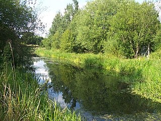
The River Plym is a river in Devon, England. It runs from Dartmoor in the centre of the county southwest to meet the River Meavy, then south towards Plymouth Sound. The river is popular with canoeists, and the Plym Valley Railway runs alongside a section of the river.

Plympton A suburb of Plymouth, England

Plympton now forms a suburb of the city of Plymouth in Devon, England but is in origin an ancient stannary town. It was an important trading centre for locally mined tin, and a seaport before the River Plym silted up and trade moved down river to Plymouth and was the seat of Plympton Priory the most significant local landholder for many centuries.

The Plym Valley Railway is a 1+12-mile (2.4 km) heritage railway based on part of the now-closed South Devon and Tavistock Railway, a branch line of the Great Western Railway in Devon, England.

South Devon and Tavistock Railway

The South Devon and Tavistock Railway linked Plymouth with Tavistock in Devon; it opened in 1859. It was extended by the Launceston and South Devon Railway to Launceston, in Cornwall in 1865. It was a broad gauge line but from 1876 also carried the standard gauge trains of the London and South Western Railway between Lydford and Plymouth: a third rail was provided, making a mixed gauge. In 1892 the whole line was converted to standard gauge only.

Greasbrough Canal

The Greasbrough Canal was a private canal built by the Marquess of Rockingham to serve his coal mining interests in and around the village of Greasbrough, near Rotherham, South Yorkshire, England. It opened in 1780, and the Newbiggin branch was built some time later. The main line to Greasbrough closed in 1840 with the coming of the Sheffield and Rotherham Railway, and the canal ceased to carry commercial traffic during the First World War. Most of it has been filled in, but a small section near the River Don Navigation remains in water.

Haytor Granite Tramway Horse-drawn tramway built to convey granite (1820-1858)

The Haytor Granite Tramway was a tramway built to convey granite from Haytor Down, Dartmoor, Devon to the Stover Canal. It was very unusual in that the track was formed of granite sections, shaped to guide the wheels of horse-drawn wagons.

Treffry Viaduct

The Treffry Viaduct is a historic dual-purpose railway viaduct and aqueduct located close to the village of Luxulyan, Cornwall in the United Kingdom. The viaduct crosses the Luxulyan Valley, and with it forms an integral part of the Cornwall and West Devon Mining Landscape, a World Heritage Site. It is scheduled under the Ancient Monuments and Archaeological Areas Act 1979 and due to its poor condition is on Historic England's, Heritage at Risk Register.

Luxulyan Valley

The Luxulyan Valley is the steep sided and thickly wooded valley of the River Par, situated in mid Cornwall, England, UK. It contains a major concentration of early 19th century industrial remains, and was designated as part of a World Heritage Site in 2006.

Tavistock Canal

The Tavistock Canal is a canal in the county of Devon in England. It was constructed early in the 19th century to link the town of Tavistock to Morwellham Quay on the River Tamar, where cargo could be loaded into ships. The canal is still in use to supply water to a hydro-electric power plant at Morwellham Quay, and forms part of the Cornwall and West Devon Mining Landscape World Heritage Site. It is unusual for a canal, as it has a gentle slope over its length, resulting in a considerable flow of water.

Treffry Tramways

The Treffry Tramways were a group of mineral tramways in Cornwall in the United Kingdom, constructed by Joseph Treffry (1782-1850), a local land owner and entrepreneur. They were constructed to give transport facilities to several mines and pits producing non-ferrous metal, granite and china clay in the area between the Luxulyan Valley and Newquay, and were horse-operated, with the use of water and steam power on inclines, and at first operated in conjunction with the Par Canal and Par Docks, also constructed by Treffry. One of the routes crossed the Luxulyan Valley on a large viaduct, the largest in Cornwall when it was built.

Joseph Austen Treffry was an engineer, mining adventurer, and industrialist who became a significant landowner in Cornwall, England.

Exeter to Plymouth railway of the LSWR

The Exeter to Plymouth railway of the London and South Western Railway (LSWR) was the westernmost part of a route competing with that of the Great Western Railway (GWR) and its 'associated companies' from London and Exeter to Plymouth in Devon, England. Whereas the GWR route from Exeter followed the coast to Newton Abbot and then went around the southern edge of Dartmoor, the LSWR route followed the northern and western margins of Dartmoor, passing through the towns of Crediton, Okehampton, and Tavistock.

Pidcocks Canal

Pidcock's Canal was a canal in Gloucestershire, England, which connected ironworks at Upper Forge and Lower Forge, and also ran to an inlet from the River Severn called Lydney Pill. It was constructed from 1778 onwards, and there were three locks below Middle Forge. Following the construction of the Lydney Canal in 1813, the canal connected to that, rather than Lydney Pill, and it was disused after 1840, by which time a horse-drawn tramway had been built up the valley of The Lyd. The tramway was eventually relaid as a steam railway and is now preserved as the Dean Forest Railway. Most of the canal, colloquially called The Cut, still exists below Middle Forge.

Railways in Plymouth

The network of railways in Plymouth, Devon, England, was developed by companies affiliated to two competing railways, the Great Western Railway and the London and South Western Railway. At their height two main lines and three branch lines served 28 stations in the Plymouth area, but today just six stations remain in use.

Clearbrook Halt was a railway station on the South Devon and Tavistock Railway serving the villages of Clearbrook and Meavy in South Devon, nine miles to the North of Plymouth, and a mile and a half from Yelverton.

The Plymouth and Dartmoor Railway (P&DR) was a 4 ft 6 in gauge railway built to improve the economy of moorland areas around Princetown in Devon, England. Independent carriers operated horse-drawn wagons and paid the company a toll. It opened in 1823, and a number of short branches were built in the next few years.

Turnchapel Branch

The Turnchapel Branch was a London and South Western Railway (LSWR) single track branch railway line in Devon, England, that ran from Plymouth Friary station to Turnchapel. It crossed the River Plym and opened up the east side of the river to rail connections. The short line opened in 1892 and 1897 (throughout). It closed in 1951 to passengers, and in 1961 completely.

Princetown Railway

The Princetown Railway was a 10¼ mile single track branch railway line in Devon, England, that ran from Yelverton on the Plymouth to Tavistock line, to Princetown via four intermediate stations, Dousland, Burrator and Sheepstor Halt, Ingra Tor Halt and King Tor Halt. The line closed in 1956 and today forms part of a popular cycling and walking route.

Exeter–Plymouth line railway line in Devon, England

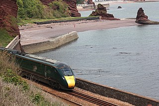
The Exeter–Plymouth line, also called the South Devon Main Line, is a central part of the trunk railway line between London Paddington and Penzance in the southern United Kingdom. It is a major branch of the Great Western Main Line and runs from Exeter to Plymouth, from where it continues as the Cornish Main Line. It was one of the principal routes of the Great Western Railway which in 1948 became part of the Western Region of British Railways and are now part of the Network Rail system.

Plymbridge Woods Woodland in Devon, England

Plymbridge Woods is a woodland in Plympton, Devon, England managed by The National Trust. The woods are named after the historic Plymbridge, a Grade II listed bridge over the River Plym. Drake's Trail passes through the woods providing a cycling and walking route. There is a range of wildlife, birds and flora.

References

  1. Hadfield 1985 , p. 122
  2. Hadfield 1985 , pp. 122–123
  3. Hadfield 1985 , p. 123
  4. Moseley, Brian (January 2011). "Cann Quarry Canal". The Encyclopaedia of Plymouth History. Plymouth Data. Archived from the original on 28 September 2013. Retrieved 14 February 2015.CS1 maint: discouraged parameter (link)
  5. Hadfield 1985 , pp. 123–124
  6. Ordnance Survey, 1:2500 and 1:10560 maps, 1907
  7. Moseley, Brian (August 2011). "Marsh Mill/Woodford Mill". The Encyclopaedia of Plymouth History. Plymouth Data. Archived from the original on 28 September 2013. Retrieved 14 February 2015.CS1 maint: discouraged parameter (link)
  8. "The Line Today". Plym Valley Railway. Archived from the original on 26 April 2012. Retrieved 19 December 2011.CS1 maint: discouraged parameter (link)
  9. Ordnance Survey, 1:25,000 map

Coordinates: 50°24′25″N4°04′59″W / 50.407°N 4.083°W / 50.407; -4.083