Maesbury Castle is an Iron Age hill fort within the parish of Croscombe on the Mendip Hills, just north of Shepton Mallet, Somerset, England. It has been listed as a Scheduled Ancient Monument.

Plainsfield Camp is a possible Iron Age earthwork on the Quantock Hills near Aisholt in Somerset, England.

Norton Camp is a Bronze Age hill fort at Norton Fitzwarren near Taunton in Somerset, England.

Bats Castle is an Iron Age hill fort at the top of a 213 metres (699 ft) high hill in the parish of Carhampton south south west of Dunster in Somerset, England.

Black Ball Camp is an Iron Age hill fort South West of Dunster, Somerset, England on the northern summit of Gallox Hill. It is a Scheduled Ancient Monument.
Blacker's Hill is an Iron Age hill fort at Chilcompton, 4.5 kilometres (3 mi) south west of Radstock, Somerset, England. It has been designated as a Scheduled Ancient Monument.

Clatworthy Camp is an Iron Age hill fort 3 miles (4.8 km) North West of Wiveliscombe, Somerset, England. It has been scheduled as an Ancient Monument. Due to the vulnerability to scrub and tree growth it has been added to the Heritage at Risk Register.

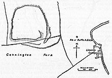
Kenwalch's Castle is probably an Iron Age hill fort that may have been converted into a Roman fortress, near Penselwood, Somerset, England, 6.6 kilometres (4 mi) east south east of Bruton at grid reference ST747335. It is a Scheduled Ancient Monument. It is believed to be named after Cenwalh of Wessex.
Kingsdown Camp is an Iron Age hill fort at Buckland Dinham 4.5 kilometres (3 mi) South East of Radstock, Somerset, England. It is a Scheduled Ancient Monument.
Eddisbury hill fort, also known as Castle Ditch, is an Iron Age hill fort near Delamere, Cheshire, in northern England. Hill forts are fortified hill-top settlements constructed across Britain during the Iron Age. Eddisbury is the largest and most complex of the seven hill forts in the county of Cheshire. It was constructed before 200–100 BC and expanded in 1–50 AD. In the 1st century AD, the Romans slighted the site. It was reoccupied in the 6th–8th centuries AD, and an Anglo-Saxon burh was probably established at Eddisbury in 914. In the medieval and post-medieval periods quarrying and farming have damaged the site. Ownership is currently split between the Forestry Commission and a local farm. Eddisbury is protected as a Scheduled Ancient Monument.

Tedbury Camp is a multivallate Iron Age promontory hill fort defended by two parallel banks near Great Elm, Somerset, England.

King's Castle is a Neolithic hillfort 1 kilometre (0.62 mi) east of Wiveliscombe in Somerset, England. It is surrounded by two banks with a ditch between them. The inner wall ranges up to 2.5 metres (8.2 ft) high and the outer wall gets up to 1.5 metres (4.9 ft) high. Arrowheads, scrapers, and borers have been found at the site. A coin hoard of 1139 coins was found in a pot buried 0.30 metres (1 ft) deep.

Ham Hill Hillfort is an Iron Age hillfort located on Ham Hill, Somerset, England. It was also occupied during the mesolithic and neolithic periods and later during Roman and medieval eras. The fort is a Scheduled Ancient Monument, and the whole of the hill is a geological Site of Special Scientific Interest, a country park operated by South Somerset Council, and is visited by over 250,000 people each year.
Curdon Camp is a univallate Iron Age hill fort in the West Somerset district of Somerset, England. It is a Scheduled Ancient Monument.
Westbury Camp is a univallate Iron Age hill fort in the Mendip Hills in Somerset, England. The hill fort is situated in the parish of Rodney Stoke, approximately 1 mile (1.6 km) north-east of the village of Draycott and 1.5 miles (2.4 km) north-west of Westbury-sub-Mendip. The camp is largely situated in a hill slope. The north east defences have largely been destroyed by small quarries over the years. The narrow top of the hill bank suggests that it may have been surmounted by a dry stone wall. Along part of the east side of the camp there are traces of a berm between the bank and the outer ditch and at the western angle shallow quarry pits occur internally and externally set back from the 'rampart'.
Tunley Camp is an vallate Iron Age hill fort situated approximately 0.8 miles (1.3 km) north-east from the small village of Camerton in the Bath and North East Somerset district of Somerset, England. The hill fort comprises the slight earthwork remains of a univallate Iron Age hillfort which now nearly ploughed down.
Berry Castle is an early Roman hillslope enclosure in the West Somerset district of Somerset, England. The hill fort is situated approximately 3.2 miles (5.1 km) west from the village of Luccombe. A series of earthworks survive in Berry Castle; it dates from the late Iron Age or early Romano British period. It has been protected as a scheduled monument.
Broomfield Camp is a univallate Iron Age hill fort in the Taunton Deane district of Somerset, England. The hill fort is situated approximately 0.6 miles (0.97 km) south-east from the village of Broomfield. Broomfield Camp dates from late prehistoric or Roman times. The camp was searched in 1968 and the result uncovered a trench through a bank and ditch which produced Iron Age pottery.
Castles Camp is a univallate Iron Age hill fort in the Taunton Deane district of Somerset, England. The hill fort is situated approximately 1 mile (1.6 km) west from the village of Bathealton. A few trees a scattered around the camp's defences along with Roman coins being found in previous years.
Creech Hill is a hill in south east Somerset, England, which is notable for a univallate Iron Age hill fort. The hill is situated approximately 1.2 miles (1.9 km) north west of the small town of Bruton.