Cannonsburg, Mississippi

Last updated
Cannonsburg, Mississippi
USA Mississippi location map.svg
Red pog.svg
Cannonsburg
Usa edcp location map.svg
Red pog.svg
Cannonsburg
Coordinates: 31°38′02″N91°12′40″W / 31.63389°N 91.21111°W / 31.63389; -91.21111 Coordinates: 31°38′02″N91°12′40″W / 31.63389°N 91.21111°W / 31.63389; -91.21111
Country United States
State Mississippi
County Jefferson
Elevation
276 ft (84 m)
Time zone UTC-6 (Central (CST))
  Summer (DST) UTC-5 (CDT)
GNIS feature ID690909 [1]

Cannonsburg (also Cannonsburgh) is an unincorporated community in Jefferson County, Mississippi, United States. [1]

It is located on U.S. Route 61, 11 mi (18 km) southwest of Fayette.

History

Shackleford Spring in Cannonsburg, where Andrew Jackson's weary troops camped and refreshed themselves while marching against the British during the War of 1812. Cannonsburg, Mississippi.jpg
Shackleford Spring in Cannonsburg, where Andrew Jackson's weary troops camped and refreshed themselves while marching against the British during the War of 1812.

Bethel Church was established in Cannonsburg in 1804, the first Presbyterian Church in the Mississippi Territory. A Mississippi historic plaque recognizing Joseph Bullen, the church's founder, is located east of the settlement. [3] [4]

The Bethlehem Baptist Church was organized in Cannonsburg in 1860, and served the community's freed blacks and ex-slaves. The Church held a prominent position in Jefferson County's social, religious, and civic life. During the 1960s, the church held the first civil rights mass meeting in Jefferson County. [5]

Cannonsburg was a stop on the Natchez, Jackson and Columbus Railroad, which began operating in the 1870s. [6]

By 1891, Cannonsburg had a post office and a population of 31. [7] The post office has since closed. [8]

An oil field known at the Cannonsburg Field is located north of the settlement. [9] [10]

Related Research Articles

<span class="mw-page-title-main">Washington, Mississippi</span> Unincorporated community in Mississippi, United States

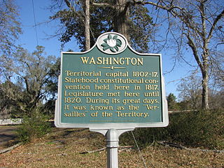
Washington is an unincorporated community in Adams County, Mississippi, United States. Located along the lower Mississippi, 6 miles (9.7 km) east of Natchez, it was the second and longest-serving capital of the Mississippi Territory.

Hermanville is a census-designated place and unincorporated community in Claiborne County, in southwest Mississippi, United States. Its ZIP code is 39086.

<span class="mw-page-title-main">Rodney, Mississippi</span> United States historic place

Rodney is a former city in Jefferson County in southwest Mississippi, approximately 32 miles (51 km) northeast of Natchez. Rodney was founded in 1828, and in the 19th century, it was only three votes away from becoming the capital of the Mississippi Territory. Its population declined to nearly zero after the Mississippi River changed course. The Rodney Center Historic District is listed on the National Register of Historic Places.

Carpenter is a small unincorporated community in Copiah County, Mississippi, United States. A former railroad town located seven miles from Utica in the extreme northwestern corner of the county, Carpenter was named for Joseph Neibert Carpenter, president of the Natchez, Jackson and Columbia Railroad.

<span class="mw-page-title-main">Lilly Chapel, Ohio</span> Unincorporated community in Ohio, United States

Lilly Chapel is an unincorporated community in Fairfield Township, Madison County, Ohio, United States. It is located at 39°53′20″N83°16′54″W, at the intersection of W. Jefferson Kiousville Road and Lilly Chapel Georgesville Road, approximately three miles west of Georgesville.

Tinsley is an unincorporated community located in Yazoo County, Mississippi, United States. Tinsley is approximately 11 miles (18 km) south of Yazoo City and 4 miles (6.4 km) North of Oil City near U.S. Route 49.

<span class="mw-page-title-main">Swiftown, Mississippi</span> Unincorporated community in Mississippi, United States

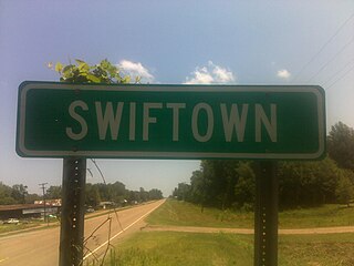
Swiftown, is an unincorporated community located in Leflore County, Mississippi, United States. Swiftown is approximately 7 miles (11 km) south of Morgan City, 10 miles (16 km) north of Belzoni and 14 miles (23 km) southeast of Moorhead along Mississippi Highway 7. It is part of the Greenwood, Mississippi micropolitan area. Swiftown's ZIP code is 38959.

Red Lick is an unincorporated community located in Jefferson County, Mississippi. Red Lick is approximately 5 miles (8.0 km) southeast of Lorman on Mississippi Highway 552.

Kirkville is a census-designated place and unincorporated community in Itawamba County, Mississippi, United States.

Jayess is an unincorporated community in Lawrence County, Mississippi, United States.

Sibley is an unincorporated community in Adams County, Mississippi, United States. There is a post office located on U.S. Route 61 in Sibley, ZIP code 39165.

Carlisle is an unincorporated community in Claiborne County, Mississippi, United States.

Duffee is an unincorporated community located in Newton County, Mississippi, United States. Duffee is approximately 6.3 miles (10.1 km) east-southeast of Little Rock south of Mississippi Highway 494.

Agency is a ghost town located in Oktibbeha County, Mississippi, United States.

Hutchins Landing is a ghost town in Adams County, Mississippi, United States.

Loch Leven is a ghost town in Wilkinson County, Mississippi, United States.

Rockport is an unincorporated community in Copiah County, Mississippi.

Danville is a ghost town in Alcorn County, Mississippi, United States.

<span class="mw-page-title-main">Old Greenville, Mississippi</span> Ghost town in Jefferson County, Mississippi

Old Greenville is a ghost town in Jefferson County, Mississippi, United States. The town was located along the old Natchez Trace and was once the largest town along the Trace. Nothing exists at the site today except the town's cemetery.

References

  1. 1 2 U.S. Geological Survey Geographic Names Information System: Cannonsburg
  2. "Works Progress Administration Scrapbooks". Mississippi Department of Archives and History. 1936–1941.
  3. Bates, George T. (November 12, 1967). "The Early Years of the Union Church Presbyterian Church". Old New Orleans.
  4. "Joseph Bullen". Stoppingpoints. June 17, 2009.
  5. Thompson, Bennie G. (December 5, 2013). "Honoring Bethlehem Missionary Baptist Church". Congressional Record - U.S. Congress.
  6. Hoffman, Gil; Howe, Tony. "Natchez, Jackson & Columbus Railroad". Msrailroads. Retrieved March 2, 2017.
  7. Biographical and Historical Memoirs of Mississippi. Goodspeed. 1891. p. 178.
  8. U.S. Geological Survey Geographic Names Information System: Cannonsburg Post Office (historical)
  9. Davis, David C.; Lambert, Jr., Ernest H. (1963). "Cannonsburg Field: Jefferson County, Mississippi". Mississippi Geological Society.
  10. U.S. Geological Survey Geographic Names Information System: Cannonsburg Oil Field