
Ward County is a county located in the U.S. state of Texas. As of the 2020 census, its population was 11,644. The county seat is Monahans. The county was created in 1887 and organized in 1892. It is named for Thomas W. Ward, a soldier in the Texas Revolution.

Terrell County is a county in the U.S. state of Texas. As of the 2020 census, its population was 760, making it the seventh-least populous county in Texas, and the 37th-least populous county in the nation. Its county seat is the census-designated place of Sanderson; no incorporated municipalities are in the county. The county was named for Alexander W. Terrell, a Texas state senator. Terrell County is one of the nine counties in the Trans-Pecos region of West Texas. It is the setting for Cormac McCarthy's novel No Country for Old Men, and the Academy Award-winning film adaptation of the same name.
Reeves County is a county located in the U.S. state of Texas. As of the 2020 census, its population was 14,748. Its county seat and most populous city is Pecos. The county was created in 1883 and organized the next year. It is named for George R. Reeves, a Texas state legislator and colonel in the Confederate Army. It is one of the nine counties that comprise the Trans-Pecos region of West Texas. Reeves County comprises the Pecos micropolitan statistical area.

Presidio County is a county located in the U.S. state of Texas. As of the 2020 census, its population was 6,131. Its county seat is Marfa. The county was created in 1850 and later organized in 1875. Presidio County is in the Trans-Pecos region of West Texas and is named for the border settlement of Presidio del Norte. It is on the Rio Grande, which forms the Mexican border.

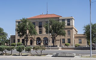
Pecos County is a county located in the U.S. state of Texas. As of the 2020 census, its population was 15,193. The county seat is Fort Stockton. The county was created in 1871 and organized in 1875. It is named for the Pecos River. It is one of the nine counties that comprise the Trans-Pecos region of West Texas.

Brewster County is a county located in the U.S. state of Texas. It is in West Texas and its county seat is Alpine. It is one of the nine counties that comprise the Trans-Pecos region, and borders Mexico. Brewster County is the largest county by area in the state - at 6,192 square miles (16,040 km2) it is over three times the size of the state of Delaware, and more than 500 square miles (1,300 km2) bigger than Connecticut.

Fort Stockton is a city in and the county seat of Pecos County, Texas, United States. It is located on Interstate 10, future Interstate 14, U.S. Highways 67, 285, and 385, and the Santa Fe Railroad, 329 mi (529 km) northwest of San Antonio and 240 mi (390 km) southeast of El Paso. Its population was 8,283 at the 2010 census.

The Waco Suspension Bridge crosses the Brazos River in Waco, Texas. It is a single-span suspension bridge, with a main span of 475 ft. Opened on November 20, 1869, it contains nearly 3 million bricks. It is located north of downtown Waco, connecting Indian Spring Park with Doris D. Miller Park. Every year on Independence Day, the bridge serves as a place where thousands of locals gather to watch fireworks. Indian Spring Park marks the location of the origin of the town of Waco, where the Huaco Indians had settled on the bank of the river, at the location of a cold spring.

Pecos National Historical Park is a United States National Historical Park in San Miguel County, New Mexico. The park, operated by the National Park Service, encompasses thousands of acres of landscape infused with historical elements from prehistoric archaeological ruins to 19th-century ranches, to a battlefield of the American Civil War. Its largest single feature is Pecos Pueblo also known as Cicuye Pueblo, a Native American community abandoned in historic times. First a state monument in 1935, it was made Pecos National Monument in 1965, and greatly enlarged and renamed in 1990. Two sites within the park, the pueblo and the Glorieta Pass Battlefield, are National Historic Landmarks.

Lyndon B. Johnson National Historical Park is a United States National Historical Park in central Texas about 50 miles (80 km) west of Austin in the Texas Hill Country. The park protects the birthplace, home, ranch, and grave of Lyndon B. Johnson, 36th president of the United States. During Johnson's administration, the LBJ Ranch was known as the Texas White House because the President spent approximately 20% of his time in office there.

State Highway 17 runs from Marfa to Pecos in west Texas. The road is maintained by the Texas Department of Transportation (TxDOT).
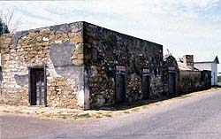
The Treviño–Uribe Rancho is a historic fortified home at the junction of Trevino and Uribe Streets in the small frontier town of San Ygnacio, Texas. With a construction history dating to 1830, it is one of the oldest surviving buildings from the period of Spanish-Mexican settlement of the north bank of the lower Rio Grande. The building was designated a National Historic Landmark in 1998.

The Glorieta Pass Battlefield was the site of an American Civil War battle that ended Confederate ambitions to cut off the West from the Union. The Battle of Glorieta Pass took place on March 26–28, 1862, at Glorieta Pass, on the Santa Fe Trail between the Pecos River and Santa Fe, New Mexico. The pass, and the battlefield, are now bisected by Interstate 25. Two portions of the battlefield, now publicly owned and operated by the National Park Service as part of Pecos National Historical Park, were declared a National Historic Landmark in 1961.
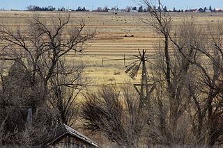
The Moriarty Eclipse Windmill is a historic windpump near Moriarty, New Mexico. The windpump was built in 1890 and added to the National Register of Historic Places in 1979.

Bethelem Lutheran Church is an historic stone Lutheran church located at 412 South White Street in Round Top, Texas.

Castolon, also known as La Harmonia Ranch and Campo Santa Helena, was a small community in southwestern Texas, located in what is now Big Bend National Park along the Rio Grande. The location was first settled in 1901 by Cipriano Hernandez, who farmed the area and built the original Castolon Store, now known as the Alvino House.

The Morris Ranch Schoolhouse is a ranch school located on Morris Ranch Road, 8.5 miles (13.7 km) southwest of Fredericksburg in Gillespie County, in the U.S. state of Texas. It was placed on the National Register of Historic Places in 1983, and was designated a Recorded Texas Historic Landmark in 1981. Designed by Alfred Giles, who also designed the 1882 Fredericksburg Memorial Library, the schoolhouse was built in 1893. Winning thoroughbred trainer Max Hirsch began his career on Morris Ranch and attended classes in the schoolhouse.
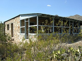
The Homer Wilson Ranch, also known as the Blue Creek Ranch, was one of the largest ranches in the early twentieth century in what would become Big Bend National Park in the U.S. state of Texas. The ranch was established by Homer Wilson in 1929 at Oak Springs to the west of the Chisos Mountains. Ultimately comprising 44 sections of land, amounting to more than 28,000 acres (11,000 ha), the Oak Canyon-Blue Creek Ranch was acquired by the State of Texas in 1942 for incorporation into the new park. A large portion of the ranch comprised portions of the old G4 Ranch, established by John and Clarence Gano in the 1880s. Wilson's ranch focused on sheep and goats, the first such large operation in the Big Bend area. Wilson continued to live at the ranch until his death in 1943; his family moved from the ranch the next year. Wilson, born in Del Rio, Texas in 1892, had studied petroleum engineering at the Missouri School of Mines and was a World War I veteran. The ranch, with the headquarters at Oak Springs and its operational center at Blue Creek, was one of the largest in Texas, and the most significant ranch in Big Bend.

Seminole Canyon State Park and Historic Site is a state park in the U.S. state of Texas. It is located off U.S. Route 90, east of the Pecos River High Bridge, 9 miles (14 km) west of Comstock in Val Verde County. The park is conducive to camping, biking, bird watching, back packing and archeological study. Cave art and archeological artifacts date back to the earliest human habitation in the area. The park is part of the larger Seminole Canyon Archeological District on the National Register of Historic Places.


