Bevagna is a town and comune in the central part of the Italian province of Perugia (Umbria), in the flood plain of the Topino river.
Cascia is a town and comune (municipality) of the Italian province of Perugia in a rather remote area of the mountainous southeastern corner of Umbria. It is about 21 km from Norcia on the road to Rieti in the Lazio (63 km). It is also very close to Terni.

Alvito is a town and comune in central Italy, in the province of Frosinone, south of Rome in the Lazio region. Its territory is included in the Abruzzo, Lazio and Molise National Park.

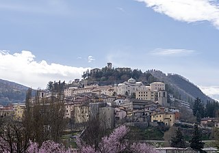
Monteleone di Spoleto, is a town and comune of Italy, in the province of Perugia in southeast Umbria at 978 meters (3209 ft) above sea-level overhanging the upper valley of the Corno River. It is one of the more remote towns in Umbria, on a mountain road from Norcia and Cascia to Leonessa and Rieti in the Lazio. It is a member of the I Borghi più belli d'Italia association.

Fossato di Vico is a town and comune of Umbria in the province of Perugia in Italy, at 581 m above sea‑level on the middle slopes of Mount Mutali.

Cerreto di Spoleto is an Italian village and comune of the province of Perugia in Umbria. It is a dispersed rural community with 1,158 inhabitants spread over 8 frazioni. Its claim to fame is to be the root of the English term "charlatan", as Cerreto was once widely known for the quacks among its natives.

Soriano nel Cimino is a town and comune in the province of Viterbo, Lazio, central Italy.
Paliano is a town and comune in the province of Frosinone, in the Lazio region of central Italy.
Cantalupo nel Sannio is a town and comune in the province of Isernia, in the Molise region of southern Italy.
Corciano is a comune (municipality) in the Province of Perugia in the Italian region Umbria, located about 8 km west of Perugia. As of 31 December 2004, it had a population of 17,008 and an area of 63.7 km². Corciano borders the comuni of Magione and Perugia. It is a member of the I Borghi più belli d'Italia association.
Montone is a comune (municipality) in the Province of Perugia in the Italian region Umbria, located about 35 km north of Perugia. It is a member of the I Borghi più belli d'Italia association.

Monteleone d'Orvieto is a comune (municipality) in the Province of Terni in the Italian region Umbria, located about 35 km southwest of Perugia and about 60 km northwest of Terni. It is a member of the I Borghi più belli d'Italia association.

Stroncone is a comune (municipality) in the Province of Terni in the Italian region Umbria, located about 70 km southeast of Perugia and about 8 km south of Terni. It is a member of the I Borghi più belli d'Italia association.

Casperia is a comune (municipality) in the Province of Rieti in the Italian region of Latium, located about 50 kilometres (31 mi) northeast of Rome and about 20 kilometres (12 mi) southwest of Rieti. As of 31 December 2004, it had a population of 1,164 and an area of 25.4 square kilometres (9.8 sq mi).

Fara in Sabina is a comune (municipality) in the Province of Rieti in the Italian region of Lazio, located about 40 kilometres (25 mi) northeast of Rome and about 25 kilometres (16 mi) southwest of Rieti.
Forano is a comune (municipality) in the Province of Rieti in the Italian region of Latium, located about 45 kilometres (28 mi) north of Rome and about 25 kilometres (16 mi) southwest of Rieti. As of 31 December 2004, it had a population of 2,697 and an area of 17.5 square kilometres (6.8 sq mi).

Magliano Sabina is a comune (municipality) in the Province of Rieti in the Italian region of Latium, located about 50 kilometres (31 mi) north of Rome and about 30 kilometres (19 mi) west of Rieti. As of 31 December 2004, it had a population of 3,829 and an area of 43.7 square kilometres (16.9 sq mi).
Poggio Catino is a comune (municipality) in the Province of Rieti in the Italian region of Latium, located about 45 kilometres (28 mi) northeast of Rome and about 20 kilometres (12 mi) southwest of Rieti. As of 31 December 2011, it had a population of 1,335 and an area of 15.0 square kilometres (5.8 sq mi).
Selci is a comune (municipality) in the Province of Rieti in the Italian region of Latium, located about 45 kilometres (28 mi) north of Rome and about 25 kilometres (16 mi) southwest of Rieti. As of 31 December 2004, it had a population of 1,038 and an area of 7.8 square kilometres (3.0 sq mi).

Montelibretti is a town and comune (municipality) in the Metropolitan City of Rome in the Italian region of Lazio, located about 30 kilometres (19 mi) northeast of Rome on the slopes of Monti Sabini.