Cantonment Hill, Fremantle

Last updated

Cantonment Hill
Dwerda Weelardinup, Walyarup
Cantonment hill gnangarra-103.jpg
Cantonment Hill signal station
Coordinates: 32°2′37″S115°45′19″E / 32.04361°S 115.75528°E / -32.04361; 115.75528
Location Fremantle, Western Australia
OperatorCity of Fremantle
Area
  Total2.31 hectares (5.7 acres)
Elevation33.9 m (111.2 ft)
Cantonment Hill, Fremantle

Cantonment Hill is a small rise overlooking the port city of Fremantle, Western Australia. Since the early 1900s the hill and the surrounding 4-hectare (9.9-acre) precinct has been mainly used for military purposes with extensive buildings now present. It has been under the control of the Department of Defence.

Contents

The area is known by the indigenous Whadjuk people as Dwerda Weelardinup, meaning "place of the dingo spirit" and the peak is also referred to as Walyarup, meaning "sea-eagle nest". [1]

The site includes the last remaining stand of pre-European settlement Rottnest Island pine ( Callitris preissii ) on the mainland of Western Australia. [2]

Site

Cantonment Hill from the air, showing the Navy warehouse, signal station, and Tuckfield Oval. Cantonment Hill aerial photograph.jpg
Cantonment Hill from the air, showing the Navy warehouse, signal station, and Tuckfield Oval.

The Cantonment Hill site consists of a number of properties, lots 600, 601, 604 are owned by the Commonwealth Government lot 601 is the site of Army Museum of Western Australia, lot 603 is privately owned. Lot 602 which consists of two parts totalling 1.4675 hectares (3.626 acres), lot 50 is between these two parts covers an area 0.8432 hectares (2.084 acres). The approximately 4 hectares (9.9 acres) site is bounded by Canning Highway, Queen Victoria Street, Burt Street and Tuckfield Street. There are a number of buildings within the site besides those of the Army museum: there is the heritage listed former defense housing on Queen Victoria Street, the heritage listed Naval Store (1935 [3] ) on the Corner of Queen Victoria Street and Canning Highway, and a signal station built for the Fremantle Harbour Trust in 1956. [1]

In the mid-1990s a group of local residents formed the Cantonment Hill Residents Action Group for the return of site to the City of Fremantle as per the original gift of 1892. In this Lot 50 was set aside as a Bush Forever site previously identified in 1981 by the Environmental Protection Agency. In 1989 and again in 1996 surveys of the area identified 20 native plants and 27 weeds. Included in the native plants is the only remaining natural occurrence of Rottnest Island pine (Callitris preissii) on the mainland. The 1989 survey also identified 16 bird species and 2 reptile species. [1]

History

For many thousands of years before European settlement, Cantonment Hill was a place of significance to the local Whadjuk people who are part of the Noongar people. They told stories about the site, and camped there. The site was known as Dwerda Weelardinup, meaning "place of dingo spirit". Other families also called the site Walyarup which means Sea Eagle nest. In 1829, Europeans established the Swan River Colony and the town of Fremantle. It is from the cantonment established nearby that its common name is taken. The site was a popular destination for picnics for the settlers due to the views over Fremantle, the river and ocean. [1]

When the Colonial Government established Rottnest Island as a prison for indigenous people, their families would gather on Sundays to send signals to those on the island using fire. These fires also aided those who attempted to escape from the Island. In 1830, Ensign Robert Dale, who was working for Surveyor General John Septimus Roe, sketched Fremantle from Cantonment Hill. This is one of the earliest depictions of Fremantle. Cantonment Hill remained relatively unchanged during Fremantle's early development, though in 1877 some limestone was quarried from the hill. [1]

In 1833, the hill was the site of Western Australia's only duel. [4]

During the 1880s, residents of the Fremantle area urged the Fremantle Municipality to request the land be vested from the Crown for public space. [5] In 1892 it was given by the Crown to the City of Fremantle in perpetuity "for the purposes of a public garden". [2]

The Artillery Barracks in Burt Street were built on the site between 1910 and 1913 for Royal Australian Garrison Artillery, who manned the coastal defence batteries at Fort Arthur Head and Fort Forrest (North Fremantle). [6] [7] During World War I the site was used as a rehabilitation hospital for injured soldiers returning from the Western Front and later as an internment camp and as a quarantine station.

In 1931, as part of the City of Fremantle's employment for sustenance to those left unemployed by the Depression, a section of the land was cleared and levelled to make a park. Additionally a path was provided for the residents of Tuckfield, giving them direct access to Queen Victoria Bridge. [8] This area is eastern lot 602, known as Tuckfield Oval and used as playing fields by schools until the 1990s.

During World War II further development at the site saw construction of a tunnel network to an underground control room and a large warehouse on the north-eastern side. This latter was constructed after 1935 [9] and bears US Navy insignia and the motto non sibi sed patriæ , but is not listed among the facilities used by that navy during World War II. [10] By the early 1950s, the property ceased to be used as military barracks but remained under Defence control. The artillery barracks buildings were used from 1948 onwards as a training venue for the Army Reserve and in 1995 the Army Museum of Western Australia moved to the site, where they currently remain. The barracks are the oldest continuously occupied defence site in Western Australia.

Signal station

Signal station, with mural by Nami Osaki Cantonment hill gnangarra-104.jpg
Signal station, with mural by Nami Osaki

In early 1929 a signal station was constructed on the peak of Cantonment Hill to replace the station that had operated at Arthur Head. [11] The station opened on 8 May 1929 when at 7:40 am signalman Edward Ray raised the first ball for SS Gascoyne. [12] Ray retired in 1941 after 44 years service, 39 of them at Fremantle. [13] This station was replaced with a masonry building by the Harbour Trust in 1956 providing commanding views across to Rottnest Island. [14] [15] The signal station closed in 1964 when it was replaced by the Port of Fremantle's new building on Victoria Quay. [1]

Return to public ownership

In 1989 the Department of Defence mooted plans to dispose of the property. [16] Options considered have been the sale of the property to Notre Dame University and a transfer to the Government of Western Australia by way of a Centenary of Federation of Australia gift from the Federal Government. Progress in negotiations was stalled however, as the parties have requested the Commonwealth to provide funding to reinstate the site to a usable condition—then Premier Geoff Gallop announced in September 2003 that the Government had formally declined the offer.

Since 1997, a community-based Cantonment Hill Residents Action Group has lobbied for its return to the City according to the original gift and its restoration and retention as public property with full public access.

On 21 January 2010, the Prime Minister announced that Cantonment Hill, including Tuckfield Oval, would be sold back to the people of Fremantle. [17] The council was to reportedly pay $76,000 for the land, and had plans to rehabilitate the vegetation and build walking paths and picnic facilities. The signal station was to have been turned into a café and Aboriginal interpretive centre. The handover was to have been completed by March 2010. [18]

In December 2012 the City of Fremantle re-established the Cantonment Hill Working Group, consisting of councillors including the mayor Dr Brad Pettitt, a representative of the city's CEO and five residents. This same group was responsible for the development of a master plan for the site as well previous works to clean up the area along restoration of the area. [19]

At the beginning of February 2015, it was reported that Fremantle Sea Rescue would likely become based in the signal station. This drew criticism from members of the Cantonment Hill Working Group who had developed the master plan for the site which the City of Fremantle had previously given assurances to implement. [20] In late March 2015 draft plans were presented at a council meeting detailing the creation of a convention center and restaurant for the site, with the FSR suggested as being a medium-term occupant while this larger plan came to fruition. [21] [22]

A mega mural was installed on the top floor of the signal station in March 2015; the mural is part of the City of Fremantle's cultural development plan. The mural by artist Nami Osaki depicts a girl and dingo in a Japanese manga style reflecting the site's indigenous history. It wraps around the whole building, with the girl positioned so as to be peering out over the river while she sits with her dingo at a camp fire. [23]

Related Research Articles

<span class="mw-page-title-main">Fremantle</span> Port city in Western Australia

Fremantle is a port city in Western Australia, located at the mouth of the Swan River in the metropolitan area of Perth, the state capital. Fremantle Harbour serves as the port of Perth. The Western Australian vernacular diminutive for Fremantle is Freo.

<span class="mw-page-title-main">Rottnest Island</span> Island off the coast of Western Australia

Rottnest Island, often colloquially referred to as "Rotto", is a 19 km2 (7.3 sq mi) island off the coast of Western Australia, located 18 km (11 mi) west of Fremantle. A sandy, low-lying island formed on a base of aeolianite limestone, Rottnest is an A-class reserve, the highest level of protection afforded to public land.

<span class="mw-page-title-main">Cottesloe, Western Australia</span> Suburb of Perth, Western Australia

Cottesloe is a western suburb of Perth, Western Australia, within the Town of Cottesloe. Cottesloe was named for Thomas Fremantle, 1st Baron Cottesloe, a prominent Tory politician and the brother of Admiral Sir Charles Fremantle for whom the city of Fremantle was named. The nearby suburb of Swanbourne was named for the Fremantle family seat, Swanbourne House, in Swanbourne, Buckinghamshire.

The Fremantle line is a suburban railway and service in Western Australia that connects the central business district (CBD) of Perth with Fremantle.

<span class="mw-page-title-main">Army Museum of Western Australia</span> Military museum in Fremantle, Western Australia

The Army Museum of Western Australia is a museum located in an historic artillery barracks on Burt Street in Fremantle, Western Australia. The museum was established in 1977 and has three Victoria Crosses on display.

<span class="mw-page-title-main">Mosman Park, Western Australia</span> Suburb of Perth, Western Australia

Mosman Park is a western suburb of Perth, Western Australia on the north bank of the Swan River in the local government area of the Town of Mosman Park. It was historically known as Buckland Hill (1889–1909), then Cottesloe Beach (1909–1930) and again Buckland Hill (1930–1937). From 1937 it was named Mosman Park, derived from Mosman in Sydney, the birthplace of Richard Yeldon, a member of the Buckland Hill Road Board. Mosman Park is now considered an affluent suburb, but prior to the 1970s was one of Perth's major industrial centres.

<span class="mw-page-title-main">Queen Victoria Street, Fremantle</span> Road in Fremantle, Western Australia

Queen Victoria Street is the main road entering the city centre of Fremantle, Western Australia from the direction of Perth. The road was originally named Cantonment Road, but was subsequently renamed Victoria Road, and a few years later Queen Victoria Street, after Queen Victoria of the United Kingdom, to avoid confusion with similarly named roads in the area.

<span class="mw-page-title-main">Challenger Harbour</span> Boat harbour in Fremantle, Western Australia

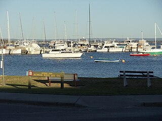
Challenger Harbour is a marina in Fremantle, Western Australia adjacent to the Fremantle Fishing Boat Harbour. The harbour breakwater covers the historical site of the Fremantle Long Jetty.

<span class="mw-page-title-main">Fremantle Harbour</span> Port in Fremantle, Western Australia

Fremantle Harbour is Western Australia's largest and busiest general cargo port and an important historical site. The inner harbour handles a large volume of sea containers, vehicle imports and livestock exports, cruise shipping and naval visits, and operates 24 hours a day. It is located adjacent to the city of Fremantle, in the Perth metropolitan region.

<span class="mw-page-title-main">Wadjemup Lighthouse</span> Lighthouse on Rottnest Island, Western Australia

Completed in 1849, the original 20-metre (66 ft) Wadjemup Lighthouse was Western Australia's first stone lighthouse and was built to provide a safer sailing passage for ships to Fremantle Port and the Swan River Colony.

<span class="mw-page-title-main">Geography of Rottnest Island</span> Features of Rottnest Island, Western Australia

Rottnest Island lies 18 kilometres (11 mi) west of the coastline of Perth, Western Australia; it is 4.5 kilometres (2.8 mi) at its widest and 11 kilometres (6.8 mi) at its longest.

<span class="mw-page-title-main">Old Fremantle Police Station and Court House Complex</span> Heritage listed building in Fremantle, Western Australia

The Old Fremantle Police Station and Court House Complex is a heritage-listed group of buildings located at 45 Henderson Street, Fremantle, Western Australia. The complex includes the former courthouse, police station, police barracks and lock-up and artillery drill hall.

<span class="mw-page-title-main">Kings Square, Fremantle</span> Town square in Fremantle, Western Australia

Walyalup Koort, formerly known as Kings Square (or King's Square), is a town square in Fremantle, Western Australia. It is bounded by Queen, Newman, William, and Adelaide Streets. Though the square was originally a public reserve, it has been the site of Saint John's Church of England since 1843, and the Fremantle Town Hall since 1887. High Street was extended through and beyond the square in the 1880s, but the portion through the square was closed off in the 1960s. Today Kings Square functions as a civic and cultural centre of Fremantle, with modern events taking place adjacent to the historic buildings.

<span class="mw-page-title-main">Irwin Barracks</span>

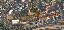
Irwin Barracks is an Australian Army military base located in Karrakatta, a suburb of Perth, Western Australia. It occupies a 62-hectare (150-acre) site on the western side of the Fremantle railway line.

<span class="mw-page-title-main">Burt Street, Fremantle</span> Street in Fremantle, Western Australia

Burt Street is a street located in Fremantle, Western Australia. It runs between Queen Victoria Street and East Street and rises up the prominent hill that lies to the south of Cantonment Hill.

The Fremantle Volunteer Sea Rescue Group Inc, or Fremantle Sea Rescue (FSR), is a volunteer lead marine search and rescue service based in Fremantle, Western Australia. It operates continuously and responds to approximately 700 incidents a year. It is one of 39 sea rescue services recognised by the Department of Fire and Emergency Services, who between them cover over 13,000 kilometres (8,100 mi) of the Western Australian coast. Fremantle Sea Rescue was established in 1977. Prior to 1975 there was no formal sea rescue service operating in WA. Following an incident in 1972 when two people drowned after their boat hit a submerged object, at the insistence of East Fremantle Yacht Club, yacht clubs in the Perth area formed the Volunteer Sea Search and Rescue Association (WA) in 1975. It was from this organisation that the Fremantle Sea Rescue Service was formed.

<span class="mw-page-title-main">Leighton Battery</span> Heritage listed military installation in Mosman Park, Western Australia

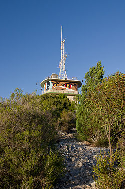
Leighton Battery at Buckland Hill, Mosman Park, Western Australia, was part of the Coastal defences of Australia during World War II and the Fremantle Fortress, protecting Fremantle Harbour.

<span class="mw-page-title-main">Fremantle Fortress</span> Second World War naval defence system for Perth, Western Australia

Fremantle Fortress was the combined coastal defences protecting the harbour of Fremantle, Western Australia, since the mid-1930s and, predominantly, during World War II. The coastal defences of the Fremantle Fortress stretched along the coastline of Perth from Cape Peron to Swanbourne and also included installations on Garden Island and Rottnest Island. While the first coastal batteries of the future Fremantle Fortress were installed at Arthur Head in 1906, the military installations protecting the harbour were expanded in the 1930s, being eventually dismantled again by 1963.

<span class="mw-page-title-main">Peron Battery</span> Heritage listed World War II fortification in Western Australia

The Peron Battery, at Cape Peron, was the southernmost of the Fremantle Fortress coastal defence batteries in Western Australia. Also referred to as K Heavy Battery, it was established in January 1943 and, like the Challenger Battery on near-by Garden Island, it was equipped with two mobile 155mm guns. Additionally, it also operated two 18-pounder guns which were withdrawn once the Collie Secondary Battery became operational on Garden Island. The duty of the main guns was to cover the southern access to Cockburn Sound while the 18-pounder guns protected the a boom net which spanned between Cape Peron and Garden Island. The main battery was withdrawn again in December 1944 but the observation post and one of the Panama mounts of the Peron Battery are still preserved and accessible.

References

  1. 1 2 3 4 5 6 "Cantonment Hill Master plan". City of Fremantle. 18 June 2012. Archived from the original on 22 March 2015. Retrieved 30 May 2015.
  2. 1 2 Speech by Melissa Parke, Member for Fremantle (4 December 2008). "Cantonment Hill". openaustralia.org. Retrieved 13 October 2010.
  3. "New Building for Naval Department". The Daily News (City Final ed.). Perth, WA. 14 August 1935. p. 5. Retrieved 30 May 2015 via National Library of Australia.
  4. "Pistols For Two". The West Australian . Vol. XLIX, no. 9, 524. Western Australia. 5 January 1933. p. 17. Retrieved 16 June 2017 via National Library of Australia.
  5. "Fremantle Municipality". The Daily News . Perth, WA. 9 September 1886. p. 3. Retrieved 30 May 2015 via National Library of Australia.
  6. "New Military Barracks at Fremantle". Western Mail . Perth, WA. 8 April 1911. p. 27. Retrieved 30 May 2015 via National Library of Australia.
  7. "Artillery Barracks". Army Museum of Western Australia. Archived from the original on 29 May 2015. Retrieved 29 December 2008.
  8. "City Improvements". Sunday Times . Perth, WA. 1 February 1931. p. 12. Retrieved 30 May 2015 via National Library of Australia.
  9. "Naval Stores, 141 Queen Victoria Street" . Retrieved 23 October 2018.
  10. Base Facilities Report  . 1944 via Wikisource.
  11. "Pickings from the Port". Sunday Times . Perth, WA. 14 April 1929. p. 3. Retrieved 30 May 2015 via National Library of Australia.
  12. "Persons in the News". The Daily News . Perth, WA. 7 May 1929. p. 1. Retrieved 30 May 2015 via National Library of Australia.
  13. "Long watch ends". The West Australian . Perth, WA. 9 January 1941. p. 6. Retrieved 30 May 2015 via National Library of Australia.
  14. "A fisherman pilot". The West Australian . Perth, WA. 13 May 1930. p. 16. Retrieved 30 May 2015 via National Library of Australia.
  15. "Information Sheet - Fremantle Artillery Barracks Feasibility Study Project" (PDF). City of Fremantle. Retrieved 31 December 2008.
  16. "Proposal to Sell". Army museum of Western Australia. Archived from the original on 19 July 2008. Retrieved 2008-12-29.
  17. Prime Minister, Kevin Rudd; Minister for Finance, Lindsay Tanner; Member for Fremantle, Melissa Parke (21 January 2010). "Cantonment Hill returned to the people of Fremantle". Australian Government. Retrieved 28 January 2010.
  18. D'Anger, Jenny (23 January 2010). "Cantonment Hill victory for Freo". Fremantle Herald.
  19. "Cantonment Hill Working Group". City of Fremantle. City of Fremantle. Archived from the original on 22 March 2015. Retrieved 29 May 2015.
  20. Mitchell, Brian (2 February 2015). "Sea Rescue Station for Signal Station". The Fremantle Herald.
  21. Grant, Steve (28 March 2015). "Heartbreak Hill". Fremantle Herald.
  22. Loopers, Roel. "Community Consultation Just Ticking a Box in Freo". Freo's View. Retrieved 29 May 2015.
  23. "Mega mural watches over Fremantle from Cantonment Hill". City of Fremantle. Retrieved 30 May 2015.