 Cape Agulhas Lighthouse | |
 | |
| Location | L'Agulhas, Western Cape, South Africa |
|---|---|
| Coordinates | 34°49′46″S20°00′32″E / 34.829389°S 20.008911°E |
| Tower | |
| Constructed | 1848 (first lit 1849) |
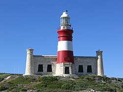
| Construction | sandstone tower |
| Height | 27 m (89 ft) |
| Shape | cylindrical tower with balcony and lantern rising from one-story keeper's house |
| Markings | red tower with a white band, white lantern |
| Power source | mains electricity |
| Operator | South African National Parks [1] |
| Heritage | Historic Civil Engineering Landmark |
| Light | |
| First lit | 1 March 1849 |
| Deactivated | 1968–1988 |
| Focal height | 31 m (102 ft) |
| Lens | 1st order Fresnel |
| Intensity | 7,500,000 cd |
| Range | 30 nmi (56 km; 35 mi) |
| Characteristic | Fl W 5s |
The Cape Agulhas Lighthouse is at Cape Agulhas, the southernmost tip of Africa. At 171 years old, it is the third-built lighthouse in South Africa, and the second-oldest still operating, after Green Point. [2] It is located on the southern edge of the village of L'Agulhas, in the Agulhas National Park; the light is operated by Transnet National Ports Authority. In 2016, the American Society of Civil Engineers (ASCE) identified the lighthouse as a deserving prominent historic engineering project and International Historic Civil Engineering Landmark.
