
The Delmarva Peninsula, or simply Delmarva, is a large peninsula and proposed state on the East Coast of the United States, occupied by the vast majority of the state of Delaware and parts of the Eastern Shore regions of Maryland and Virginia. The peninsula is 170 miles (274 km) long. In width, it ranges from 70 miles (113 km) near its center, to 12 miles (19 km) at the isthmus on its northern edge, to less near its southern tip of Cape Charles. It is bordered by the Chesapeake Bay on the west, Pocomoke Sound on the southwest, and the Delaware River, Delaware Bay, and the Atlantic Ocean on the east.

Somerset County is the southernmost county in the U.S. state of Maryland. As of the 2020 census, the population was 24,620, making it the second-least populous county in Maryland. The county seat is Princess Anne.

Northampton County is a county located in the Commonwealth of Virginia. As of the 2020 census, the population was 12,282. Its county seat is Eastville. Northampton and Accomack Counties are a part of the larger Eastern Shore of Virginia.

Cape Charles is a town / municipal corporation in Northampton County, Virginia, United States. The population was 1,009 as of the 2010 Census.

The Virginia Capes are the two capes, Cape Charles to the north and Cape Henry to the south, that define the entrance to Chesapeake Bay on the eastern coast of North America.

Korea(n) Bay, sometimes West Korea(n) Bay, is a bight and the northern extension of the Yellow Sea, between the southeastern coastline of China's Liaoning Province and the western coastline of North Korea's North Pyongan, South Pyongan and South Hwanghae provinces. It is separated from the Bohai Sea by the Liaodong Peninsula, with Dalian's Lüshunkou District marking its western end, and westernmost tip of North Korea's Ryongyon County as its eastern end.
The Eastern Shore of Virginia consists of two counties on the Atlantic coast detached from the mainland of the Commonwealth of Virginia in the United States. The 70-mile-long (110 km) region is part of the Delmarva Peninsula and is separated from the rest of Virginia by the Chesapeake Bay. Its population was 45,695 as of 2020.
Cape Henry is a cape on the Atlantic shore of Virginia located in the northeast corner of Virginia Beach. It is the southern boundary of the entrance to the long estuary of the Chesapeake Bay.

State Route 184 is a primary state highway in the U.S. state of Virginia. The state highway runs 3.20 miles (5.15 km) from Washington Avenue and Bay Street in Cape Charles east to U.S. Route 13 and US 13 Business near Bayview. SR 184 connects US 13 with Cape Charles in southern Northampton County. The state highway is the old alignment of US 13 from when the U.S. highway used the Little Creek-Cape Charles Ferry to cross the Chesapeake Bay to Norfolk. SR 184 was designated after US 13 was extended south to the new terminal of the Little Creek Ferry at Kiptopeke and later the Chesapeake Bay Bridge-Tunnel.
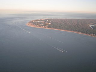
Kiptopeke State Park is a state park located in the southern end of the Eastern Shore of Virginia and the Delmarva Peninsula in Northampton County, near Cape Charles. From 1949, the site was owned by the Virginia Ferry Corporation and used through 1964 as the northern terminus for the Little Creek-Cape Charles Ferry service which crossed the lower Chesapeake Bay from the Eastern Shore / Delmarva to Norfolk and Hampton Roads harbor on the Western Shore. In 1964, the ferry service was replaced by the Chesapeake Bay Bridge-Tunnel which opened up giving automobile traffic convenient access to the park, the Cape, Delmarva and "The Shore" to the urban centers to the west in North Carolina, Virginia, Maryland and the District of Columbia.
Babbacombe Bay is a South-East Devon shallow, wide, continuation of the main sweep of Lyme Bay which, in turn, to the east is the western end of the Jurassic Coast in England, UK. It faces east towards the parent, notably large bay of the English Channel, weakly sheltered from large tides from the east but much so from Atlantic tides, currents and storms from the west. As a sub-bay it covers about 4.5 miles (7.2 km). It is bounded by:

Nipe Bay is a bay on the northern coast of Cuba in Holguín Province, part of the former Oriente Province. It is part of the municipalities of Mayarí and Antilla.
Bullbegger is an unincorporated community in Accomack County, Virginia, United States.
Mishaum Point is the southernmost point of Bristol County in southeastern Massachusetts.Mishaum Point is a private gated. It extends into Buzzards Bay.

Leadbetter Point is a point on the northwest coast of Pacific County in the state of Washington in the United States. It lies at the southern side of the entrance to Willapa Bay.
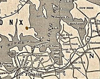
Little Neck Bay is an embayment in western Long Island, New York, off Long Island Sound. Little Neck Bay forms the western boundary of the Great Neck Peninsula, the eastern boundary of which is Manhasset Bay. The political boundary between Nassau County and the borough of Queens runs through the bay, bordering the neighborhood of Douglaston–Little Neck.
Cape San Antonio, or in Spanish Cabo San Antonio, is a cape extending into the Atlantic Ocean on the eastern coast of Buenos Aires Province in eastern Argentina. It lies south of Samborombón Bay.
Bloodsworth Island is an island in the Chesapeake Bay. It lies in southern Dorchester County, Maryland. Historic research suggests that sites discovered in an archaeological investigation of the northern third of the island were associated with families who worked in the nineteenth-century Chesapeake Bay oystering industry.
Oyster Bay, also known as Oyster Bay Harbor, is an inlet of Long Island Sound on the north shore of Long Island in New York in the United States.
Corson Inlet is a narrow strait on the southern coast of New Jersey in the United States.
