
The North Pole, also known as the Geographic North Pole, Terrestrial North Pole or 90th Parallel North, is the point in the Northern Hemisphere where the Earth's axis of rotation meets its surface. It is called the True North Pole to distinguish from the Magnetic North Pole.

Robert Edwin Peary Sr. was an American explorer and officer in the United States Navy who made several expeditions to the Arctic in the late 19th and early 20th centuries. He was long credited as being the discoverer of the geographic North Pole in April 1909, having led the first expedition to have claimed this achievement, although it is now considered unlikely that he actually reached the Pole.

Ellesmere Island is Canada's northernmost and third largest island, and the tenth largest in the world. It comprises an area of 196,236 km2 (75,767 sq mi), slightly smaller than Great Britain, and the total length of the island is 830 km (520 mi).
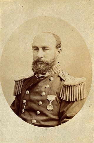
Vice-Admiral Sir George Strong Nares was a Royal Navy officer and Arctic explorer. He commanded the Challenger Expedition, and the British Arctic Expedition. He was highly thought of as a leader and scientific explorer. In later life he worked for the Board of Trade and as Acting Conservator of the River Mersey.

Cape Morris Jesup is a headland in Peary Land, Greenland.

Frederick Albert Cook was an American explorer, physician and ethnographer, who is most known for allegedly being the first to reach the North Pole on April 21, 1908. A competing claim was made a year later by Robert Peary, though both men's accounts have since been fiercely disputed; in December 1909, after reviewing Cook's limited records, a commission of the University of Copenhagen ruled his claim unproven. Nonetheless, in 1911, Cook published a memoir of the expedition in which he maintained the veracity of his assertions. In addition, he also claimed to have been the first person to reach the summit of Denali, the highest mountain in North America, a claim which has since been similarly discredited. Though he may not have achieved either Denali or the North Pole, his was the first and only expedition where a United States national discovered an Arctic island, Meighen Island.

Lincoln Sea is a body of water in the Arctic Ocean, stretching from Cape Columbia, Canada, in the west to Cape Morris Jesup, Greenland, in the east. The northern limit is defined as the great circle line between those two headlands. It is covered with sea ice throughout the year, the thickest sea ice in the Arctic Ocean, which can be up to 15 m (49 ft) thick. Water depths range from 100 m (330 ft) to 300 m (980 ft). Water and ice from Lincoln Sea empty into Robeson Channel, the northernmost part of Nares Strait, most of the time.

Peary Land is a peninsula in northern Greenland, extending into the Arctic Ocean. It reaches from Victoria Fjord in the west to Independence Fjord in the south and southeast, and to the Arctic Ocean in the north, with Cape Morris Jesup, the northernmost point of Greenland's mainland, and Cape Bridgman in the northeast.
Cape Sheridan is on the northeastern coast of Ellesmere Island, Canada situated on the Lincoln Sea in the Arctic Ocean, on the mouth of Sheridan River, west bank. It is one of the closest points of land to the geographic North Pole, approximately 840 km (520 mi) to the north, Cape Columbia is however some 75 km (47 mi) closer to the Pole.

The British Arctic Expedition of 1875–1876, led by Sir George Nares, was sent by the British Admiralty to attempt to reach the North Pole via Smith Sound on the west coast of Greenland.

Ward Hunt Island is a small, uninhabited island in the Arctic Ocean, located off the north coast of Ellesmere Island near the Ward Hunt Ice Shelf. The island is located just 750 km (470 mi) from the geographical North Pole. The northern cape of Ward Hunt Island is one of the northernmost elements of land in Canada. Only a 17 km (11 mi) stretch of northern coast of Ellesmere Island around Cape Columbia is more northerly. The island is 5.0 km (3.1 mi) long, east to west, and 3.0 km (1.9 mi) wide. The first known sighting was in 1876 by Pelham Aldrich, a lieutenant with the George Nares expedition, and named for George Ward Hunt, who was First Lord of the Admiralty at the time (1874–1877). Today, the Island is part of the Quttinirpaaq National Park.

Farthest North describes the most northerly latitude reached by explorers, before the first successful expedition to the North Pole rendered the expression obsolete. The Arctic polar regions are much more accessible than those of the Antarctic, as continental land masses extend to high latitudes and sea voyages to the regions are relatively short.
The Arctic Ocean is the smallest and shallowest of the world's five oceanic divisions. It spans an area of approximately 14,060,000 km2 (5,430,000 sq mi) and is known as one of the coldest of oceans. The International Hydrographic Organization (IHO) recognizes it as an ocean, although some oceanographers call it the Arctic Mediterranean Sea. It has also been described as an estuary of the Atlantic Ocean. It is also seen as the northernmost part of the all-encompassing world ocean.
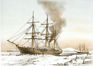
HMS Alert was a 17-gun wooden screw sloop of the Cruizer class of the Royal Navy, launched in 1856 and broken up in 1894. She was the eleventh ship of the Royal Navy to bear the name, and was noted for her Arctic exploration work; in 1876 she reached a record latitude of 82° North. Alert briefly served with the US Navy, and ended her career with the Canadian Marine Service as a lighthouse tender and buoy ship.
HMS Discovery was a wood-hulled screw expedition ship, and later storeship, formerly the sealing ship Bloodhound built in 1873 in Dundee. She was purchased in 1874 for the British Arctic Expedition of 1875–1876 and later served as a store ship. Discovery was sold in 1902, reverting to the name Bloodhound and her previous sealing trade. The ship was wrecked in Newfoundland in 1917.
The Peary Arctic Club was an American-based club with the goal of promoting the Arctic expeditions of Robert Peary (1856–1920).
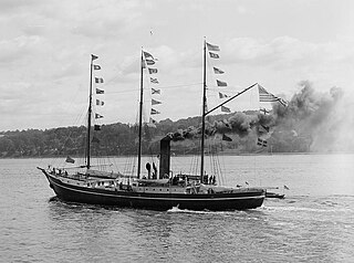
SS Roosevelt was an American steamship of the early 20th century. She was designed and constructed specifically for Robert Peary′s polar exploration expeditions, and she supported the 1908 expedition in which he claimed to have discovered the North Pole.

The Roosevelt Range or Roosevelt Mountains is a mountain range in Northern Greenland. Administratively this range is part of the Northeast Greenland National Park. Its highest peak is the highest point in Peary Land.

The H. H. Benedict Range or H. H. Benedict Mountains is a mountain range in Peary Land, Northern Greenland. Administratively this range is part of the Northeast Greenland National Park.
 Pack ice of the Arctic Ocean accumulates off Cape Columbia. The Twin Otter airplane stands on the fast ice between the stacked pack ice (right) and the mainland
 Ice pressure ridges of the Arctic Ocean off Cape Columbia
 Map of Cape Columbia and the Lincoln Sea


