Carthage was an ancient city in Northern Africa, on the eastern side of the Lake of Tunis in what is now Tunisia. Carthage was one of the most important trading hubs of the Ancient Mediterranean and one of the most affluent cities of the classical world. It became the capital city of the civilisation of Ancient Carthage and later Roman Carthage.

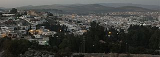
Tunis is the capital and largest city of Tunisia. The greater metropolitan area of Tunis, often referred to as "Grand Tunis", has about 2,700,000 inhabitants. As of 2020, it is the third-largest city in the Maghreb region and the eleventh-largest in the Arab world.

Utica was an ancient Phoenician and Carthaginian city located near the outflow of the Medjerda River into the Mediterranean, between Carthage in the south and Hippo Diarrhytus in the north. It is traditionally considered to be the first colony to have been founded by the Phoenicians in North Africa. After Carthage's loss to Rome in the Punic Wars, Utica was an important Roman colony for seven centuries.
Béja is a city in Tunisia. It is the capital of the Béja Governorate. It is located 105 kilometers (65 mi) from Tunis, between the Medjerdah River and the Mediterranean, against the foothills of the Khroumire, the town of Béja is situated on the sides of Djebel Acheb, facing the greening meadows, its white terraces and red roofs dominated by the imposing ruins of the old Roman fortress.

The Medjerda River, the classical Bagrada, is a river in North Africa flowing from northeast Algeria through Tunisia before emptying into the Gulf of Tunis and Lake of Tunis. With a length of 450 km (280 mi), it is the longest river of Tunisia. It is also known as the Wadi Majardah or Mejerda.
The Battle of Porto Farina took place at Porto Farina on 4 April 1655 in northern Tunisia, when an English fleet under General-at-Sea Robert Blake destroyed the vessels of several Barbary corsairs. Blake's fleet destroyed two shore batteries and nine Algerian ships in Porto Farina, the first time shore batteries had been taken out without landing men ashore.

Ghar el-Melh, the classical Rusucmona and Castra Delia and colonial Porto Farina, is a town and former port on the southern side of Cape Farina in Bizerte Governorate, Tunisia.

La Marsa is a coastal city located in the northeastern part of Tunisia, situated along the Mediterranean Sea. It is part of the Tunis Governorate and has a population of around 100,000 people. The city is known for its beaches, upscale residential areas, and lively atmosphere, with numerous restaurants, cafes, and shops. It is connected to Tunis by the TGM railway. Gammarth is adjacent to El Marsa further up the coast.

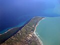
Cape Bon, also known as Res et-Teib, Shrīk Peninsula, or Watan el Kibli, is a peninsula in far northeastern Tunisia. Cape Bon is also the name of the northernmost point on the peninsula, also known as Res ed-Der, and known in antiquity as the Cape of Mercury or Cape Hermaeum.

The Punic religion, Carthaginian religion, or Western Phoenician religion in the western Mediterranean was a direct continuation of the Phoenician variety of the polytheistic ancient Canaanite religion. However, significant local differences developed over the centuries following the foundation of Carthage and other Punic communities elsewhere in North Africa, southern Spain, Sardinia, western Sicily, and Malta from the ninth century BC onward. After the conquest of these regions by the Roman Republic in the third and second centuries BC, Punic religious practices continued, surviving until the fourth century AD in some cases. As with most cultures of the ancient Mediterranean, Punic religion suffused their society and there was no stark distinction between religious and secular spheres. Sources on Punic religion are poor. There are no surviving literary sources and Punic religion is primarily reconstructed from inscriptions and archaeological evidence. An important sacred space in Punic religion appears to have been the large open air sanctuaries known as tophets in modern scholarship, in which urns containing the cremated bones of infants and animals were buried. There is a long-running scholarly debate about whether child sacrifice occurred at these locations, as suggested by Greco-Roman and biblical sources.

The city of Carthage was founded in the 9th century BC on the coast of Northwest Africa, in what is now Tunisia, as one of a number of Phoenician settlements in the western Mediterranean created to facilitate trade from the city of Tyre on the coast of what is now Lebanon. The name of both the city and the wider republic that grew out of it, Carthage developed into a significant trading empire throughout the Mediterranean. The date from which Carthage can be counted as an independent power cannot exactly be determined, and probably nothing distinguished Carthage from the other Phoenician colonies in Northwest Africa and the Mediterranean during 800–700 BC. By the end of the 7th century BC, Carthage was becoming one of the leading commercial centres of the West Mediterranean region. After a long conflict with the emerging Roman Republic, known as the Punic Wars, Rome finally destroyed Carthage in 146 BC. A Roman Carthage was established on the ruins of the first. Roman Carthage was eventually destroyed—its walls torn down, its water supply cut off, and its harbours made unusable—following its conquest by Arab invaders at the close of the 7th century. It was replaced by Tunis as the major regional centre, which has spread to include the ancient site of Carthage in a modern suburb.
The delegations of Tunisia are the second level administrative divisions of Tunisia between the governorates and the sectors (imadats). As of 2006 there were 24 governorates which were divided into 264 delegations and further divided into 2073 sectors. The delegations are listed below, organized by governorate.

The following outline is provided as an overview of and topical guide to Tunisia:

Soliman, Tunisia is a town and commune in the Nabeul Governorate, in the north-eastern part of Tunisia. As of 2017, it had a population of 57,060.
Tunisia, officially the Tunisian Republic, is the northernmost country in Africa. It is a Maghreb country and is bordered by Algeria to the west, Libya to the southeast, and the Mediterranean Sea to the north and east. Its area is almost 165,000 square kilometres (64,000 sq mi), with an estimated population of just over 10.4 million. Its name is derived from the capital Tunis located in the north-east.
Usta Murad was a corsair captain and later Dey of Tunis from 1637 until his death.
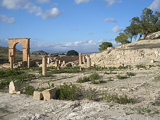
Pheradi Majius is a locality and archaeological site in Tunisia located at 36.250003°N 10.397047°E near the modern town of Sidi Khalifa in Sousse Governorate, Tunisia that is located at 36° 14′ 58″ N, 10° 23′ 57″E.

Sidi Khelifa is a Tunisian village located near the town of Bouficha on the Mediterranean coastal plain, about 100 kilometers south of Tunis.
Usta Murad Mosque, was a Tunisian mosque located in the medina of Tunis. It does not exist anymore.

Plane Island also known as Piana or Plana Island and—in Tunisian Arabic—as Jaziret el-Monbasta, is a flat, rocky island in the Mediterranean Sea roughly 3.75 kilometers (2.3 mi) off Cape Farina, Tunisia. It has a lighthouse.