
Ocracoke is a census-designated place (CDP) and unincorporated town located at the southern end of Ocracoke Island, located entirely within Hyde County, North Carolina, United States. The population was 948 as of the 2010 census. In the 2020 census, the population had dropped to 797 people.

Cape Hatteras is a cape located at a pronounced bend in Hatteras Island, one of the barrier islands of North Carolina.

Cape Hatteras Light is a lighthouse located on Hatteras Island in the Outer Banks in the town of Buxton, North Carolina and is part of the Cape Hatteras National Seashore. The lighthouse's semi-unique pattern makes it easy to recognize and famous. It is often ranked high on lists of most beautiful, and famous lighthouses in the US.

Hurricane Alex was one of the northernmost major hurricanes on record, and whose formation marked the fifth-latest start to an Atlantic hurricane season since 1954. The first named storm, hurricane, and major hurricane of the 2004 Atlantic hurricane season, Alex developed from the interaction between an upper-level low and a weak surface trough on July 31 to the east of Jacksonville, Florida. It moved northeastward, and strengthened to attain winds of 100 mph (160 km/h) before passing within 10 miles (16 km) of the Outer Banks coast. Alex strengthened further and reached a peak of 120 mph (190 km/h) winds while off the coast of New England, one of only six hurricanes to reach Category 3 status north of 38° N. Alex caused a scare of a hurricane-force direct hit in the Outer Banks of North Carolina, which had been devastated by Hurricane Isabel less than a year earlier.

Hatteras Island is a barrier island located off the North Carolina coast. Dividing the Atlantic Ocean and the Pamlico Sound, it runs parallel to the coast, forming a bend at Cape Hatteras. It is part of North Carolina's Outer Banks and includes the communities of Rodanthe, Waves, Salvo, Avon, Buxton, Frisco, and Hatteras. It contains the largest part of the Cape Hatteras National Seashore. Prior to European settlement the island was inhabited by Croatoan Native Americans.

Hatteras is an unincorporated village and census-designated place (CDP) in Dare County, North Carolina, United States, on the Outer Banks island of Hatteras, at its extreme southwestern tip. As of the 2010 census it had a population of 504. Immediately to the west of the village of Hatteras is Hatteras Inlet which separates Hatteras Island from the neighboring Ocracoke Island. North Carolina Highway 12 passes through the community linking it to Frisco to the east and Ocracoke to the west.

Herbert Covington Bonner was a Democratic U.S. Congressman from North Carolina between 1940 and 1965.

Cape Hatteras National Seashore is a United States national seashore which preserves the portion of the Outer Banks of North Carolina from Bodie Island to Ocracoke Island, stretching over 70 miles (110 km), and is managed by the National Park Service. Included within this section of barrier islands along N.C. 12, but outside the national seashore boundaries, are Pea Island National Wildlife Refuge and several communities, such as Rodanthe, Buxton, and Ocracoke. Cape Hatteras is a combination of natural and cultural resources, and provides a wide variety of recreational opportunities.

The Outer Banks are a 200 mi (320 km) string of barrier islands and spits off the coast of North Carolina and southeastern Virginia, on the east coast of the United States. They line most of the North Carolina coastline, separating Currituck Sound, Albemarle Sound, and Pamlico Sound from the Atlantic Ocean. A major tourist destination, the Outer Banks are known for their wide expanse of open beachfront and the Cape Hatteras National Seashore. The seashore and surrounding ecosystem are important biodiversity zones, including beach grasses and shrubland that help maintain the form of the land.

The PCL family of companies is a group of independent general contracting construction companies in Canada, the United States, Australia and the Caribbean. PCL has headquarters in Edmonton, Alberta, Canada, with the United States head office in Denver, Colorado.

Hurricane Emily in 1993 caused record flooding in the Outer Banks of North Carolina while remaining just offshore. The fifth named storm and the first yet strongest hurricane of the year's hurricane season, Emily developed from a tropical wave northeast of the Lesser Antilles on August 22, 1993. It moved northwestward and strengthened into a tropical storm on August 25, after becoming nearly stationary southeast of Bermuda. Emily then curved to the southwest but quickly resumed its northwest trajectory while strengthening into a hurricane. Late on August 31, the hurricane reached peak winds of 115 mph (185 km/h) on its approach to North Carolina. Although part of the eye passed over Hatteras Island in the Outer Banks, its absolute center remained 23 mi (37 km)/h) offshore. Gradually weakening, the hurricane swerved away from the coast toward the northeast and later east. Emily stalled again, this time northeast of Bermuda, and dissipated on September 6 to the southeast of Newfoundland.

North Carolina Highway 12 (NC 12) is a 148.0-mile-long (238.2 km) primary state highway in the U.S. state of North Carolina, linking the peninsulas and islands of the northern Outer Banks. Most sections of NC 12 are two lanes wide, and there are also two North Carolina Ferry System routes which maintain continuity of the route as it traverses the Outer Banks region. NC 12 is part of the Outer Banks Scenic Byway, a National Scenic Byway. The first NC 12 appeared on the 1924 North Carolina Official Map and at its greatest length ran from NC 30 in Pollocksville to NC 48 near Murfreesboro. Over time it was replaced by both U.S. Route 258 (US 258) and NC 58 and ceased to exist in 1958. The current NC 12 first appeared on the 1964 state highway map running from US 158 in Nags Head to Ocracoke. In 1976 NC 12 was extended to US 70 on the mainland and in 1987 was extended north to Corolla.
Oregon Inlet is an inlet along North Carolina's Outer Banks. It joins the Pamlico Sound with the Atlantic Ocean and separates Bodie Island from Pea Island, which are connected by the 2.8 mile Marc Basnight Bridge that spans the inlet. As one of the few access points to the ocean along this stretch of coast, Oregon Inlet is a major departure point for charter fishing trips, with a nearby harbor serving as the base for many large boats that travel miles out towards the Gulf Stream almost every day. The inlet is also the location of a U.S. Coast Guard motor lifeboat station.

Isabel Inlet was an informally named inlet along the Outer Banks of North Carolina. It was created by Hurricane Isabel when it swept ashore on September 18, 2003.
The North Carolina Department of Transportation Ferry Division is a branch of NCDOT that is responsible for the operation of over two dozen ferry services that transport passengers and vehicles to several islands along the Outer Banks of North Carolina.

The effects of Hurricane Isabel in North Carolina were widespread, with the heaviest damage in Dare County. The hurricane made landfall in the Outer Banks of North Carolina on September 18. There, storm surge flooding and strong winds damaged thousands of houses. The storm surge produced a 2,000 feet (610 m) wide inlet on Hatteras Island, isolating Hatteras by road for two months. Several locations along North Carolina Highway 12 were partially washed out or covered with debris. Hurricane Isabel produced hurricane-force wind gusts across eastern North Carolina, knocking down trees and power lines. About 700,000 residents lost power due to the storm, although most outages were restored within a few days. The hurricane killed three people in the state – two due to falling trees, and the other a utility worker attempting to restore electricity. Damage in the state totaled $450 million.
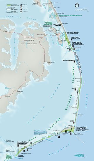
Hatteras Inlet is an estuary in North Carolina, located along the Outer Banks, separating Hatteras Island and Ocracoke Island. It connects the Atlantic Ocean to the Pamlico Sound. Hatteras Inlet is located entirely within Hyde County.

Ocracoke Inlet is an estuary located in the Outer Banks, North Carolina, United States that separates Ocracoke Island and Portsmouth Island. It connects the Atlantic Ocean to the Pamlico Sound. It is the southern terminus of the Cape Hatteras National Seashore, and the northern terminus of the Cape Lookout National Seashore. The inlet is approximately two miles across, although it changes daily.
Bodie Island is a long, narrow barrier peninsula that forms the northernmost portion of the Outer Banks. The land that is most commonly referred to as Bodie Island was at one time a true island, but in 1811 Roanoke Inlet, which had separated it from the Currituck Banks in the north, closed. As a result, the Currituck Banks and Bodie Island are now one contiguous peninsula, joined at the Nags Head area, where the inlet once flowed. Today, either name can be used to refer to peninsula as a whole, but both portions colloquially retain their historical names.

Hurricane Arthur was the earliest known hurricane to make landfall in the U.S. state of North Carolina during the calendar year. It was also the first hurricane to make landfall in the United States since Hurricane Isaac in 2012. The first named storm of the 2014 Atlantic hurricane season, Arthur developed from an initially non-tropical area of low-pressure over the Southeastern United States that emerged into the western Atlantic Ocean on June 28. After sufficiently organizing, developing a well-defined circulation and deep convection amid a favorable environment, it was classified as a tropical depression on July 1. The system continued to strengthen and was declared a tropical storm later that day. Drifting northward, the storm reached hurricane status early on July 3 and curved toward the north-northeast. Further structural organization resulted in additional intensification, and by 01:00 UTC on July 4, the system attained its peak winds of 100 mph (160 km/h) as a Category 2 hurricane on the Saffir–Simpson hurricane wind scale. Arthur made landfall at 03:15 UTC over North Carolina's Shackleford Banks, positioned between Cape Lookout and Beaufort, and intensified slightly further, with a minimum atmospheric pressure of 973 mbar. The storm then trekked swiftly northeast, weakening as it passed by Cape Cod and Nantucket, before transitioning into an extratropical cyclone and coming ashore at Weymouth, Nova Scotia, on July 5. The remnants continued generally northeastward through Atlantic Canada before ultimately dissipating on July 9 over the Labrador Sea.