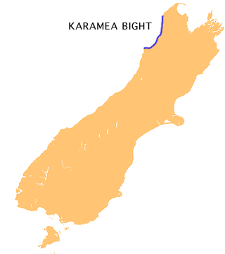
The Karamea Bight is the name given to a large bay in the Tasman Sea formed by a curved stretch of the West Coast of New Zealand's South Island. It stretches for 100 kilometres north from Cape Foulwind to just north of the mouth of the Heaphy River.

The Remutaka Range is the southernmost range of a mountain chain in the lower North Island of New Zealand. The chain continues north into the Tararua, then Ruahine Ranges, running parallel with the east coast between Wellington and East Cape.

Cape Palliser is a promontory on the southern coast of New Zealand's North Island and is the southernmost point of the North Island; it is in fact considerably farther south than Nelson or Blenheim in the South Island.

The Ruamahanga River runs through the southeastern North Island of New Zealand.
Ngawi is a small fishing / holiday village within five kilometres of Cape Palliser, the southern-most point of New Zealand's North Island.
Te Whiti, formerly Te Whiti o Tu in the nineteenth century, is a rural community in the Wairarapa region of New Zealand's North Island. Its status has been under dispute and threatened in the twentieth century, and Land Information New Zealand acknowledges Te Whiti solely as a homestead. Its full former name means "the place of crossing" in the Māori language, reflecting its location near a natural crossing of the Ruamahanga River where it is met by the Waingawa River. The Ruamahunga River runs north and west of the locality and is also met by the Tauweru River that flows across the south of Te Whiti. In relation to major Wairarapa centres, Te Whiti is south of Masterton and east of Carterton, while nearby communities include Te Whanga to the east and Gladstone and Longbush to the south. The Maungaraki Range is also nearby.
The Aorangi Range is a mountain range on the North Island of New Zealand. It is located in the Wairarapa region, extending more than 20 kilometres north from Cape Palliser, and is the southernmost mountain range on the island. The greater portion of these mountains are covered in native forest which is protected and set aside for public recreational use as part of the Aorangi Forest Park.
The Awhea River is a river of New Zealand. It is in the Wairarapa, close to the North Island's southernmost point, and flows south for 24 kilometres (15 mi) from rough hill country south of Martinborough to reach the Pacific 20 kilometres (12 mi) to the east of Cape Palliser.
The Eastern Hutt River is a river of New Zealand. It flows southwest from the Tararua Range to join with the Western Hutt River and become the Hutt River, a major river of the southern North Island.
The Huangarua River is a river of the southern North Island of New Zealand. Rising in the foothills of the Aorangi Range it flows north to join the Ruamahanga River to the north of Martinborough.
The Opouawe River is a river of the Wairarapa, in the Wellington Region of New Zealand's North Island. One of the North Island's southernmost rivers, it flows generally south to reach Cook Strait close to Te Kaukau Point, 12 kilometres (7 mi) northeast of Cape Palliser
The Oterei River is a river of the southern Wairarapa, in the Wellington Region of New Zealand's North Island. It flows initially northwest before turning south to reach Cook Strait 30 kilometres (19 mi) northeast of Cape Palliser.

The Pākuratahi River, previously the Pakuratahi River, is a river of the Wellington Region of New Zealand's North Island. It flows northwest from its source in the Remutaka Range 15 kilometres (9 mi) east of Lower Hutt to join the Te Awa Kairangi / Hutt River near Kaitoke.
The Rerewhakaaitu River is a river of the Wellington Region of New Zealand's North Island. It flows southeast from its sources in rough hill country southeast of Martinborough, reaching the Pacific Ocean 40 kilometres (25 mi) northeast of Cape Palliser.

The Tauwharenīkau River, formerly known as the Tauherenikau River, is a river of the Wellington Region of New Zealand's North Island. It flows initially southeast from its sources on the slopes of Mount Hector before turning southwest to run down a long valley in the Tararua Range. From the end of the valley it again turns southeast, flowing past the town of Featherston before reaching the northern shore of Lake Wairarapa.
The Wainuioru River is a river of the Wellington Region of New Zealand's North Island. A major tributary of the Pahaoa River, it follows a twisting generally southwestward course from its origins 25 kilometres east of Masterton, reaching the Pahaoa 20 kilometres (12 mi) southeast of Martinborough.

The Waiohine River is a river of the Greater Wellington Region of New Zealand's North Island.
The Whakatīkei River is a river of the Wellington Region of New Zealand's North Island. It flows generally southeast from its sources close to the west coast, 5 kilometres (3 mi) southeast of Paekākāriki, and reaches the Hutt River at Upper Hutt.
The Whawanui River is a river of the Wellington Region of New Zealand's North Island. It flows south from the Aorangi Range to reach Cook Strait 10 kilometres (6 mi) northeast of Cape Palliser. It is one of the southernmost rivers in the North Island.
The Tūranganui River of the Wellington Region of New Zealand flows through the south Wairarapa from its source in the Aorangi Range to reach the Ruamahanga River shortly before the latter's outflow into Palliser Bay.
