
Cape Agulhas is a rocky headland in Western Cape, South Africa. It is the geographic southern tip of Africa and the beginning of the traditional dividing line between the Atlantic and Indian Oceans according to the International Hydrographic Organization. It is approximately half a degree of latitude, or 55 kilometres (34 mi), further south than the Cape of Good Hope.

Mossel Bay is a harbour town of about 120,000 people on the Southern Cape of South Africa. It is an important tourism and farming region of the Western Cape Province. Mossel Bay lies 400 kilometres east of the country's seat of parliament, Cape Town, and 400 km west of Port Elizabeth, the largest city in the Eastern Cape. The older parts of the town occupy the north-facing side of the Cape St Blaize Peninsula, whilst the newer suburbs straddle the Peninsula and have spread eastwards along the sandy shore of the Bay.

Cape Point is a promontory at the southeast corner of the Cape Peninsula, a mountainous and scenic landform that runs north-south for about thirty kilometres at the extreme southwestern tip of the African continent in South Africa. Table Mountain and the city of Cape Town are close to the northern extremity of the same peninsula. The cape is located at 34°21′26″S18°29′51″E, about 2.3 kilometres (1.4 mi) east and a little north of the Cape of Good Hope on the southwest corner. Although these two rocky capes are very well known, neither cape is actually the southernmost point of the mainland of Africa; that is Cape Agulhas, approximately 150 kilometres (93 mi) to the east-southeast.

Paternoster is one of the oldest fishing villages on the West Coast of South Africa. It is situated 15 km north-west of Vredenburg and 145 km north of Cape Town, at Cape Columbine between Saldanha Bay and St Helena Bay. The town covers an area of 194.8 hectare and has approximately 1883 inhabitants.

Cape Leeuwin is the most south-westerly mainland point of the Australian continent, in the state of Western Australia.

Cape San Blas is part of a peninsula in Gulf County, Florida, extending westward from the mainland of Florida, separating St. Joseph Bay to the north from the Gulf of Mexico to the south. It is fifty-nine miles southeast of Panama City. The St. Joseph Peninsula extends northward from the west end of Cape San Blas. It is approximately 10 miles (16 km) south-southwest of the town of Port St. Joe, located at coordinates 29°39′49″N85°21′20″W.
Cape St. Francis is a village in South Africa, situated on a headland in the Eastern Cape Province. It is popular for its clean beaches and as a surfing location.
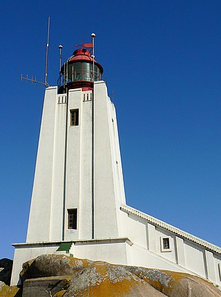
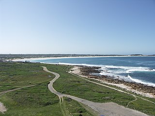
Cape Columbine is well known for its lighthouse, the last staffed lighthouse built on the South African coast.. The Cape Columbine Lighthouse was commissioned on October 1, 1936. Both the headland and lighthouse derive their name from the barque Columbine, that was wrecked 1.5 km North of the lighthouse on March 31, 1829.

Cape Anguille is a headland and the westernmost point in Newfoundland, reaching into the Gulf of Saint Lawrence. It is the southern edge of St. George's Bay. Its name is derived from the French word anguille, which means eel. Close to the cape is the community of Cape Anguille.

Seal Point is a lighthouse on Cape St. Francis in the Eastern Cape of South Africa. The lighthouse is operational and houses a museum. Public access to the top of the tower is allowed in the company of a guide.

The headland of Cape St. Francis is the outer extremity marking the boundary of Conception Bay on the Avalon Peninsula of the island of Newfoundland in the Canadian province of Newfoundland and Labrador. The International Maritime Organization also designates Cape St. Francis as the southern extremity of the Labrador Sea.
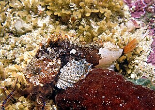
The smoothskin scorpionfish is a species of ray-finned fish, a waspfish belonging to the subfamily Tetraroginae of the family Scorpaenidae, the scorpionfishes and their relatives. It is the only species in the monotypic genus Coccotropsis. This species is endemic to the seas off South Africa.
The Green Point Lighthouse, Cape Town is an operational lighthouse on the South African coast. First lit on 12 April 1824, it is located on Mouille Point. The lighthouse was the first solid lighthouse structure on the South African coast and the oldest operational lighthouse in South Africa. The lighthouse was commissioned by acting Governor of the Cape Colony Sir Rufane Shaw Donkin and designed by German architect Herman Shutte. Building commenced in 1821 and was completed in 1823. The lighthouse started operating in 1824. The lighthouse cost approximately £6,420 pounds sterling to build. When the lighthouse was first lit, it burned Argand lamps fueled by sperm whale oil. The light from these lanterns could be seen for 6 nautical miles. The lighthouse was expanded to its present height in 1865. In 1922, the range of the light house was extended to 22 nautical miles when 3rd order dioptric flashing lights were installed. Its present characteristic is a white light flashing every 10 seconds. In 1926, a foghorn was installed in the lighthouse despite a letter of complaint sent to the Mayor of Cape Town in 1923 by Green Point residents. Local Residents call the Green Point Lighthouse "Moaning Minnie".
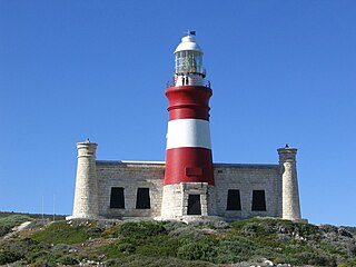
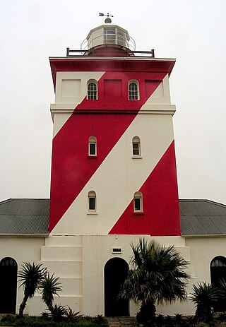
The Cape Agulhas Lighthouse is at Cape Agulhas, the southernmost tip of Africa. At 171 years old, it is the third-built lighthouse in South Africa, and the second-oldest still operating, after Green Point. It is located on the southern edge of the village of L'Agulhas, in the Agulhas National Park; the light is operated by Transnet National Ports Authority. In 2016, the American Society of Civil Engineers (ASCE) identified the lighthouse as a deserving prominent historic engineering project and International Historic Civil Engineering Landmark.
Mbhashe River is one of the major rivers in the Eastern Cape Province, South Africa. It flows in a southeastern direction and has a catchment area of 6,030 km2. The river drains into the Indian Ocean through an estuary located near the lighthouse at Bashee, south of Mhlanganisweni.

St Francis Bay is a holiday town in Sarah Baartman District Municipality in the Eastern Cape province of South Africa, roughly one hour’s drive from Gqeberha.
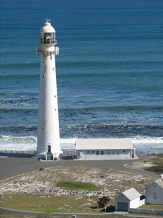
Slangkop Lighthouse is a lighthouse near the town of Kommetjie, near Cape Town, South Africa.

Cape Jervis Lighthouse is a lighthouse located at the headland of Cape Jervis on the most westerly part of the Fleurieu Peninsula on the east coast of Gulf St Vincent in South Australia.


