
NASA's Mars Exploration Rover (MER) mission was a robotic space mission involving two Mars rovers, Spirit and Opportunity, exploring the planet Mars. It began in 2003 with the launch of the two rovers to explore the Martian surface and geology; both landed on Mars at separate locations in January 2004. Both rovers far outlived their planned missions of 90 Martian solar days: MER-A Spirit was active until March 22, 2010, while MER-B Opportunity was active until June 10, 2018.
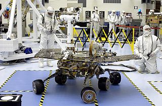
Spirit, also known as MER-A or MER-2, is a Mars robotic rover, active from 2004 to 2010. Spirit was operational on Mars for 2208 sols or 3.3 Martian years. It was one of two rovers of NASA's Mars Exploration Rover Mission managed by the Jet Propulsion Laboratory (JPL). Spirit landed successfully within the impact crater Gusev on Mars at 04:35 Ground UTC on January 4, 2004, three weeks before its twin, Opportunity (MER-B), which landed on the other side of the planet. Its name was chosen through a NASA-sponsored student essay competition. The rover got stuck in a "sand trap" in late 2009 at an angle that hampered recharging of its batteries; its last communication with Earth was on March 22, 2010.
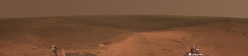
Opportunity, also known as MER-B or MER-1, and nicknamed Oppy, is a robotic rover that was active on Mars from 2004 until mid-2018. Opportunity was operational on Mars for 5110 sols. Launched on July 7, 2003, as part of NASA's Mars Exploration Rover program, it landed in Meridiani Planum on January 25, 2004, three weeks after its twin Spirit (MER-A) touched down on the other side of the planet. With a planned 90-sol duration of activity, Spirit functioned until it got stuck in 2009 and ceased communications in 2010, while Opportunity was able to stay operational for 5111 sols after landing, maintaining its power and key systems through continual recharging of its batteries using solar power, and hibernating during events such as dust storms to save power. This careful operation allowed Opportunity to operate for 57 times its designed lifespan, exceeding the initial plan by 14 years, 46 days. By June 10, 2018, when it last contacted NASA, the rover had traveled a distance of 45.16 kilometers.

A Mars rover is a motor vehicle designed to travel on the surface of Mars. Rovers have several advantages over stationary landers: they examine more territory, they can be directed to interesting features, they can place themselves in sunny positions to weather winter months, and they can advance the knowledge of how to perform very remote robotic vehicle control. They serve a different purpose than orbital spacecraft like Mars Reconnaissance Orbiter. A more recent development is the Mars helicopter.
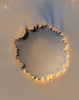
Victoria is an impact crater on Mars located at 2.05°S, 5.50°W in the Meridiani Planum extraterrestrial plain, lying situated within the Margaritifer Sinus quadrangle (MC-19) region of the planet Mars. This crater was first visited by the Mars Exploration Rover Opportunity. It is roughly 800 metres (2,600 ft) wide, nearly eight times the size of the crater Endurance, visited by Opportunity from sols 951 to 1630. It is informally named after Victoria – one of the five Spanish ships of Ferdinand Magellan and the first ship to circumnavigate the globe – and formally named after Victoria, Seychelles. Along the edges of the crater are many outcrops within recessed alcoves and promontories, named for bays and capes that Magellan discovered.

The Amazonis quadrangle is one of a series of 30 quadrangle maps of Mars used by the United States Geological Survey (USGS) Astrogeology Research Program. The Amazonis quadrangle is also referred to as MC-8.

The Lunae Palus quadrangle is one of a series of 30 quadrangle maps of Mars used by the United States Geological Survey (USGS) Astrogeology Research Program. The quadrangle is also referred to as MC-10. Lunae Planum and parts of Xanthe Terra and Chryse Planitia are found in the Lunae Palus quadrangle. The Lunae Palus quadrangle contains many ancient river valleys.
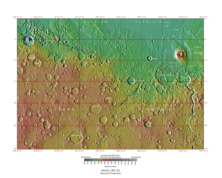
The Aeolis quadrangle is one of a series of 30 quadrangle maps of Mars used by the United States Geological Survey (USGS) Astrogeology Research Program. The Aeolis quadrangle is also referred to as MC-23 . The Aeolis quadrangle covers 180° to 225° W and 0° to 30° south on Mars, and contains parts of the regions Elysium Planitia and Terra Cimmeria. A small part of the Medusae Fossae Formation lies in this quadrangle.

The Margaritifer Sinus quadrangle is one of a series of 30 quadrangle maps of Mars used by the United States Geological Survey (USGS) Astrogeology Research Program. The Margaritifer Sinus quadrangle is also referred to as MC-19. The Margaritifer Sinus quadrangle covers the area from 0° to 45° west longitude and 0° to 30° south latitude on Mars. Margaritifer Sinus quadrangle contains Margaritifer Terra and parts of Xanthe Terra, Noachis Terra, Arabia Terra, and Meridiani Planum.

Endeavour is an impact crater located in the Meridiani Planum extraterrestrial plain within the Margaritifer Sinus quadrangle (MC-19) region of the planet Mars. Endeavour is about 22 kilometers (14 mi) in diameter. Using Mars Reconnaissance Orbiter data, phyllosilicate-bearing outcrops have been detected along its rim. These minerals may have formed under wet conditions in a low-acidic environment during the early history of Mars. There are raised rim segments to the north, east, and southwest. The rim has become worn, rounded and degraded, with infilling of plains material in a manner similar to the Victoria crater.

A cleaning event is a phenomenon whereby dust is removed from solar panels, in the context of exploration and science rovers on Mars, supposedly by the action of wind. The term cleaning event is used on several NASA webpages; generally supposing that Martian winds have blown dust clear off the probes on Mars, including the solar panels which power them, increasing their energy output. The nature of the cleaning events is not known, but the assumption is that wind blows the dust off the panels. Cleaning events were discovered in 2004 when several times power levels increased by 5% overnight, in contrast to the expectation they would decrease—the added power allowed the missions to continue beyond their expected lifetime. One theory is that wind currents in craters aid in cleaning events, and also if the rover is sloped, this is speculated to help remove dust.
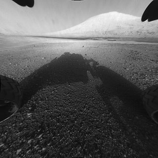
Mount Sharp, officially Aeolis Mons, is a mountain on Mars. It forms the central peak within Gale crater and is located around 5.08°S 137.85°E, rising 5.5 km (18,000 ft) high from the valley floor. Its ID in the United States Geological Survey's Gazetteer of Planetary Nomenclature is 15000.
Matijevic Hill, named after American NASA engineer Jacob "Jake" Matijevic, is a hill located on "Cape York", itself on the western rim of Endeavour Crater lying within the Margaritifer Sinus quadrangle (MC-19) region of the planet Mars. It was discovered by the Opportunity rover, and named by NASA on September 28, 2012. The "approximate" site coordinates are: 2.22923°S 5.35068°W.

Solander Point is at the north end of the west-southwestern ridgeline of Endeavour crater on the planet Mars. It is named after the Swedish scientist Daniel Solander, who was the first university-educated scientist to set foot on Australian soil at Botany Bay in 1770.

Opportunity is a robotic rover that was active on the planet Mars from 2004 to 2018. Launched on July 7, 2003, Opportunity landed on Mars' Meridiani Planum on January 25, 2004 at 05:05 Ground UTC, three weeks after its twin Spirit (MER-A), also part of NASA's Mars Exploration Rover Mission, touched down on the other side of the planet. While Spirit became immobile in 2009 and ceased communications in 2010, Opportunity exceeded its planned 90 sol duration of activity by 18 years, 13 days. Opportunity continued to move, gather scientific observations, and report back to Earth until 2018. What follows is a summary of events during its continuing mission.

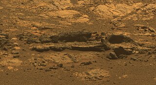
Bopolu is an impact crater located within the Meridiani Planum extraterrestrial plain of Mars. Bopulu was seen by Opportunity rover in 2010 in the distance, and with some of its rim visible. Bopoplu was officially named in 2006 along with 31 Mars craters. Research has indicated that the impact that is thought to have created Bopulu went so deep that it went through existing layers and ejected older material from Mars' Noachian period. Bopulu is a 19 kilometres (12 mi) diameter wide crater south of the Opportunity MER-B landing site, a rover which operated in the region starting in 2004 and therefore resulted in greater exploration and study of craters in this region. Bopulu was identified as a possible source for the Bounce Rock ejecta fragment Bounce rock, which was examined by the MER-B rover, was found to be similar in composition to the shergottite class of Mars meteorite found on Earth.

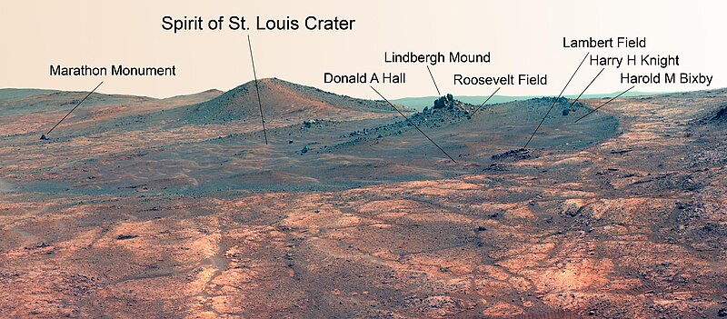
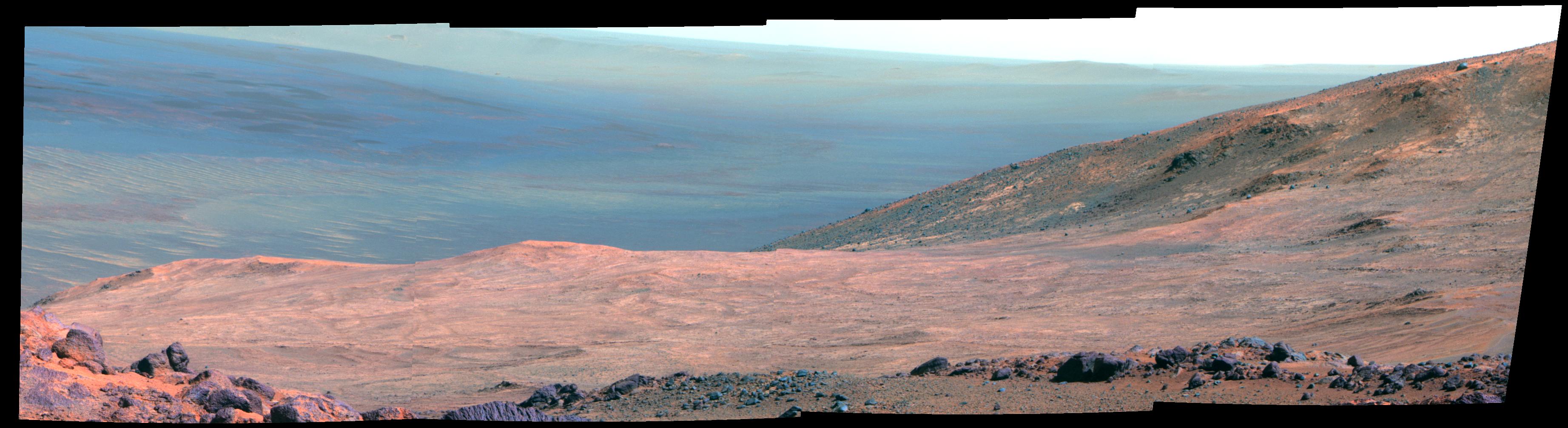
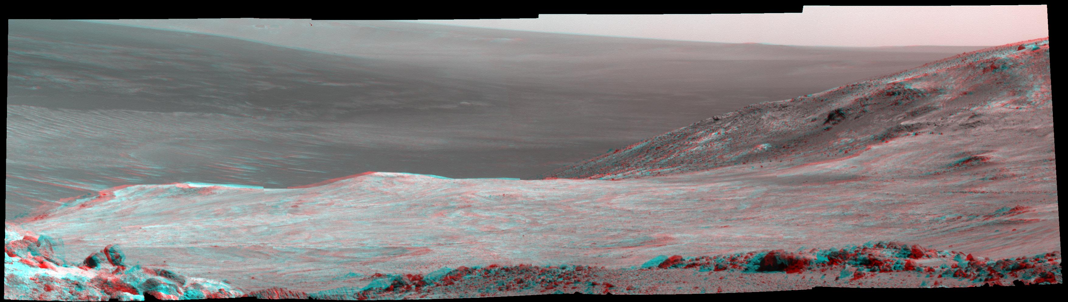
Cape York is a location on Mars, on the western rim of Endeavour crater. The Opportunity rover spent about two years exploring this portion of the rim in the early 2010s before moving south. The CRISM instrument on the Mars Reconnaissance Orbiter identified clay smectites in an area of Cape York, and the rover was sent to explore this location. MER-B Opportunity spend its fifth Martian Winter at Greeley Haven at Cape York, and also took a panorama at that location. MER-B spent 19 weeks stationed at Greeley Haven surviving the winter and went on the move again in May 2012, to further explore Cape York.

Farim is the name of an impact crater on the planet Mars, located inside a chain of unnamed craters bordering the northern rim of the larger Kepler crater. The crater's name, approved by the International Astronomical Union (IAU) on 11 March 2013, is derived from the town of Farim in Guinea-Bissau. Farim crater was described as a feature on Mars as early as 1971 in that year's edition of the Times Atlas of the World, and recently became of interest to scientists working on the 2001 Mars Odyssey mission, after the spacecraft's THEMIS camera made two surveys of Farim in December 2016.
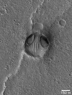
The Chryse Alien refers to a Martian crater in the Chryse Planitia, with a perceived resemblance to an "alien head".


