
Carmarthen is the county town of Carmarthenshire and a community in Wales, lying on the River Towy 8 miles (13 km) north of its estuary in Carmarthen Bay. The population was 14,185 in 2011, down from 15,854 in 2001, but gauged at 16,285 in 2019. It has a claim to be the oldest town in Wales – Old Carmarthen and New Carmarthen became one borough in 1546. It was the most populous borough in Wales in the 16th–18th centuries, described by William Camden as "chief citie of the country". Growth stagnated by the mid-19th century as new settlements developed in the South Wales Coalfield.

Llwynhendy, is a village and ward near the town of Llanelli in Carmarthenshire, Wales. The ward, which includes the village, as well as Cefncaeau, parts of Cwmcarnhywel and parts of Bryn and Penceilogi, had a population of 4,276.

The Tryweryn flooding or Tryweryn drowning, refers to the flooding of the rural community of Capel Celyn to the north west of Bala in Gwynedd, Wales, in the Afon Tryweryn valley. The village and other parts of the valley were flooded in 1965 to create Llyn Celyn reservoir, in order to supply Liverpool and Wirral with water for industry.

Bryncoch is a village near Neath in Neath Port Talbot County Borough, Wales. The name derives from the Welsh 'red hill', originally the name of a nearby farm.

Gwaun-Cae-Gurwen is a village and community in the borough of Neath Port Talbot, South West Wales. Historically a part of Glamorgan, Gwaun-Cae-Gurwen is a parish made up of the electoral wards of Gwaun-Cae-Gurwen and Lower Brynamman.

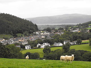
Llangain is a village and community in Carmarthenshire, in the south-west of Wales. Located to the west of the River Towy, and south of the town of Carmarthen, the community contains three standing stones, and two chambered tombs as well as the ruins of 15th century great house, Castell Moel. In 2001 the community's population was recorded at 574, decreasing slightly to 573 at the 2011 census.
Tycroes is a village in Carmarthenshire, Wales. As measured in the 2011 Census, the population of Tycroes electoral ward was 2,438 persons.
Fforestfach is a suburban district of Swansea, Wales which developed during the Victorian era as part of the expansion of Swansea, and to service several collieries in the area. It lies within the Cockett ward, between the districts of Waunarlwydd and Cwmbwrla, and contains the areas of Cadle and Ravenhill.

Llangunnor is a village and community located in Carmarthenshire, Wales. It is the southern suburb of Carmarthen town and consists mainly of typical suburban housing which has expanded in recent years. It has a small shop, two chapels, a church and a Primary School. It is made up of the villages and hamlets of Nantycaws, Pensarn, Login and Pibwrlwyd.
Tal-y-bont is a village in Ceredigion, Wales, located on the A487 road about halfway between Aberystwyth and Machynlleth. At the 2011 census the population was 662 with 63% born in Wales. Tal-y-bont is in the community of Ceulanamaesmawr.

Pen-y-garn is a small village in the Tirymynach district of Ceredigion, Wales, approximately 4 miles (6 km) north-east of Aberystwyth. Along with the hamlet of Rhydypennau, Pen-y-garn is now often considered to be part of the neighbouring larger village of Bow Street. All three places stretch in a long narrow strip along the main Aberystwyth to Machynlleth road (A487). As well as the houses on the main road from Cross Street up to Ysgol Rhydypennau, Pen-y-garn also includes the housing estates of Maes Ceiro, Bryn Meillion, Maes y Garn and Cae'r Odyn.

Llywel is a small village located on the A40, about 4 miles (6.4 km) west of Sennybridge in Brecknockshire, Wales. The Afon Gwydderig runs through the village, not far from its source. Llywel also gives its name to a community. The main settlement in the community is Trecastle. According to the 2001 Census the population of Llywel community is 524, falling to 497 at the 2011 Census.

Coelbren is a small rural village within the community of Tawe Uchaf in southernmost Powys, Wales. It lies on the very northern edge of the South Wales Coalfield some six miles north-east of Ystradgynlais and just outside the southern boundary of the Brecon Beacons National Park. It is known for Henrhyd Falls, a 27m high waterfall which serves as a National Trust-managed visitor attraction on the Nant Llech. To the east of the village flows the Afon Pyrddin which plunges over two more spectacular falls.
Ffairfach is a village one-half mile (0.80 km) south of the market town of Llandeilo in the eastern part of Carmarthenshire, Wales. It is close to the confluence of the Afon Cennen and the River Towy. Population is 516 according to 2017 census.

The University of Wales Trinity Saint David is a multi-campus university with three main campuses in South West Wales, in Carmarthen, Lampeter and Swansea, a fourth campus in London, England, and learning centres in Cardiff, Wales, and Birmingham, England.

Gwynfe or Capel Gwynfe is a small village inside the portion of Brecon Beacons National Park that is in Carmarthenshire, a county of southwestern Wales. This village is situated between Trichrug and the western slopes of the Black Mountain, to the west of the A4069 road about halfway between Llangadog and Brynamman. The village comprises a scattered collection of mostly nineteenth and twentieth-century housing that developed around several chapels. The area around the village is mainly farmland and the village was 2004 'Village of the Year for Carmarthenshire'. The village has a grade-two listed phone box now used as an information centre and a modern community hall built in 2001. The community association have erected 2 large woodcarvings of three red kites.

Capel Heol Awst is an Independent Welsh chapel in the town of Carmarthen, Carmarthenshire, Wales. The present building dates from 1826 to 1827, replacing a 1726 building which itself had been enlarged in 1802 and again in 1826 to seat a congregation of 1000. It is located at 7 Friars Park, Carmarthen. It was designated as a Grade II* listed building on 19 May 1981.

Capel Heol Dŵr was a Calvinistic Methodist chapel in the town of Carmarthen, Carmarthenshire, Wales. The building dates from 1831 and is located at Water St, Carmarthen. It was designated as a Grade II listed building on 19 May 1981.
Carmarthen Cemetery Chapel is a cemetery chapel in the town of Carmarthen, Carmarthenshire, Wales. The building dates from 1855 and is located at 6, Russell Terrace, Carmarthen.

The Shah Jalal Mosque, officially the Shah Jalal Mosque & Islamic Cultural Centre is a listed place of worship in Cardiff, Wales. Originally built for Methodist Christians, it ceased as a church in the 1980s and is now a mosque. It is affiliated to Bangladeshi Sufi Fultoli movement.
