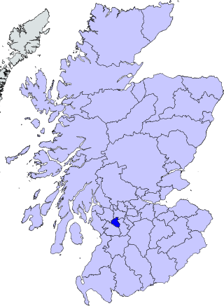
East Renfrewshire is one of 32 council areas of Scotland. It was formed in 1996, as a successor to the Eastwood district of the Strathclyde region. The northeastern part of the council area is close to Glasgow and many of the council area's northern settlements fall into the Greater Glasgow urban area.

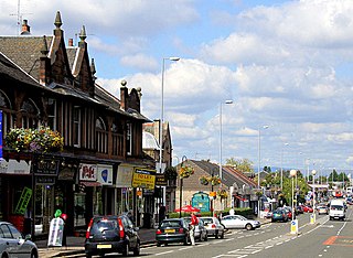
Barrhead is a town in East Renfrewshire, Scotland, thirteen kilometres (8 mi) southwest of Glasgow city centre on the edge of the Gleniffer Braes. At the 2011 census its population was 17,268.

Newton Mearns is a suburban town and the largest settlement in East Renfrewshire, Scotland. It lies 7 miles (11 km) southwest of Glasgow City Centre on the main road to Ayrshire, 410 feet (125 m) above sea level. It has a population of approximately 26,993, stretching from Whitecraigs and Kirkhill in the northeast to Maidenhill in the southeast, to Westacres and Greenlaw in the west and Capelrig/Patterton in the northwest.
Giffnock is a town and the administrative centre of East Renfrewshire in the Central Lowlands of Scotland.

Netherlee is a suburban residential area in East Renfrewshire, Scotland. It is situated on the west bank of the White Cart Water about 4 miles (6.5 km) south of Glasgow city centre. Part of the Greater Glasgow conurbation, it is mostly contiguous with the city, and is just beyond the boundary of its local authority area. It is a separate census locality from Glasgow, like other areas such as neighbouring Giffnock and Clarkston. Netherlee is directly contiguous with Stamperland. It is also in a council ward with Clarkston and its neighbour Busby. As of 2012, Netherlee has a population of 4,550.
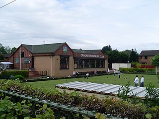
Crookston is a residential suburb on the southwestern edge of the city of Glasgow, Scotland.
Eaglesham is a village in East Renfrewshire, Scotland, situated about 10 miles (16 km) south of Glasgow, 3 miles (5 km) southeast of Newton Mearns and south of Clarkston, and 4 miles (6.4 km) southwest of East Kilbride.

East Renfrewshire is a constituency of the House of Commons, to the south of Glasgow, Scotland. It elects one Member of Parliament (MP) using the first-past-the-post system of voting.

Muirend is an area on the South side of Glasgow, Scotland. It is situated about 4 miles (6.5 km) south of Glasgow city centre. Muirend became extensively urbanised in the 20th century, developing into a commuter suburb. In a 2014 Royal Mail survey, the G44 postcode – which includes Muirend – was rated as the most desirable area of Scotland to live in. Neighbouring areas include Cathcart, Merrylee and Newlands in Glasgow, and Netherlee and Giffnock in East Renfrewshire. Some buildings that are locally associated with Muirend, including the main row of shops, as well as Hazelden Park and Muirend Pavilion, are located in East Renfrewshire. Notable residents include Sam McAulay amongst others.

Eastwood is a constituency of the Scottish Parliament (Holyrood) covering part of the council area of East Renfrewshire. It elects one Member of the Scottish Parliament (MSP) by the first past the post method of election. It is also one of ten constituencies in the West Scotland electoral region, which elects seven additional members, in addition to the ten constituency MSPs, to produce a form of proportional representation for the region as a whole.

Neilston is a village and parish in East Renfrewshire in the west central Lowlands of Scotland. It is in the Levern Valley, two miles southwest of Barrhead, 3+3⁄4 miles south of Paisley, and 5+3⁄4 miles south-southwest of Renfrew, at the southwestern fringe of the Greater Glasgow conurbation. Neilston is a dormitory village with a resident population of just over 5,000 people.

Renfrewshire or the County of Renfrew is a historic county, registration county and lieutenancy area in the west central Lowlands of Scotland. The lieutenancy area covers the three modern council areas of Inverclyde, Renfrewshire and East Renfrewshire, and this area is occasionally termed Greater Renfrewshire to distinguish it from the modern council area called Renfrewshire. The historic county additionally included territory on the south-western edge of Glasgow which was gradually transferred to the administrative area of the city as it grew.
Perceton is a medieval settlement and old country estate in North Ayrshire, Scotland, near the town of Irvine. The ruined church in Perceton is one of the oldest buildings in the Irvine district. The earliest legible gravestone dates from 1698, though older stone coffins will certainly still rest deep within the small hillock on which the chapel and graveyard sit.

Deaconsbank is a neighbourhood in the Scottish city of Glasgow. It is situated south of the River Clyde. The main feature of the area, which falls into the Greater Pollok ward of Glasgow City Council and directly borders the East Renfrewshire council region, is an estate of around 639 private houses built in the late 1970s by Barratt Developments, prior to which the area was open farmland. Deaconsbank is bordered by the M77 motorway to the west and by Rouken Glen Park and golf course to the east. The northern parts of the suburban town of Newton Mearns are a short distance to the south, as is Patterton railway station.
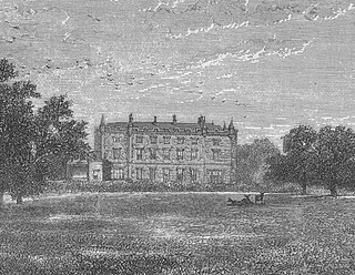
Caldwell is a mansion and old estate with the remains of a castle nearby. These lands lie close to the Lugton Water and the villages of Uplawmoor in East Renfrewshire and Lugton in East Ayrshire.

Clarkston is a suburban town in East Renfrewshire, in the Central Lowlands of Scotland. A dormitory town with a population of around 10,000, Clarkston is on the southern fringe of the Greater Glasgow conurbation and directly adjoins the neighbouring suburban villages of Busby and Netherlee, as well as the towns of Newton Mearns and Giffnock.

Eastwood is a residential neighbourhood in the city of Glasgow, Scotland. It is situated south of the River Clyde, and is part of the Newlands/Auldburn ward under Glasgow City Council.
Millhall is a hamlet in East Renfrewshire, in the Central Lowlands of Scotland. It lies 0.8 miles (1.3 km) southeast of Eaglesham, 8.3 miles (13.4 km) northwest of Strathaven and 3.6 miles (5.8 km) southwest of East Kilbride.