Capt. John Jeffries Burial Marker

Last updated
Jeffries, Capt. John, Burial Marker
Capt. John Jeffries Burial Marker-01.jpg
Captain John Jeffries monument in the Scullville Bible Church cemetery September 5, 2012
Location map of Atlantic County, New Jersey.svg
Red pog.svg
LocationScullville Bible Church Cemetery, 1546 Somers Point Road, Egg Harbor Township, NJ 08234
Coordinates 39°20′55.88″N74°39′39.12″W / 39.3488556°N 74.6608667°W / 39.3488556; -74.6608667
Built1887
NRHP reference No. 84002511 [1]
NJRHP No.414 [2]
Significant dates
Added to NRHPJune 14, 1984
Designated NJRHPMay 1, 1984

Capt. John Jeffries Burial Marker is a historic burial monument in the cemetery at Scullville Bible Church in Egg Harbor Township, New Jersey, along County Route 559 near Somers Point. It was built in 1887 and added to both the New Jersey Register of Historic Places and the National Register of Historic Places in 1984.

Contents

Capt. Jeffries (1829-1887) is known for his association with the ship Twenty One Friends, which, following an incident at sea, floated without crew across the Atlantic Ocean for two years before being claimed and returned to service.

The Monument

Inscription on Capt. John Jeffries Burial Marker featuring the schooner "Twenty One Friends". Capt. John Jeffries Burial Marker-03.jpg
Inscription on Capt. John Jeffries Burial Marker featuring the schooner “Twenty One Friends”.

The Capt. John Jeffries burial marker is approximately 15 feet (4.6 m) tall and the largest marker in the Scullville Bible Church cemetery. The church was built in 1866 and, at the time of his death, was named Palestine Bible Protestant Church. The monument is made of marble and stands on a square brick base approximately 4 feet (1.2 m) on each side. It is located in the Jeffries family plot behind the church, surrounded by other local-area family plots, many of which also date back to the 19th century. The square center section features an inscription, and above that a bas-relief engraving of the ship associated with Jeffries—and the source of his historical fame—the Twenty One Friends. [3] Another smaller section above bears the initials “J.J.” and a draped urn is carved at the top of the monument. The center inscription reads: Capt. John Jeffries. Born Nov. 15, 1829. Died March 17th 1887. A member of the K. of P.

The Jeffries of Great Egg Harbor

The Jeffries family can trace its genealogy back to 18th-century European settlers of Rhode Island. [4] John Jeffries Sr. (1735-1810) from Egg Harbor earned a pension for his service during the American Revolutionary War. [5] [6] The family owned land where Patcong Creek empties into Great Egg Harbor River, and it was here they built a two-storey plantation house. [7] The area became known as Jeffries Landing and was an active port as well as later becoming a popular destination area for bathers. [7]

The settlement that formed inland, north of Jeffries Landing, came to be called Jeffers, also named after the family. [8] In the early 1900s, Jeffers was renamed Scullville, honoring a different family, the Sculls. [9] Currently, where Patcong Creek meets Great Egg Harbor River is still called Jeffries Landing.

John Sr. and his wife, Judiah, had three sons, one of whom was John Jeffries Jr. (1789-1834). [4] [7] In 1819 John Jeffries Jr. was named wharf master at Jeffries Landing, responsible for collecting the wharfage of 30 cents per day to dock there. [7] In 1829, John Jr.’s wife, Isabell, gave birth to John III (1829-1887), who would grow up to become a sea captain. [7] [9]

Capt. John Jeffries III later lived along English Creek, upstream from Jeffries Landing along the Great Egg Harbor River. [7] He was married to Hannah Barrett Jeffries. [4] [7]

Variations of the name

The family name can be seen spelled different ways; Jeffries, Jeffryes, Jeffrys and Jeffers appear with interchangeability although all reasonably refer to the same family. [10] Some evidence of this can be found within the penned family plot in Scullville (Palestine) Bible Church cemetery. On one side of the Captain, his wife Hannah “Jeffers” is buried and on the other side, his young son Samuel J. “Jeffers”. In between stands the monument to Capt. John “Jeffries”.

Shipbuilding along Great Egg Harbor River

The banks of Great Egg Harbor River, from Mays Landing to Somers Point, were an ideal environment for shipbuilding in the century following the American Revolutionary War due to natural resources in the area. [11] These resources included lumber from pine, oak, and cedar as well as bog ore. [12] [13] The waterways were deep enough for ships up to 2000 tons (1,800 MT). [11] [13] Sawmills and blast furnaces were available in the area. [11] [12] [13] What was not used to build ships was exported in their holds. [11] [12] [13] One shipwright during this time was Capt. Samuel Gaskill of Mays Landing. [11] [14]

The Twenty One Friends

In 1872, Capt. Gaskill built a three-masted (tern) schooner for Capt. Jeffries. [10] [14] The ship was financed by a group of 21 Philadelphia Quakers and consequently named the Twenty One Friends. [10] [15]

In 1885, returning to Philadelphia with a full load of lumber from Brunswick, Georgia, the Twenty One Friends was rammed by the John D. May off the coast of Cape Hatteras. Capt. Jeffries removed his crew and abandoned the vessel. The ship and cargo were left to the mercy of the sea. [3] [10] [15]

Capt. Jeffries’ concern for the safety of his men was appropriate; however, the Gaskill-made ship proved itself to be more seaworthy than expected. After the collision, the ghost ship was sighted on both sides of the Atlantic over the next two years. [3] [10] [15] It finally came ashore in Ireland, where its cargo was salvaged and it was employed as a fishing vessel. [10] [15] The Twenty One Friends remained in service until 1914. [10] [15]

Historical significance

The Jeffries monument represents not only the life of a sea captain from the Great Egg Harbor River, but also an industry along that river during the 19th century. [10] There are few remaining relics from the marine and shipbuilding industries that mark this region's history during that time. [10] [14] [15]

In addition, the monument has been singled out for its intricate carvings, which helped achieve its NRHP status. [3]

See also

Related Research Articles

<span class="mw-page-title-main">Atlantic County, New Jersey</span> County in New Jersey, United States

Atlantic County is a county located along the Jersey Shore in the U.S. state of New Jersey. As of the 2020 census, the county was the state's 15th-most-populous county, with a population of 274,534, a drop of 15 from the 2010 census count of 274,549. Its county seat is the Mays Landing section of Hamilton Township. The county is part of the Jersey Shore region of the state.

<span class="mw-page-title-main">New Jersey Route 50</span> State highway in southern, New Jersey, US

Route 50 is a state highway in the southern part of the U.S. state of New Jersey. It runs 26.02 mi (41.88 km) from an intersection with U.S. Route 9 and the Garden State Parkway in Upper Township, Cape May County, north to an intersection with US 30 and County Route 563 in Egg Harbor City, Atlantic County. The route, which is mostly a two-lane undivided road, passes through mostly rural areas of Atlantic and Cape May counties as well as the communities of Tuckahoe, Corbin City, Estell Manor, and Mays Landing. Route 50 intersects several roads, including Route 49 in Tuckahoe, US 40 in Mays Landing, and US 322 and the Atlantic City Expressway in Hamilton Township.

<span class="mw-page-title-main">Egg Harbor Township, New Jersey</span> Township in Atlantic County, New Jersey, United States

Egg Harbor Township is a township in Atlantic County, in the U.S. state of New Jersey. As of the 2020 United States census, the township's population was 47,842, its highest decennial count ever and an increase of 4,519 (+10.4%) from the 2010 census count of 43,323, which in turn reflected an increase of 12,597 (+41.0%) from the 30,726 counted in the 2000 census.

<span class="mw-page-title-main">Egg Harbor City, New Jersey</span> City in Atlantic County, New Jersey, United States

Egg Harbor City is a city in Atlantic County, in the U.S. state of New Jersey. The city, and all of Atlantic County, is part of the Atlantic City-Hammonton metropolitan statistical area, which in turn is included in the Philadelphia-Reading-Camden combined statistical area and the Delaware Valley. As of the 2020 United States census, the city's population was 4,396, an increase of 153 (+3.6%) from the 2010 census count of 4,243, which in turn reflected a decline of 302 (−6.6%) from the 4,545 counted in the 2000 census.

<span class="mw-page-title-main">Galloway Township, New Jersey</span> Township in Atlantic County, New Jersey, United States

Galloway Township is a township in Atlantic County, in the U.S. state of New Jersey, and a growing edge city to neighboring Atlantic City. At 114.49 square miles (296.5 km2) of total area of land and water, Galloway Township is the largest municipality in the state. As of the 2020 United States census, the township's population was 37,813, its highest decennial count ever and an increase of 464 (+1.2%) from the 2010 census count of 37,349, which in turn reflected an increase of 6,140 (+19.7%) from the 31,209 counted in the 2000 census.

<span class="mw-page-title-main">Hamilton Township, Atlantic County, New Jersey</span> Township in Atlantic County, New Jersey, United States

Hamilton Township is a township in Atlantic County, in the U.S. state of New Jersey. As of the 2020 United States census, the township's population was 27,484, an increase of 981 (+3.7%) from the 2010 census count of 26,503, which in turn reflected an increase of 6,004 (+29.3%) from the 20,499 counted in the 2000 census. The Township of Hamilton was incorporated by the New Jersey Legislature on February 5, 1813.

<span class="mw-page-title-main">Mays Landing, New Jersey</span> Populated place in Atlantic County, New Jersey, US

Mays Landing is an unincorporated community and census-designated place (CDP) located within Hamilton Township, Atlantic County, in the U.S. state of New Jersey. At the 2010 U.S. census, May's Landing's population was 2,135. It is the county seat of Atlantic County.

<span class="mw-page-title-main">Mullica Township, New Jersey</span> Township in Atlantic County, New Jersey, United States

Mullica Township is a township in Atlantic County, in the U.S. state of New Jersey. As of the 2020 United States census, the township's population was 5,816, a decrease of 331 (−5.4%) from the 2010 census count of 6,147, which in turn reflected an increase of 235 (+4.0%) from the 5,912 counted in the 2000 census. Geographically, the township, and all of Atlantic County, is part of the South Jersey region of the state and of the Atlantic City-Hammonton metropolitan statistical area, which in turn is included in the Philadelphia-Reading-Camden combined statistical area and the Delaware Valley.

<span class="mw-page-title-main">Little Egg Harbor Township, New Jersey</span> Township in Ocean County, New Jersey, US

Little Egg Harbor Township is a township situated on the Jersey Shore, within Ocean County, in the U.S. state of New Jersey. The township is the southernmost municipality in both Ocean County and the New York metropolitan area. As of the 2020 United States census, the township's population was 20,784, its highest decennial count ever and an increase of 719 (+3.6%) from the 2010 census count of 20,065, which in turn reflected an increase of 4,120 (+25.8%) from the 15,945 counted in the 2000 census.

<span class="mw-page-title-main">Port Republic, New Jersey</span> City in Atlantic County, New Jersey, United States

Port Republic is a city on the Mullica River, located in Atlantic County, in the U.S. state of New Jersey. As of the 2020 United States census, the city's population was 1,101, a decrease of 14 (−1.3%) from the 2010 census count of 1,115, which in turn reflected an increase of 78 (+7.5%) from the 1,037 counted in the 2000 census.

<span class="mw-page-title-main">Somers Point, New Jersey</span> City in Atlantic County, New Jersey, United States

Somers Point is a city situated on the Jersey Shore that is the oldest settlement in Atlantic County, in the U.S. state of New Jersey. It was settled by Europeans in 1693 and was incorporated as a borough in 1886. Somers Point was incorporated as a city in 1902. The city is located in eastern Atlantic County, southwest of Atlantic City, in the South Jersey region of the state.

<span class="mw-page-title-main">Bass River Township, New Jersey</span> Township in Burlington County, New Jersey, United States

Bass River Township is a township at the southeastern tip of Burlington County, in the U.S. state of New Jersey. The township bears a shoreline fronting both the Bass River and the Great Bay. As of the 2020 United States census, the township's population was 1,355, a decrease of 88 (−6.1%) from the 2010 census count of 1,443, which in turn had reflected a decline of 67 (−4.4%) from the 1,510 counted in the 2000 census. The township and all of Burlington County is a part of the Philadelphia-Reading-Camden combined statistical area and the Delaware Valley. Bass River is the only municipality in Burlington County traversed by the Garden State Parkway.

<span class="mw-page-title-main">Mullica River</span> River

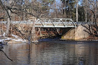
The Mullica River is a 50.6-mile-long (81.4 km) river in southern New Jersey in the United States. The Mullica was once known as the Little Egg Harbor River.

Eric Pålsson Mullica was an early Swedish settler to New Sweden. He and his family were the source of the name of several geographic features and places in New Jersey.

<span class="mw-page-title-main">Atlantic County Bikeway</span>

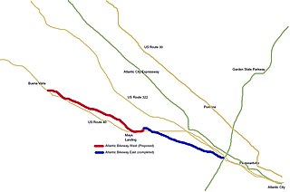
The Atlantic County Bikeway is a rail trail in Atlantic County, New Jersey.

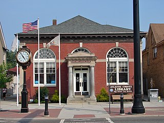
Atlantic County Library System is the county library system of Atlantic County, New Jersey. The library system is the information center in Atlantic County. The Library System includes ten branch libraries located throughout Atlantic County: Absecon, Brigantine, Egg Harbor City, Egg Harbor Township, Galloway Township, Hammonton, Mays Landing, Pleasantville, Somers Point, and Ventnor. The computerized public access catalog contains over 500,000 books, audio-visual and downloadable items. Atlantic County Library System also provides books-by-mail and other outreach services.

Weymouth was a schooner that carried coal on the Great Egg Harbor River. She was built in 1868 as a 60-ton, two-masted schooner by carpenter Samuel Gaskill at what is now Gaskill Park, Mays Landing, New Jersey. She was used to ship charcoal and other goods produced in the Pine Barrens along the Atlantic coast until the early 1890s, when she was left tied to a dock, as was common with retired merchant ships at the time. She came loose from her dock on the Great Egg Harbor River and ran aground on tidal mud flats about a mile downstream; her owners, lacking the money to move her, abandoned her.

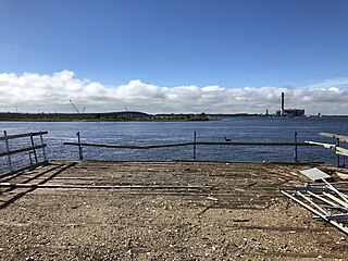
Great Egg Harbor Bay is a bay between Atlantic and Cape May counties along the southern New Jersey coast. The name derives from Dutch explorer Cornelius Jacobsen May's description of the plentiful birds laying eggs, naming the waters Eyren Haven, which translates to Egg Harbor in English. The bay has a total area of 8.5 sq mi (22 km2). Its depth ranges from shallow waters in the southern extension, called Peck Bay, to a 33 ft (10 m) deep channel.

<span class="mw-page-title-main">Green Bank, New Jersey</span> Place in Burlington County, New Jersey, United States

Green Bank is an unincorporated community located within Washington Township, in Burlington County, New Jersey, United States. It is located on the Mullica River.

<span class="mw-page-title-main">Seaview Harbor, New Jersey</span> Populated place in Atlantic County, New Jersey, US

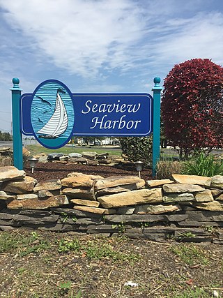
Seaview Harbor is a harbor and an unincorporated community located within Egg Harbor Township in Atlantic County, in the U.S. state of New Jersey.

References

  1. "National Register of Historic Places". Searchable database. NRHP. Archived from the original on August 3, 2012. Retrieved October 1, 2012.
  2. "New Jersey and National Registers of Historic Places - Atlantic County" (PDF). NJ DEP - Historic Preservation Office. June 4, 2012. p. 3. Archived from the original (PDF) on September 16, 2012. Retrieved October 1, 2012.
  3. 1 2 3 4 5 Gearren, Joan (1981). "Survey of Cultural Resources of the Historic Era in the Watersheds of the Great Egg Harbor and Tuckahoe Rivers". NJ Office of Cultural and Environmental Services, Historic Preservation Section (108–30). Retrieved October 2, 2012.
  4. 1 2 3 Bennett, J. H. (1964). The Jeffryes of Great Egg Harbor. cited in Nickles, Ann and J. H. Bennett (1964). Sketches of Egg Harbor Township: Scullville. Egg Harbor City, NJ: Laureate Press, Inc. Archived from the original on March 6, 2012. Retrieved October 1, 2012.
  5. "1840 Census of Pensioners and Revolutionary War Soldiers, Atlantic County, NJ" . Retrieved October 1, 2012.
  6. Sheridan, June (September 7, 2012). "Email RFI response from GEHTHS librarian". Greate Egg Harbour Township Historical Society Museum and Library.{{cite web}}: Missing or empty |url= (help)
  7. 1 2 3 4 5 6 7 Nickles, Ann and J. H. Bennett (1964). Sketches of Egg Harbor Township: Scullville. Egg Harbor City, NJ: Laureate Press, Inc. Archived from the original on March 6, 2012. Retrieved October 1, 2012.
  8. "USGS Topographical Map of NJ". U.S. Geological Survey. 1885. Retrieved October 1, 2012.
  9. 1 2 Martinelli, Patricia A. (2012). New Jersey Ghost Towns: Uncovering the Hidden Past. Stackpole Books. p. 66. ISBN   978-0811709101.
  10. 1 2 3 4 5 6 7 8 9 Ashton, Charles (May 21, 1982). "NRHP Nomination Form". Library of the Atlantic Heritage Center.
  11. 1 2 3 4 5 Crane, Richard Roberts (1964). Sketches of Egg Harbor Township: Shipbuilding Along the Great Egg Harbor River. Egg Harbor City, NJ: Laureate Press, Inc. Archived from the original on March 6, 2012. Retrieved October 1, 2012.
  12. 1 2 3 Nickles, Ann and Margaret Hart (1964). Sketches of Egg Harbor Township: English Creek. Egg Harbor City, NJ: Laureate Press, Inc. Archived from the original on September 3, 2012. Retrieved October 1, 2012.
  13. 1 2 3 4 Gordon, Thomas (1834). A Gazetteer of the State of New Jersey. Philadelphia: Daniel Fenton. pp. 95, 132, 135, 175, 263.
  14. 1 2 3 Gordinier, Glenn S. "Maritime Enterprise in New Jersey: Great Egg Harbor During the Nineteenth Century". New Jersey History. xcvii (2): 104–117.
  15. 1 2 3 4 5 6 "Museum exhibits". Atlantic Heritage Center Museum and Library.{{cite web}}: Missing or empty |url= (help)