The Netherlands Antilles was a constituent country of the Kingdom of the Netherlands. The country consisted of several island territories located in the Caribbean Sea. The islands were also informally known as the Dutch Antilles. The country came into being in 1954 as the autonomous successor of the Dutch colony of Curaçao and Dependencies and was dissolved in 2010. The Dutch colony of Surinam, although it was relatively close by on the continent of South America, did not become part of the Netherlands Antilles but became a separate autonomous country in 1954. All the island territories that belonged to the Netherlands Antilles remain part of the kingdom today, although the legal status of each differs. As a group they are still commonly called the Dutch Caribbean, regardless of their legal status. People from this former territory continue to be called Antilleans in the Netherlands.

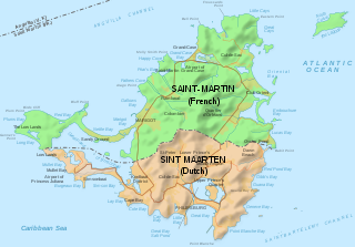
Saint Martin is an island in the northeast Caribbean Sea, approximately 300 km (190 mi) east of Puerto Rico. The 87 square kilometres (34 sq mi) island is divided roughly 60:40 between the French Republic and the Kingdom of the Netherlands, but the Dutch part is more populated than the French part. The division dates to 1648. The northern French part comprises the Collectivity of Saint Martin and is an overseas collectivity of the French Republic. As part of France, the French part of the island is also part of the European Union. The southern Dutch part comprises Sint Maarten and is one of four constituent countries that form the Kingdom of the Netherlands.

The Antilles is an archipelago bordered by the Caribbean Sea to the south and west, the Gulf of Mexico to the northwest, and the Atlantic Ocean to the north and east.
The Leeward Islands are a group of islands situated where the northeastern Caribbean Sea meets the western Atlantic Ocean. Starting with the Virgin Islands east of Puerto Rico, they extend southeast to Guadeloupe and its dependencies. In English, the term Leeward Islands refers to the northern islands of the Lesser Antilles chain. The more southerly part of this chain, starting with Dominica, is called the Windward Islands. Dominica was originally considered a part of the Leeward Islands, but was transferred from the British Leeward Islands to the British Windward Islands in 1940.

Sint Eustatius, also known locally as Statia, is an island in the Caribbean. It is a special municipality of the Netherlands.

Air Sunshine is an airline based in the United States and in Puerto Rico. It operates scheduled service to and from San Juan and Vieques, Puerto Rico, St. Lucia, Anguilla, Dominica, Sint Maarten, Nevis, St. Kitts, Tortola and Virgin Gorda in the British Virgin Islands and Saint Thomas, US Virgin Islands. Its main base is Fort Lauderdale, with a Caribbean hub located in San Juan, Puerto Rico.

Don Lope Díez de Aux de Armendáriz, 1st Marquess of Cadreita was a Spanish nobleman and the first Criollo to be viceroy of New Spain. He served as viceroy from September 16, 1635 to August 27, 1640.
The culture of Saint Martin is a blend of its African, French, British, and Dutch heritage. Although St. Martin is a single island, it contains two separate nations: Saint-Martin, a French overseas collectivity; and Sint Maarten, part of the Netherlands. Although each side's culture is influenced by their respective administering countries, they share enough similar heritage and traditions that it can be difficult to tell where Saint-Martin ends and Sint Maarten begins.
St. Martin's history shares many commonalities with other Caribbean islands. Its earliest inhabitants were Amerindians, followed by Europeans who brought slavery to exploit commercial interests.

The Collectivity of Saint Martin, commonly known as simply Saint Martin, is an overseas collectivity of France in the West Indies in the Caribbean. Saint Martin is separated from the island of Anguilla by the Anguilla Channel. Its capital is Marigot.

Sint Maarten is a constituent country of the Kingdom of the Netherlands in the Caribbean. With a population of 41,486 as of January 2019 on an area of 41.44 km2 (16.00 sq mi), it encompasses the southern 40% of the divided island of Saint Martin, while the northern 60% of the island constitutes the French overseas collectivity of Saint Martin. Sint Maarten's capital is Philipsburg. Collectively, Sint Maarten and the other Dutch islands in the Caribbean are often called the Dutch Caribbean.

The Caribbean Tourism Organization's main objective is the development of sustainable tourism for the economic and social benefit of Caribbean people.

The Battle of San Juan was an ill-fated British assault in 1797 on the Spanish colonial port city of San Juan in Puerto Rico during the 1796–1808 Anglo-Spanish War. The attack was carried out facing the historic town of Miramar.

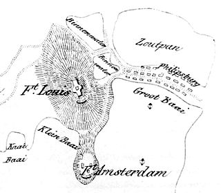
Fort Amsterdam is a historic fort on the island of Saint Martin, near the Sint Maarten town of Philipsburg.
Jan, Johan or Johannes van Walbeeck was a Dutch navigator and cartographer during a 1620s circumnavigation of the earth, an admiral of the Dutch West India Company, and the first governor of the Netherlands Antilles.

The languages of the Caribbean reflect the region's diverse history and culture. There are six official languages spoken in the Caribbean:
The Attack on Saint Martin was a failed attempt by the Dutch Republic to recapture the island and former base of the Dutch West India Company (WIC) from the Spanish. In 1633 the Spanish had invaded Saint-Martin and Anguilla, driving off the French and Dutch inhabitants. The French and Dutch banded together to repel the Spanish and it was during a 1644 sea battle that the Dutch commander Peter Stuyvesant, later the governor of New Amsterdam, unsuccessfully besieged Fort Amsterdam and was forced to retreat with the loss of hundreds of men. A stray Spanish cannonball shattered his leg, which had to be amputated. But luck was on the Dutch side, and when the Eighty Years' War between Spain and the Netherlands ended, the Spanish no longer needed a Caribbean base and just sailed away in 1648.
In Sint Maarten, a Dutch Caribbean constituent country of the Kingdom of the Netherlands, foreign policy is set by the Netherlands but all other laws including those related to abortion are self-determined. Abortion in Sint Maarten is illegal, although it may be permissible in circumstances where a pregnancy threatens the woman's life. Despite its illegality, abortions are routinely performed by some medical practitioners and are ignored by authorities.
Robert de Longvilliers de Poincy was a French local governor of Saint Christophe and Saint Martin in the French Antilles. His uncle, Phillippe de Longvilliers de Poincy, was commander of the French colonies in the Antilles from 1639 to 1651, then commander of the colonies of Saint Christophe, Saint Croix, Saint Barthélemy, and Saint Martin for the Knights of Malta. Longvilliers reestablished French control of the northern part of Saint Martin after the Spanish withdrew and the Dutch tried to take over the whole island.

The Saint Martin–Sint Maarten border, or France–Netherlands border, is the border between the Collectivity of Saint Martin, an overseas collectivity of France, and Sint Maarten, a constituent country of the Kingdom of the Netherlands, on the island of Saint Martin in the Caribbean. The 87-square-kilometre (34 sq mi) island is divided roughly 60:40 between the French Republic and the Kingdom of the Netherlands by the 16 km (10 mi) border, however the two parts are roughly equal in population.


