The Louisville Water Company is a water company based in Louisville, Kentucky.

Crescent Hill is a neighborhood four miles (6 km) east of downtown Louisville, Kentucky USA. This area was originally called "Beargrass" because it sits on a ridge between two forks of Beargrass Creek. The boundaries of Crescent Hill are N Ewing Ave to the St. Matthews city limit by Brownsboro Road to Lexington Road. Frankfort Avenue generally bisects the neighborhood.

The table below includes sites listed on the National Register of Historic Places (NRHP) in Jefferson County, Kentucky except those in the following neighborhoods/districts of Louisville: Anchorage, Downtown, The Highlands, Old Louisville, Portland and the West End. Links to tables of listings in these other areas are provided below.
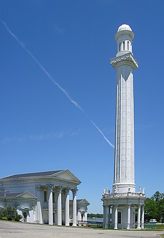
The Louisville Water Tower, located east of downtown Louisville, Kentucky near the riverfront, is the oldest ornamental water tower in the world, having been built before the more famous Chicago Water Tower. Both the actual water tower and its pumping station are a designated National Historic Landmark for their architecture. As with the Fairmount Water Works of Philadelphia, the industrial nature of its pumping station was disguised in the form of a Roman temple complex.

The Union Monument in Louisville is located in Cave Hill Cemetery in Louisville, Kentucky. It was built in 1914 from granite, honoring unknown soldiers who fought in the Union during the American Civil War. It is in front of the large number of Union soldiers buried at Cave Hill.
This is a list of properties and historic districts on the National Register of Historic Places in downtown Louisville, Kentucky. Latitude and longitude coordinates of the 85 sites listed on this page may be displayed in a map or exported in several formats by clicking on one of the links in the adjacent box.
St. Mary's College was a Catholic institution established by William Byrne and George Elder in Elder's hometown of Hardin's Creek near Lebanon in Marion County, Kentucky. The community was later renamed "St. Mary" after the college. St. Mary's is now closed. It operated between 1821 and 1976. Before it closed, it was the third oldest operating Catholic college for boys in the nation.
This is a list of properties and historic districts on the National Register of Historic Places in Anchorage, Kentucky. Latitude and longitude coordinates of the 35 sites listed on this page may be displayed in a map or exported in several formats by clicking on one of the links in the adjacent box.
This is a list of properties and historic districts on the National Register of Historic Places in the Portland neighborhood of Louisville, Kentucky (roughly bounded by the Ohio River on the north; N. 10th St. to the east; W. Market St. to the south; and I-264 and the Shawnee Golf Course to the west. Latitude and longitude coordinates of the 35 sites listed on this page may be displayed in a map or exported in several formats by clicking on one of the links in the adjacent box.
This is a list of properties and historic districts on the National Register of Historic Places in the West End of Louisville, Kentucky. The table below includes 49 listings in the following neighborhoods:

This is a list of the National Register of Historic Places listings in Bracken County, Kentucky.

This is a list of the National Register of Historic Places listings in Boyd County, Kentucky.
This is a list of the National Register of Historic Places listings in Clark County, Kentucky.

The Fisher Hill Reservoir and Gatehouse are historic elements of the public water supply for the Greater Boston area.

This is a list of the National Register of Historic Places listings in Clark County, Indiana.

This is a list of the National Register of Historic Places listings in Clay County, Kentucky.
This is a list of properties and historic districts on the National Register of Historic Places in The Highlands, Louisville, Kentucky. The table below includes 30 listings in the following neighborhoods:
This is a list of properties and historic districts on the National Register of Historic Places in Old Louisville, Kentucky. Latitude and longitude coordinates of the 33 sites listed on this page may be displayed in a map or exported in several formats by clicking on one of the links in the adjacent box.
Victor Andre Matteson was an American architect. His practice was based in Chicago and LaSalle, Illinois.
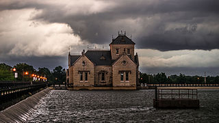
Crescent Hill Reservoir is a historic site in Crescent Hill, Louisville, Kentucky. It is listed on the National Register of Historic Places. Historic tours and walks have been hosted at the site and it is a popular area for walkers and runners. It is located at the intersection of Reservoir Avenue and 3018 Frankfort Avenue.


