
Berrien County is a county in the U.S. state of Michigan. It is located at the southwest corner of the state's Lower Peninsula, located on the shore of Lake Michigan and sharing a land border with Indiana. As of the 2020 Census, the population was 154,316. The county seat is St. Joseph.

The Potawatomi, also spelled Pottawatomi and Pottawatomie, are a Native American people of the Great Plains, upper Mississippi River, and western Great Lakes region. They traditionally speak the Potawatomi language, a member of the Algonquian family. The Potawatomi call themselves Neshnabé, a cognate of the word Anishinaabe. The Potawatomi are part of a long-term alliance, called the Council of Three Fires, with the Ojibwe and Odawa (Ottawa). In the Council of Three Fires, the Potawatomi are considered the "youngest brother". Their people are referred to in this context as Bodéwadmi, a name that means "keepers of the fire" and refers to the council fire of three peoples.

The Territory of Michigan was an organized incorporated territory of the United States that existed from June 30, 1805, until January 26, 1837, when the final extent of the territory was admitted to the Union as the State of Michigan. Detroit was the territorial capital.

Westport is a historic neighborhood and a main entertainment district in Kansas City, Missouri.
Louis Campau, also spelled Louis Campeau, was an important figure in the early settlement of Saginaw and Grand Rapids - two important Michigan cities in which he had established trading posts. Campau was also involved in negotiations between the local Native Americans and the federal government, including the Treaty of Detroit signed in 1855 by the local chief, Cobmoosa.

The Treaty of St. Mary's may refer to one of six treaties concluded in fall of 1818 between the United States and Natives of central Indiana regarding purchase of Native land. The treaties were

The Treaty of Fort Meigs, also called the Treaty of the Maumee Rapids, formally titled, "Treaty with the Wyandots, etc., 1817", was the most significant Indian treaty by the United States in Ohio since the Treaty of Greenville in 1795. It resulted in cession by bands of several tribes of nearly all their remaining Indian lands in northwestern Ohio. It was the largest wholesale purchase by the United States of Indian land in the Ohio area. It was also the penultimate one; a small area below the St. Mary's River and north of the Greenville Treaty Line was ceded in the Treaty of St. Mary's in 1818.

Isaac McCoy was an American pioneer and Baptist missionary among the Native Americans in what became the states of Indiana, Michigan, Missouri, and Kansas.
Note: There are multiple treaties referred to as Treaty with the Potawatomi. See Treaty with the Potawatomi for others.

The Yellow River is a 62.3-mile-long (100.3 km) tributary of the Kankakee River in the Central Corn Belt Plains ecoregion, located in northern Indiana in the United States. Via the Kankakee and Illinois rivers, it is part of the watershed of the Mississippi River, draining an area of 427 square miles (1,110 km2).

Johnston Lykins was a pioneering Baptist missionary to Native American tribes, and a founding civic booster in the frontier boomtowns of West Port and Kansas, Missouri, which combined and became Kansas City, Missouri.
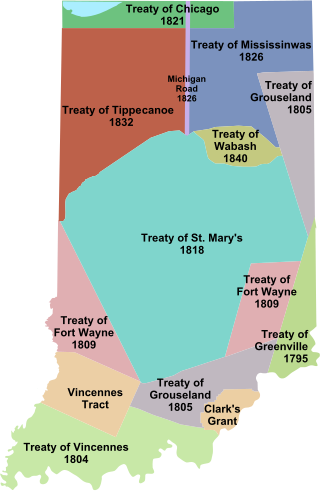
Indian removals in Indiana followed a series of the land cession treaties made between 1795 and 1846 that led to the removal of most of the native tribes from Indiana. Some of the removals occurred prior to 1830, but most took place between 1830 and 1846. The Lenape (Delaware), Piankashaw, Kickapoo, Wea, and Shawnee were removed in the 1820s and 1830s, but the Potawatomi and Miami removals in the 1830s and 1840s were more gradual and incomplete, and not all of Indiana's Native Americans voluntarily left the state. The most well-known resistance effort in Indiana was the forced removal of Chief Menominee and his Yellow River band of Potawatomi in what became known as the Potawatomi Trail of Death in 1838, in which 859 Potawatomi were removed to Kansas and at least forty died on the journey west. The Miami were the last to be removed from Indiana, but tribal leaders delayed the process until 1846. Many of the Miami were permitted to remain on land allotments guaranteed to them under the Treaty of St. Mary's (1818) and subsequent treaties.
Jotham Meeker was a Baptist missionary, printer, who lived and proselytized among various Native American peoples, including the Delaware, Ottawa, and Shawnee. He was born near Cincinnati, Ohio, and at the age of 21 became a teacher of the Indians, first at Carey Station, headed by Isaac McCoy. near present-day Niles, Michigan, November, 1825. Also joining the Station was 17-year-old Eleanor Richardson, who later became Jotham's wife.

Menominee was a Potawatomi chief and religious leader whose village on reservation lands at Twin Lakes, 5 miles (8.0 km) southwest of Plymouth in present-day Marshall County, Indiana, became the gathering place for the Potawatomi who refused to remove from their Indiana reservation lands in 1838. Their primary settlements were at present day Myers Lake and Cook Lake. Although Menominee's name and mark appear on several land cession treaties, including the Treaty of St. Mary's (1818), the Treaty of Mississinewas (1826), the Treaty of Tippecanoe (1832), and a treaty signed on December 16, 1834, he and other Potawatomi refused to take part in subsequent land cession negotiations, including the Treaty of Yellow River (1836), that directly led to the forced removal of Menominee's band from Indiana in 1838.

The recorded history of Grand Rapids in the U.S. state of Michigan, began with settlers in 1806.
Keewaycooshcum (d.1839), also spelled Keewacoosheum, Kewikishkum, or Kewaykishkum, was a leader of the Grand River Band of Ottawa Nation Native Americans at the Flat River in what would become the U.S. state of Michigan. In 1821, he defied his tribe and signed the Treaty of Chicago, ceding all Ottawa territory south of the Grand River to the United States. After signing the treaty, Keewaycooshcum was exiled by his band north to the Manistee River. Over the following decades, he and his family were murdered for his role in the treaty.

Noahquageshik, also spelled Nawehquageezhik, Nawehquageezhig, or Nowgeschick, and better known as Chief Noonday, was a chief of the Grand River Band of Ottawa Nation Native Americans in what would become the U.S. state of Michigan.
Wabiwindego (d.1837), also spelled Wobwindego, Wobiwidigo, or Wabaningo, and known among the Ojibwe as Waabishkindip, was a leader of the Grand River Band of Ottawa in what would become the U.S. State of Michigan. He negotiated the 1836 Treaty of Washington with the federal government on behalf of the Grand River Ottawa, leading to the admission of the State of Michigan to the Union. Several villages he led formed the basis for several modern Michigan towns, including Lowell, Whitehall, and Montague.

The 1833 Treaty of Chicago was an agreement between the United States government and the Chippewa, Odawa, and Potawatomi tribes. It required them to cede to the United States government their 5,000,000 acres (2,000,000 ha) of land in Illinois, the Wisconsin Territory, and the Michigan Territory and to move west of the Mississippi River. In return, the tribes were given promises of various cash payments and tracts of land west of the Mississippi River. The treaty was one of the removal treaties to come after the passage of the Indian Removal Act. It was the second treaty referred to as the "Treaty of Chicago," after the 1821 Treaty of Chicago.
