Caribbean natural region

Last updated
Caribbean region
Mapa de Colombia (region del Caribe).svg
Ecology
Realm Neotropic
Biome Marine, Dry Forest, Rainforest, Montane Forest, Páramo, Desert, Wetlands
Geography
CountryFlag of Colombia.svg  Colombia
Oceans or seas Caribbean Sea
Rivers Sinú, Magdalena, Ranchería
Climate type Tropical
Conservation
Global 200 Sierra Nevada de Santa Marta, Ciénaga Grande

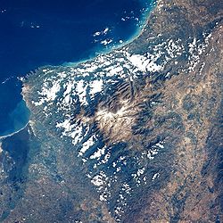
The Caribbean region is mostly lowland plains extending from the northern reaches of the Colombian Andes to the Caribbean Sea that are characterized by a variety of ecosystems including: humid forests, dry forests, savannas, wetlands and desert. The Sierra Nevada de Santa Marta rise from the plains to snow-capped peaks, separated from the Andes as an isolated area of high biodiversity and endemism. It contains one of the largest marshes in Colombia, the Ciénaga Grande de Santa Marta. The main river is the Magdalena which is fully navigable in the region and a major path for the flow of shipments to and from inland Colombia.

Contents

Biogeographical subregions

The Caribbean region contains 6 subregions which differ in certain natural aspects.

Guajira Peninsula

The Guajira Peninsula on the left of Gulf of Venezuela and south of the Caribbean Sea. The peninsula is the northernmost point of Colombia and South America. Guajirapeninsula1.png
The Guajira Peninsula on the left of Gulf of Venezuela and south of the Caribbean Sea. The peninsula is the northernmost point of Colombia and South America.

The Guajira Peninsula is the most northerly point of South America and mostly desertic due to the rain shadow of the high Sierra Nevada de Santa Marta and is only crossed by the Ranchería River with no other major water courses in the area; thus water is scarce. A small mountain range, the Serranía de Macuira, is located in the tip of the peninsula and contains a unique dwarf cloud forest completely surrounded by desert. Large estuaries near Riohacha are protected as the SFF Los Flamencos which is meant to protect the habitat for the American flamingo.

Sierra Nevada de Santa Marta

the Sierra Nevada de Santa Marta as viewed from space. Sierra Nevada de Santa Marta desde el espacio.jpg
the Sierra Nevada de Santa Marta as viewed from space.

Caribbean Savanna and Magdalena Delta

The Magdalena River basin extends from the Andes through the Magdalena River valley and into the Caribbean plains, where major tributaries integrate into the floodplain. The massive Ciénaga Grande de Santa Marta is situated between the delta and the base of the Sierra Nevada de Santa Marta.

The Caribbean savanna extends from the delta west toward the Sinú River. A small range of mountains called the Montes de María are found here and part of them are protected as the Los Colorados Sanctuary.

Valley of the San Jorge River

The San Jorge River rises in the northern end of the West Andes and flows northeast to flow into the Cauca River. Large swaths of the valley are covered by marshes like the Ciénaga de Ayapel.

Valley of the Sinú River

The Sinú River flows through the Sinú Valley dry forests ecoregion.

Gulf of Urabá

The Gulf of Urabá

Protected areas

See also

Related Research Articles

<span class="mw-page-title-main">Geography of Colombia</span> Overview of the geography of Colombia

The Republic of Colombia is situated largely in the north-west of South America, with some territories falling within the boundaries of Central America. It is bordered to the north-west by Panama; to the east by Brazil and Venezuela; to the south by Ecuador and Peru; and it shares maritime limits with Costa Rica, Nicaragua, Honduras, Jamaica, the Dominican Republic, and Haiti.

<span class="mw-page-title-main">Magdalena Department</span> Department of Colombia

Magdalena is a department of Colombia with more than 1.3 million people, located to the north of the country by the Caribbean Sea. The capital of the Magdalena Department is Santa Marta and was named after the Magdalena River. It inherited the name of one of the original nine states of the United States of Colombia that its current territory integrated.

<span class="mw-page-title-main">Cesar Department</span> Department of Colombia

Cesar Department or simply Cesar is a department of Colombia located in the north of the country in the Caribbean region, bordering to the north with the Department of La Guajira, to the west with the Department of Magdalena and Department of Bolivar, to the south with Department of Santander, to the east with the Department of North Santander, and further to the east with the country of Venezuela. The department capital city is Valledupar.

<span class="mw-page-title-main">Magdalena River</span> River in Colombia

The Magdalena River is the main river of Colombia, flowing northward about 1,528 kilometres (949 mi) through the western half of the country. It takes its name from the biblical figure Mary Magdalene. It is navigable through much of its lower reaches, in spite of the shifting sand bars at the mouth of its delta, as far as Honda, at the downstream base of its rapids. It flows through the Magdalena River Valley.

<span class="mw-page-title-main">Sierra Nevada de Santa Marta</span> Mountain range in northern Colombia

The Sierra Nevada de Santa Marta is an isolated mountain range in northern Colombia, separate from the Andes range that runs through the north of the country. Reaching an elevation of 5,700 m (18,700 ft) just 42 km (26 mi) from the Caribbean coast, the Sierra Nevada is the highest coastal range in the tropics, and one of the highest coastal ranges in the world, being 250 metres (820 ft) shorter than the Saint Elias Mountains in Canada. The Sierra Nevada encompasses about 17,000 km2 (6,600 sq mi) and serves as the source of 36 rivers. The range is in the Departments of Magdalena, Cesar and La Guajira.

<span class="mw-page-title-main">Guajira Peninsula</span> Geographic feature in northeastern Colombia and northwestern Venezuela

The Guajira Peninsula is a peninsula in northern Colombia and northwestern Venezuela in the Caribbean. It is the northernmost peninsula in South America and has an area of 25,000 km2 (9,700 sq mi) extending from the Manaure Bay (Colombia) to the Calabozo Ensenada in the Gulf of Venezuela (Venezuela), and from the Caribbean to the Serranía del Perijá mountains range.

<span class="mw-page-title-main">Cordillera Central (Colombia)</span> Branch of the Colombian Andes

The Cordillera Central is the highest of the three branches of the Colombian Andes. The range extends from south to north dividing from the Colombian Massif in Cauca Department to the Serranía de San Lucas in Bolivar Departments. The highest peak is Nevado del Huila at 5,364 m (17,598 ft).

<span class="mw-page-title-main">Cordillera Occidental (Colombia)</span> Mountain range in Colombia

The Cordillera Occidental is the lowest in elevation of the three branches of the Colombian Andes. The average altitude is 2,000 m (6,600 ft) and the highest peak is Cerro Tatamá at 4,100 m (13,500 ft). The range extends from south to north dividing from the Colombian Massif in Nariño Department, passes north through Cauca, Valle del Cauca, Risaralda, Chocó, and Caldas Departments to the Paramillo Massif in Antioquia and Córdoba Departments. The cordillera is paralleled on the east by the Cauca river. From this massif the range divides further to form the Serranías de Ayapel, San Jerónimo and Abibe. Only to recede into the Caribbean plain and the Sinú River valley.

<span class="mw-page-title-main">La Guajira Department</span> Department of Colombia

La Guajira is a department of Colombia. It occupies most of the Guajira Peninsula in the northeast region of the country, on the Caribbean Sea and bordering Venezuela, at the northernmost tip of South America. The capital city of the department is Riohacha.

<span class="mw-page-title-main">Ciénaga Grande de Santa Marta</span>

The Ciénaga Grande de Santa Marta is the largest of the swampy marshes located in Colombia between the Magdalena River and the Sierra Nevada de Santa Marta. It has an area of 4280 km2 and belongs to the outer delta system of the Madgalena River. It is separated from the Caribbean Sea by a narrow, sandy artificial spit built in the 1950s, on which is situated coastal route 90 from Barranquilla to Santa Marta. The marsh's large lagoon is connected to the Caribbean Sea via a narrow strait located between the town of Pueblo Viejo and the city of Ciénaga.

<span class="mw-page-title-main">Fundación River</span>

The Fundación River is a river in northern Colombia, originating from the Sierra Nevada de Santa Marta in the Cesar Department but flows down to the Magdalena Department crossing the town and municipality of Fundación before reaching the Ciénaga Grande de Santa Marta.

<span class="mw-page-title-main">Serranía de Macuira</span>

Serranía de Macuira is a mountain range in northern Colombia located in the municipality of Uribia, La Guajira. The Serrania de Macuira stands in the middle of the La Guajira Desert at 864 m (2,835 ft) isolated from the Sierra Nevada de Santa Marta and the Eastern Ranges of the Colombian Andes. The range is a protected area; National Natural Park Macuira.

<span class="mw-page-title-main">Natural regions of Colombia</span>

Because of its natural structure, Colombia can be divided into six distinct natural regions. These consist of the Andean Region, covering the three branches of the Andes mountains found in Colombia; the Caribbean Region, covering the area adjacent to the Caribbean Sea; the Pacific Region adjacent to the Pacific Ocean; the Orinoquía Region, part of the Llanos plains mainly in the Orinoco river basin along the border with Venezuela; the Amazon Region, part of the Amazon rainforest; and finally the Insular Region, comprising the islands in both the Atlantic and Pacific Oceans. Colombia is located in South America.

<span class="mw-page-title-main">Geography of Cesar Department</span>

The Geography of Cesar Department is part of the geography of Colombia, located within the Colombian Caribbean region contiguous to the Caribbean sea however, the Cesar Department is the only department in the Caribbean region without access border to the sea. The geography of Cesar Department is characterized for being mostly a valley which is formed by the Sierra Nevada de Santa Marta, the basin of the Cesar River and the Serrania del Perijá, this last one part of the Andes mountain range. To the south the valley ends in the Ciénaga de la Zapatosa contiguous to the Magdalena River and the mountain range of the Serrania de San Lucas, also part of the Andes. The southern Cesar is considered to be part of the Andean Region of Colombia.

<span class="mw-page-title-main">Santa Marta páramo</span>

The Santa Marta páramo (NT1007) is an ecoregion containing páramo vegetation above the treeline in the Sierra Nevada de Santa Marta mountain range on the Caribbean coast of Colombia. The isolated position of the range has allowed unique species to evolve. Some are related to those found in Central America and the Caribbean coastal areas, and some to species from the Andes. The habitat is relatively stable, but has been drastically changed from the original by long-term human activity.

<span class="mw-page-title-main">Sinú Valley dry forests</span>

The Sinú Valley dry forests (NT0229) is an ecoregion in the north of Colombia.

<span class="mw-page-title-main">Santa Marta montane forests</span>

The Santa Marta montane forests (NT0159) is an ecoregion in the Sierra Nevada de Santa Marta, a massif on the Caribbean coast of northern Colombia. The ecoregion covers altitudes from near sea level up to around 3,300 metres (10,827 ft), where it gives way to Santa Marta páramo. The isolation of the massif and the range of elevations and climates has resulted in a wide variety of species including many endemics. The lower levels contained tropical rainforest, which has largely been cleared. Higher up, this gives way to cloud forest. Much of this has also been cleared for coffee plantations, pasture for sheep and cattle, and farming.

<span class="mw-page-title-main">Bucaramanga-Santa Marta Fault</span> Colombian fault system

The Bucaramanga-Santa Marta Fault or Bucaramanga-Santa Marta Fault System is a major oblique transpressional sinistral strike-slip fault in the departments of Magdalena, Cesar, Norte de Santander and Santander in northern Colombia. The fault system is composed of two main outcropping segments, named Santa Marta and Bucaramanga Faults, and an intermediate Algarrobo Fault segment in the subsurface. The system has a total length of 674 kilometres (419 mi) and runs along an average north-northwest to south-southeast strike of 341 ± 23 from the Caribbean coast west of Santa Marta to the northern area of the Eastern Ranges of the Colombian Andes.

<span class="mw-page-title-main">La Guajira Terrane</span> Geological province in Colombia

La Guajira Terrane is one of the geological provinces (terranes) of Colombia. The terrane, dating to the Late Cretaceous, is situated on the North Andes Plate and borders the Caribbean, Tahamí and Chibcha Terranes along the Bucaramanga-Santa Marta Fault. The southern boundary is formed by the Oca Fault with the Chibcha Terrane.

<span class="mw-page-title-main">Magdalena–Santa Marta mangroves</span>

The Magdalena-Santa Marta mangroves ecoregion covers the mangrove forests along the coast of Colombia on the Caribbean Sea, from Gulf of Urabá in the west at the Colombia-Panama border to the Guajira Peninsula in the east. The region is relatively dry, with low precipitation and high evapotranspiration, so the mangroves depend for water and nutrients on the rivers flowing across the estuarine plain from the Sierra Nevada de Santa Marta mountains to the east. Efforts are currently underway to restore mangroves degraded by development and road building from the 1950s to 1980s.

References