The Metropolitan Borough of Barnsley is a metropolitan borough in South Yorkshire, England; the main settlement is Barnsley and other notable towns include Penistone, Wombwell and Hoyland.

Brierley is a village in the Metropolitan Borough of Barnsley in South Yorkshire, England. The settlement is tightly clustered and green buffered on a modest escarpment close to the border with West Yorkshire, it is almost wholly in population south of the A628 road, and is less than 2 miles (3 km) to the south west of Hemsworth.

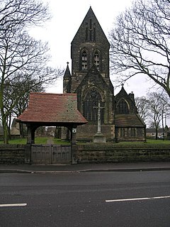
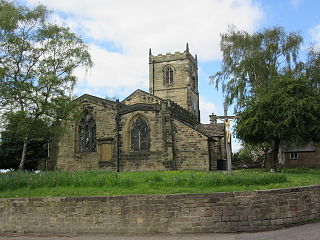
Royston is a suburban village within the Metropolitan borough of Barnsley, in South Yorkshire, England. Historically, the village formed part of the West Riding of Yorkshire, but was incorporated into the Metropolitan borough of Barnsley in 1974 and is now on the border with West Yorkshire. It is part of the Barnsley Central borough constituency, and has a population of 10,728. It is situated 4 miles (6.4 km) north-east of Barnsley, and 6 miles (9.7 km) south-east of Wakefield.

Barugh is a village in the metropolitan borough of Barnsley in South Yorkshire, England. The village falls within the Barnsley Metropolitan ward of Darton West. Until 1974 it was in the West Riding of Yorkshire.

Ardsley is a small village approximately 3 miles (5 km) east from Barnsley and forms part of the Metropolitan Borough of Barnsley of South Yorkshire, England. The village is in the Stairfoot ward of Barnsley Metropolitan Council. It is historically part of the West Riding of Yorkshire. The A635 divides the village into two parts.

Ingbirchworth is a village and former civil parish, now in the parish of Gunthwaite and Ingbirchworth, in the Barnsley district, in the county of South Yorkshire, England. It is on the boundary of Kirklees in West Yorkshire. At the 2001 Census, the parish had a population of 400, increasing to 460 at the 2011 Census, and now estimated to be around 600.

Warley Town is a settlement near Halifax, in the Calderdale district, in the county of West Yorkshire, England. Warley is a ward of Calderdale. The population of this ward as taken at the 2011 Census was 12,215.
Barlby is a linear village in the civil parish of Barlby with Osgodby, in North Yorkshire, England. It is situated 2 miles (3 km) to the north-east of the market town of Selby, and is bordered to the west by the River Ouse and to the east by the A19 Barlby bypass. Across the bypass is Barlby's smaller sister village, Osgodby.

Kilton is a village in the civil parish of Lockwood, in the borough of Redcar and Cleveland, in the ceremonial county of North Yorkshire, England.

Buckton is a small village and former civil parish, now in the parish of Bempton, in the East Riding of Yorkshire, England. It is near the North Sea coast, and about 4 miles (6 km) north of Bridlington. It lies on the B1229 road. In 1931 the parish had a population of 174.

Greasbrough is a small suburb in Rotherham, in South Yorkshire, England. The suburb falls in the Greasbrough Ward of Rotherham Metropolitan Borough Council. Greasbrough had its own local council, Greasbrough UDC, until its absorption into the County Borough of Rotherham in 1936. Until 1974 it was in the West Riding of Yorkshire.
Thurlstone is a village and former civil parish, now in the parish of Penistone, in the metropolitan borough of Barnsley, in South Yorkshire, England. Originally it was a small farming community. Some industries developed using water power from the River Don such as corn milling, wire drawing and various wool and cloth processes. Most of these are now gone and only James Durrans and Service Direct owned by 'Don Eddie' remain. The village is now a dormitory for the urban areas of South and West Yorkshire. The village now falls in the Penistone West ward of the Barnsley MBC.
Bolton upon Dearne is a village in the Metropolitan Borough of Barnsley, South Yorkshire, England, in the part of the Dearne Valley through which the River Dearne passes. Historically part of the West Riding of Yorkshire, it is approximately 7 miles (11 km) east of Barnsley, 10 miles (16 km) west of Doncaster and 8 miles (13 km) north of Rotherham.
Edward Sheerien School was a comprehensive school in Barnsley, South Yorkshire, England. It had approximately 800 pupils, ages 11–16. The school was where a large portion of the motion picture Kes was filmed in 1969.

Ulrome is a village and civil parish in the East Riding of Yorkshire, England. It is situated approximately 6 miles (9.7 km) north of the town of Hornsea and on the east side of the B1242 road. The parish includes the village of Lissett. Its area is 1,139.535 hectares, in 2011 had a population of 239, a reduction on the 2001 UK census figure of 260.

South Cliffe is a village and civil parish in the East Riding of Yorkshire, England. It is situated about 2.5 miles (4 km) north of North Cave, 2 miles (3.2 km) west of Newbald and about 3.5 miles (5.6 km) south of Market Weighton. It bestrides Cliffe Road. The parish includes the village of North Cliffe.
Out Newton is a hamlet in the civil parish of Easington, in the East Riding of Yorkshire, England, in an area known as Holderness. It is situated just inland from the North Sea coast, approximately 4.5 miles (7.2 km) south-east of Withernsea, and 4.5 miles (7.2 km) east of Patrington.
Ousefleet is a small hamlet and former civil parish, now in the parish of Twin Rivers, in the East Riding of Yorkshire, England approximately 5 miles (8 km) east of Goole. It is located just south of the River Ouse and north of the A161 road between Goole and Scunthorpe. In 1961 the parish had a population of 167.

Barkisland is a village in Calderdale, West Yorkshire, England. Historically part of the West Riding of Yorkshire, it is 1 mile (1.6 km) east of Ripponden, 2 miles (3.2 km) south of Sowerby Bridge and 4 miles (6.4 km) south-west of Halifax town centre.