Carmelo, Uruguay

Last updated
Carmelo
City
Rambla de los Constituyentes.jpg
The Swing Bridge of Carmelo over the Arroyo de las Vacas
Bandera de Carmelo.jpg
Escudo de carmelo.png
Uruguay location map.svg
Red pog.svg
Carmelo
Coordinates: 34°00′0″S58°17′0″W / 34.00000°S 58.28333°W / -34.00000; -58.28333
CountryFlag of Uruguay.svg  Uruguay
Department Flag of Colonia Department.svg  Colonia
Founded12 February 1816
Founded byJosé Gervasio Artigas
Population
 (2011 Census)
  Total18,041
Time zone UTC -3
Postal code
70100
Dial plan +598 4542 (+4 digits)
Website http://www.ciudadcarmelo.com/

Carmelo is a city located in the department of Colonia of western Uruguay, noted for its wineries. [1]

Contents

Geography

Location

Route 21 passes through the city, joining it with Nueva Palmira to the northwest and Colonia del Sacramento to the southeast.

History

During the beginning of the Conquest of the 16th century, the Spanish founded the Fuerte de San Lázaro (April 7, 1527 - October 1530). In 1611, Hernando Arias de Saavedra, governor of Asuncion, landed cattle near the mouth of the Arroyo de las Vacas. [1] A populated centre was established here which had reached the status of "Pueblo" (village) before the Independence of Uruguay. The present city was founded by José Gervasio Artigas on 12 February 1816. [2] Its status was elevated to "Ciudad" (city) on 17 August 1920 by the Act of Ley Nº 7.257. [3] It is the only city founded personally by the Uruguayan national hero, and it still holds this office proudly.

Population

In 2011 Carmelo had a population of 18,041. [4]

YearPopulation
19089,364
196312,705
197513,707
198514,278
199616,658
200416,866
201118,041

Source: Instituto Nacional de Estadística de Uruguay [3]

Landmarks

View of Carmelo's beach Praia de Carmelo.JPG
View of Carmelo's beach

There are two squares in the city. The one is Plaza Artigas, with a monument to the foundation of the city, the church Templo Histórico del Carmen and the city museum and archive. The other, more central square is the commercial centre of the city. The main commercial street is 19 de Avril, which at its south ends at the bridge, after which it becomes Route 21 which joins it with Colonia del Sacramento and also forks towards other destinations.[ citation needed ]

Hotel Casino de Carmelo Hotel Casino de Carmelo.jpg
Hotel Casino de Carmelo

The river Arroyo de las Vacas runs along the east and south part of the city. This river serves as a port for the town. On its north bank there is the Puerto Carmelo-Tigre, where small catamaran boats carry passengers across the Río de la Plata to Argentina. A swing bridge, the Puente Giratorio de Carmelo, which opened on 1 May 1912, passes over the Arroyo de las Vacas. The bridge joins the north part of the city with its small southern part, where another port along the southern banks of the river accommodates private boats and the Yacht Club Carmelo. In the same part, along the coast there is beach Playa Seré, a park, a small zoological garden and a Casino Hotel.[ citation needed ]

Places of worship

Symbols of Carmelo

Flag of Carmelo Bandera de Carmelo.jpg
Flag of Carmelo
Seal of Carmelo Escudo de carmelo.png
Seal of Carmelo
Wines of Carmelo The Bottle of Carmelo.jpg
Wines of Carmelo

The area around the city

Between Nueva Palmira and Carmelo there is a stretch along the Río Uruguay of great tourist importance. Points of interest in this area are Punta Gorda, Zagarzazú and Colonia Estrella. In Zagarzazú there is a small airport and a luxury hotel, the Four Seasons Carmelo Hotel, with an important golf course. [5]

Just northwest of Carmelo is Juncal Island which once held a notorious prison. [6] The city is a few kilometers from the town of Las Víboras.

Notable people

Related Research Articles

The transport network in Uruguay consists of 1,673 km of rail network, 7,743 km of paved roads, 1,600 km of navigable waterways, and 11 airports with paved roads.

<span class="mw-page-title-main">Colonia del Sacramento</span> Capital city in Colonia, Uruguay

Colonia del Sacramento is a city in southwestern Uruguay, by the Río de la Plata, facing Buenos Aires, Argentina. It is one of the oldest towns in Uruguay and the capital of the Colonia Department. It has a population of around 27,000.

<span class="mw-page-title-main">Fray Bentos</span> Capital city in Río Negro Department, Uruguay

Fray Bentos is the capital city of the Río Negro Department, in south-western Uruguay, at the Argentina-Uruguay border, near the Argentine city of Gualeguaychú. Its port on the Uruguay River is one of the nation's most important harbours. The city hosts the first campus of the Technological University, beside the historically relevant industrial complex Anglo, a World Heritage Site.

Río Negro Department is a department of the northwestern region of Uruguay. It has an area of 9,282 km2 (3,584 sq mi) and a population of 54,765. Its capital is Fray Bentos. It borders Paysandú Department to the north, Tacuarembó Department to the east, Durazno Department to the southeast, Soriano Department to the south and has the Río Uruguay flowing at its west, separating it from Argentina.

Banda Oriental, or more fully Banda Oriental del Uruguay, was the name of the South American territories east of the Uruguay River and north of Río de la Plata that comprise the modern nation of Uruguay, the modern state of Rio Grande do Sul, Brazil, and part of the modern state of Santa Catarina, Brazil. It was the easternmost territory of the Viceroyalty of the Río de la Plata.

<span class="mw-page-title-main">Salto, Uruguay</span> Department capital city in Salto, Uruguay

Salto is the capital city of the Salto Department in northwestern Uruguay. As of the 2011 census it had a population of 104,028 and is the second most populated city in Uruguay, after Montevideo.

<span class="mw-page-title-main">Colón, Entre Ríos</span> City in Entre Ríos, Argentina

Colón is a city in the province of Entre Ríos, Argentina. It is located in the east of the province, on the western shore of the Uruguay River, and has about 23,000 inhabitants. It lies opposite Paysandú, Uruguay, to which it is linked across the river by the General Artigas Bridge.

<span class="mw-page-title-main">Nueva Palmira</span> City in Colonia, Uruguay

Nueva Palmira is a city in Colonia Department in south-western Uruguay.

<span class="mw-page-title-main">Montevideo Department</span> Department of Uruguay

Montevideo is a department (departamento) of Uruguay. It is by far the smallest department in area, but also by far the most populated. Its capital is the city of Montevideo, which is also the national capital. While most of the department is covered by the capital city, there are still smaller towns within its limits.

<span class="mw-page-title-main">Chuy</span> City in Rocha, Uruguay

Chuy is a city in the extreme east of Uruguay, in the Rocha Department, 340 kilometres (211 mi) northeast of Montevideo. It lies on the border with Brazil, separated from its Brazilian sister town of Chuí only by a shared avenue that serves as the border, and by the Arroyo Chuy (stream) to the east. Chuy's population was 9,675 in 2011.

<span class="mw-page-title-main">Tourism in Uruguay</span>

Tourism in Uruguay is an important part of the nation's economy.

<span class="mw-page-title-main">Rail transport in Uruguay</span>

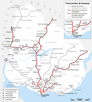
The Uruguayan railway network has about 2900 km (1802 mi) of lines, all of 1,435 mm gauge, diesel traction with only 11 km (7 mi) of double track. Only half of the network is currently active. All the Uruguayan lines start from Montevideo, connecting the cities of Paysandú, Salto, Rivera and Río Branco. The rest of the lines (closed) connected the capital city with Fray Bentos, Cuareim, Artigas, Km. 329, Melo, La Paloma and Colonia del Sacramento.

<span class="mw-page-title-main">Conchillas</span> Town in Colonia Department, Uruguay

Conchillas is a small industrial town located within the Colonia Department, in southwestern Uruguay.

<span class="mw-page-title-main">Rosario, Uruguay</span> City in Colonia, Uruguay

Rosario, also known as Rosario Oriental, Villa del Rosario, or Rosario del Colla, is a small city located within the Colonia Department, in southern Uruguay. It is home to about 10,000 people.

<span class="mw-page-title-main">Tarariras</span> City in Colonia, Uruguay

Tarariras, is a small city in the south of the Colonia Department of southern Uruguay.

Juan Lacaze, or Juan L. Lacaze, is a city located in southwestern Uruguay, within the Colonia Department.

Ombúes de Lavalle is a small city located in the north of Colonia Department in southwestern Uruguay. It is named after the Argentine General Juan Lavalle. The term «Ombúes» is the Spanish plural for «Ombú», a tree originary of the Pampas region, in southern South America, and a national symbol of both Argentina and Uruguay.

<span class="mw-page-title-main">Carmelo Bridge</span> Uruguayan bridge

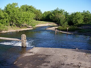
The Carmelo bridge is a swing bridge located over the Arroyo de las Vacas, near the city of Carmelo, Uruguay. Its turning mechanism is human-powered, which makes it the only one of its kind in Uruguay.
It is considered to be the first swing bridge in South America.

Las Víboras is a Uruguayan town in the Colonia Department which was one of the first towns in the Uruguayan countryside. A substantial portion of its population later became the base of the city of Carmelo.

References

  1. 1 2 Burford, Tim (2010). Uruguay. Bradt Travel Guides. p. 257. ISBN   978-1-84162-316-0 . Retrieved 9 June 2011.
  2. Pintos, Aníbal Barrios (2000). Historia de los pueblos orientales: sus orígenes, procesos fundacionales, sus primeros años. Academia Nacional de Letras. Retrieved 9 June 2011.
  3. 1 2 "Statistics of urban localities (1908–2004)" (PDF). INE. 2012. Archived from the original (PDF) on 2009-11-13. Retrieved 3 September 2012.
  4. "Censos 2011 Cuadros Colonia". INE. 2012. Retrieved 25 August 2012.
  5. Luongo, Michael; O'Malley, Charlie; Pashby, Christie (13 July 2007). Frommer's Argentina. Frommer's. pp. 175–. ISBN   978-0-470-12479-6 . Retrieved 9 June 2011.
  6. Bernhardson, Wayne (30 April 1996). Argentina, Uruguay & Paraguay: a Lonely Planet travel survival kit. Lonely Planet Publications. ISBN   978-0-86442-336-8 . Retrieved 9 June 2011.
  7. 1 2 3 "Olympic rowers from Uruguay" . Retrieved 11 March 2024.