Carmichaels, Pennsylvania

Last updated
Carmichaels, Pennsylvania
Carmichaels Bridge.jpg
Greene County Pennsylvania Incorporated and Unincorporated areas Carmichaels Highlighted.svg
Location of Carmichaels in Greene County, Pennsylvania.
USA Pennsylvania location map.svg
Red pog.svg
Carmichaels
Usa edcp location map.svg
Red pog.svg
Carmichaels
Coordinates: 39°53′52″N79°58′30″W / 39.89778°N 79.97500°W / 39.89778; -79.97500
CountryFlag of the United States.svg  United States
State Flag of Pennsylvania.svg  Pennsylvania
County Greene
Established1768
Government
  BodyCarmichaels Borough Council
  MayorMelodie Berardi (Democrat/Republican)
Area
[1]
  Total0.17 sq mi (0.44 km2)
  Land0.17 sq mi (0.43 km2)
  Water0.01 sq mi (0.01 km2)
Elevation
1,004 ft (306 m)
Population
 (2020) [2]
  Total432
  Density2,618.18/sq mi (1,011.47/km2)
Time zone UTC-4:00 (EST)
  Summer (DST) UTC-5:00 (EDT)
Area code 724
FIPS code 42-11328

Carmichaels is a borough in Greene County, Pennsylvania, United States. The population was 434 at the 2020 census, [3] a decline from the figure of 483 tabulated in 2010. [4]

Contents

History

The Carmichaels Covered Bridge and Greene Academy are listed on the National Register of Historic Places.

Carmichaels, Pennsylvania is quite famous in its area for the Coal Queen Pageant, an annual beauty pageant where girls from all over Greene County compete to be crowned Coal Queen. [5]

Education

Carmichaels is home to the school district of Carmichaels Area. There is an Elementary Center and a Jr/Sr High School on the same grounds, home of the Mighty Mikes.

Geography

Carmichaels is located in eastern Greene County at 39°53′52″N79°58′30″W / 39.89778°N 79.97500°W / 39.89778; -79.97500 (39.897755, -79.975022). [6] It is surrounded by Cumberland Township but is a separate municipality.

Pennsylvania Route 88 passes through the borough, leading north 9 miles (14 km) to Fredericktown and south 14 miles (23 km) to Point Marion.

According to the United States Census Bureau, Carmichaels has a total area of 0.17 square miles (0.44 km2), of which 0.004 square miles (0.01 km2), or 2.86%, is water. [4] Muddy Creek, a tributary of the Monongahela River, flows to the northeast through the northern corner of the borough, where it passes under the Carmichaels Covered Bridge on Old Town Road.

Demographics

Historical population
CensusPop.Note
1860 440
1870 49111.6%
1880 489−0.4%
1890 445−9.0%
1900 4562.5%
1910 4784.8%
1920 58121.5%
1930 70821.9%
1940 84719.6%
1950 8955.7%
1960 788−12.0%
1970 608−22.8%
1980 6303.6%
1990 532−15.6%
2000 5564.5%
2010 483−13.1%
2020 434−10.1%
2021 (est.)425 [3] −2.1%
Sources: [7] [8] [9] [10] [2]

As of the census [8] of 2000, there were 556 people, 232 households, and 141 families residing in the borough. The population density was 3,021.2 people per square mile (1,192.6/km2). There were 255 housing units at an average density of 1,385.6 per square mile (547.0/km2). The racial makeup of the borough was 98.20% White, and 1.80% from two or more races. Hispanic or Latino of any race were 0.18% of the population.

There were 232 households, out of which 26.3% had children under the age of 18 living with them, 42.7% were married couples living together, 14.7% had a female householder with no husband present, and 38.8% were non-families. 34.5% of all households were made up of individuals, and 19.8% had someone living alone who was 65 years of age or older. The average household size was 2.36 and the average family size was 3.03.

In the borough the population was spread out, with 23.4% under the age of 18, 8.1% from 18 to 24, 27.3% from 25 to 44, 24.8% from 45 to 64, and 16.4% who were 65 years of age or older. The median age was 40 years. For every 100 females there were 93.1 males. For every 100 females age 18 and over, there were 84.4 males.

The median income for a household in the borough was $33,462, and the median income for a family was $36,719. Males had a median income of $29,286 versus $20,125 for females. The per capita income for the borough was $14,979. About 8.3% of families and 10.4% of the population were below the poverty threshold, including 12.4% of those under age 18 and 8.3% of those age 65 or over.

Electric generating station

Carmichaels is home to the Hill Top Energy Center. A newly constructed natural gas-fired power plant with a generating capacity of 625 megawatts, it is scheduled to begin operations in the summer of 2021. [11] [12]

Notable people

Related Research Articles

<span class="mw-page-title-main">Rankin, Pennsylvania</span> Borough in Pennsylvania, United States

Rankin is a borough in Allegheny County, Pennsylvania, United States, 8 miles (13 km) south of Pittsburgh on the Monongahela River. The borough was named after Thomas Rankin, a local landowner. Early in the 20th century, Rankin specialized in manufacturing steel and wire goods. The population increased from 3,775 in 1900 to 7,470 in 1940, and has since declined to 1,896 as of the 2020 census.

<span class="mw-page-title-main">Whitaker, Pennsylvania</span> Borough in Pennsylvania, United States

Whitaker is a borough in Allegheny County, Pennsylvania, United States, and is on the Monongahela River 3 miles (5 km) upriver from Pittsburgh. The population was 1,179 at the 2020 census.

<span class="mw-page-title-main">Atwood, Pennsylvania</span> Borough in Pennsylvania, United States

Atwood is a borough in Armstrong County, Pennsylvania, United States. The population was 112 at the 2020 census.

<span class="mw-page-title-main">Everson, Pennsylvania</span> Borough in Pennsylvania, United States

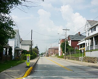
Everson is a borough in Fayette County, Pennsylvania, United States. The population was 768 at the 2020 census. It was incorporated in 1903.

<span class="mw-page-title-main">Fairchance, Pennsylvania</span> Borough in Pennsylvania, United States

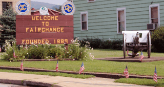
Fairchance is a borough in Fayette County, Pennsylvania, United States. The population was 1,889 at the 2020 census, a decline from the figure of 1,975 tabulated in 2010. It is served by the Albert Gallatin Area School District.

<span class="mw-page-title-main">Markleysburg, Pennsylvania</span> Borough in Pennsylvania, United States

Markleysburg is a borough in Fayette County, Pennsylvania, United States. The population was 246 at the 2020 census. The borough is served by the Uniontown Area School District.

<span class="mw-page-title-main">Masontown, Pennsylvania</span> Borough in Pennsylvania, United States

Masontown is a borough in Fayette County, Pennsylvania, United States. It is part of the Pittsburgh Metro Area. The population of the borough was 3,274 at the 2020 census. It is served by the Albert Gallatin Area School District. Masontown is a small crossroads for the rural portions of western Fayette County, and it contains a small shopping center and a grocery store within its business district.

<span class="mw-page-title-main">Point Marion, Pennsylvania</span> Borough in Pennsylvania, United States

Point Marion is a borough in Fayette County, Pennsylvania, United States. The population was 1,152 at the 2020 census, a decline from the figure of 1,159 tabulated in 2010. It is served by the Albert Gallatin Area School District.

<span class="mw-page-title-main">Smithfield, Pennsylvania</span> Borough in Pennsylvania, United States

Smithfield is a borough in Fayette County, Pennsylvania, United States. The population was 830 at the 2020 census. It is served by the Albert Gallatin Area School District. The town's largest employer is a small wire producing plant run by Nelson Steel.

<span class="mw-page-title-main">Cumberland Township, Greene County, Pennsylvania</span> Township in Pennsylvania, United States

Cumberland Township is a township in Greene County, Pennsylvania, United States. The population was 6,399 at the 2020 census.

<span class="mw-page-title-main">Fairdale, Pennsylvania</span> Census-designated place in Pennsylvania, United States

Fairdale is a community and census-designated place (CDP) in Greene County, Pennsylvania, United States. The population was 2,059 at the 2010 census.

<span class="mw-page-title-main">Franklin Township, Greene County, Pennsylvania</span> Township in Pennsylvania, United States

Franklin Township is a township in Greene County, Pennsylvania, United States. The population was 7,003 at the 2020 census, down from 7,280 at the 2010 census.

<span class="mw-page-title-main">Jefferson, Greene County, Pennsylvania</span> Borough in Pennsylvania, United States

Jefferson is a borough in Greene County, Pennsylvania, United States. The population was 253 at the 2020 census, a decline from the figure of 270 tabulated in 2010. The borough was named after Thomas Jefferson.

<span class="mw-page-title-main">Monongahela Township, Greene County, Pennsylvania</span> Township in Pennsylvania, United States

Monongahela Township is a township in Greene County, Pennsylvania, United States. The population was 1,489 at the 2020 census, down from 1,572 at the 2010 census.

<span class="mw-page-title-main">Nemacolin, Pennsylvania</span> Census-designated place in Pennsylvania, United States

Nemacolin is a census-designated place (CDP) in Greene County, Pennsylvania, United States. It was founded as a company town around the workings of a Youngstown Sheet and Tube Company that owned and operated a coal mine in 1917. The name reflects a noted Amerindian ally Chief Nemacolin, who showed the Virginia and Pennsylvania settlers how to cross the successive Allegheny barrier ridges via the Cumberland Narrows and the Nemacolin Trail—which Braddock's Expedition widened into a wagon road through the mountains. The population of the CDP was 937 at the 2010 census.

<span class="mw-page-title-main">Rices Landing, Pennsylvania</span> Borough in Pennsylvania, United States

Rices Landing is a borough in Greene County, Pennsylvania, United States. The population was 426 at the 2020 census.

<span class="mw-page-title-main">Waynesburg, Pennsylvania</span> Borough in Pennsylvania, United States

Waynesburg is a borough in and the county seat of Greene County, Pennsylvania, United States, about 50 miles (80 km) south of Pittsburgh. Its population was 3,987 at the 2020 census.

<span class="mw-page-title-main">Confluence, Pennsylvania</span> Borough in Pennsylvania, United States

Confluence is a borough in Somerset County, Pennsylvania, United States. It is part of the Johnstown, Pennsylvania, Metropolitan Statistical Area. The population was 724 at the 2020 census.

<span class="mw-page-title-main">Youngsville, Pennsylvania</span> Borough in Pennsylvania, United States

Youngsville is a borough in Warren County, Pennsylvania, United States. The population was 1,729 at the 2010 census.

<span class="mw-page-title-main">Burgettstown, Pennsylvania</span> Borough in Pennsylvania, United States

Burgettstown is a borough in northwestern Washington County, Pennsylvania, United States. The population was 1,424 according to the 2020 census. It is part of the Pittsburgh metropolitan area.

References

  1. "ArcGIS REST Services Directory". United States Census Bureau. Retrieved October 12, 2022.
  2. 1 2 "Census Population API". United States Census Bureau. Retrieved Oct 12, 2022.
  3. 1 2 Bureau, US Census. "City and Town Population Totals: 2020—2021". Census.gov. US Census Bureau. Retrieved July 24, 2022.
  4. 1 2 "Geographic Identifiers: 2010 Demographic Profile Data (G001): Carmichaels borough, Pennsylvania". American Factfinder. U.S. Census Bureau. Retrieved January 27, 2017.[ dead link ]
  5. "National Register Information System". National Register of Historic Places . National Park Service. July 9, 2010.
  6. "US Gazetteer files: 2010, 2000, and 1990". United States Census Bureau. 2011-02-12. Retrieved 2011-04-23.
  7. "Census of Population and Housing". U.S. Census Bureau. Retrieved 11 December 2013.
  8. 1 2 "U.S. Census website". United States Census Bureau . Retrieved 2008-01-31.
  9. "Incorporated Places and Minor Civil Divisions Datasets: Subcounty Resident Population Estimates: April 1, 2010 to July 1, 2012". Population Estimates. U.S. Census Bureau. Archived from the original on 11 June 2013. Retrieved 11 December 2013.
  10. "Census of Population and Housing". Census.gov. Retrieved June 4, 2016.
  11. Walton, Rod. "Kiewit close to completing 625-MW Hill Top CCGT plant in PA". Power Engineering. Retrieved 11 May 2021.
  12. Napsha, Joe. "Natural gas-fueled power plants on rise". Trib Total Media. Retrieved 11 May 2021.