
Goleta is a city in southern Santa Barbara County, California, United States. It was incorporated as a city in 2002, after a long period as the largest unincorporated populated area in the county. As of the 2000 census, the census-designated place had a total population of 55,204. A significant portion of the census territory of 2000 did not incorporate into the new city. The population of Goleta was 32,690 at the 2020 census. It is known for being near the University of California, Santa Barbara, campus.
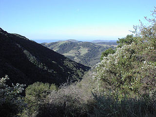
Gaviota State Park is a state park of California, United States. It is located in southern Santa Barbara County, California, about 33 miles (53 km) west of the city of Santa Barbara. One of three state parks along the Gaviota Coast, it extends from the Pacific coast to the crest of the Santa Ynez Mountains, and is adjacent to Los Padres National Forest. The 2,787-acre (1,128 ha) park was established in 1953.

Ballona Creek is an 8.8-mile-long (14.2 km) urbanized river in southwestern Los Angeles County, California that passes Ballona Wetlands Ecological Reserve and empties into Santa Monica Bay. The Ballona Creek watershed includes a portion of the western Los Angeles basin, from the Santa Monica Mountains on the north, the Harbor Freeway (I-110) on the east, and the Baldwin Hills on the south.

State Route 154 is a state highway in the U.S. state of California that runs from Los Olivos to Santa Barbara, crossing the San Marcos Pass in the Santa Ynez Mountains. Before U.S. Route 101 was built through the Gaviota Pass, SR 154 was the main throughway to Santa Barbara and the tri city area including use as a stagecoach route in early years. After being replaced by US 101 as the primary route between the Santa Ynez Valley and Santa Barbara, SR 154 now serves as a scenic bypass.

The Santa Ynez River is one of the largest rivers on the Central Coast of California. It is 92 miles (148 km) long, flowing from east to west through the Santa Ynez Valley, reaching the Pacific Ocean at Surf, near Vandenberg Space Force Base and the city of Lompoc.
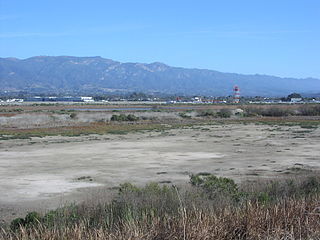
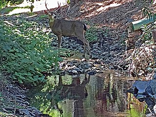
The Goleta Slough is an area of estuary, tidal creeks, tidal marsh, and wetlands near Goleta, California, United States. It primarily consists of the filled and unfilled remnants of the historic inner Goleta Bay about 8 miles (13 km) west of Santa Barbara. The slough empties into the Pacific Ocean through an intermittently closed mouth at Goleta Beach County Park just east of the UCSB campus and Isla Vista. The slough drains the Goleta Valley and watershed, and receives the water of all of the major creeks in the Goleta area including the southern face of the Santa Ynez Mountains.
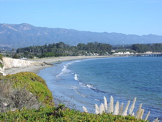
Goleta Beach is a region of coastline located near Goleta, California, just east of the University of California, Santa Barbara (UCSB) campus. A portion of the shore of Goleta Bay is managed by the County of Santa Barbara, as the Goleta Beach County Park (GBCP). The beach itself is partly man-made as sand was spread onto an existing sandspit in 1945. The beach is a seasonal habitat for migrating shorebirds, including the snowy plover, an endangered species, and is occasionally closed due to nourishment efforts.

William Welles Hollister (1818–1886) was a native of Ohio who came west in the 1850s and became a wealthy rancher and entrepreneur in California.

The Stow House is a U.S. historical landmark in Goleta, California. Formerly the headquarters of Rancho La Patera, the Stow House, in the Carpenter Gothic style, is now the headquarters of Goleta Historical Society which preserves and interprets the history of the Goleta Valley.

Novato Creek is a stream in eastern Marin County, California, United States. It originates in highlands between Red Hill and Mount Burdell above the city of Novato, California, and flows 17 miles (27 km) before emptying into San Pablo Bay south of Petaluma Point.

San Diego Creek is a 16-mile (26 km) urban waterway flowing into Upper Newport Bay in Orange County, California in the United States. Its watershed covers 112.2 square miles (291 km2) in parts of eight cities, including Irvine, Tustin, and Costa Mesa. From its headwaters in Laguna Woods the creek flows northwest to its confluence with Peters Canyon Wash, where it turns abruptly southwest towards the bay. Most of the creek has been converted to a concrete flood control channel, but it also provides important aquatic and riparian habitat along its course and its tidal estuary.
Rancho Dos Pueblos was a 15,535-acre (62.87 km2) Mexican land grant in present day Santa Barbara County, California given in 1842 by Governor Juan Alvarado to Nicolas A. Den. The rancho stretched along the Pacific coast to the northwest of today's city of Santa Barbara, from Fairview Avenue in Goleta to the southeastern boundary of today's El Capitan State Beach. A 500-acre parcel was bought by Colin Powys Campbell in 1919. That parcel is now owned by University of California, Santa Barbara which purchased it from the Devereux Foundation in 2007, following the closure of the campus it had established there in 1945.

San Mateo Creek is a stream in Southern California in the United States, whose watershed mostly straddles the border of Orange and San Diego Counties. It is about 22 miles (35 km) long, flowing in a generally southwesterly direction. Draining a broad valley bounded by the Santa Ana Mountains and Santa Margarita Mountains, San Mateo Creek is notable for being one of the last unchannelized streams in Southern California.
Adobe Creek, historically San Antonio Creek, is a 14.2-mile-long (22.9 km) northward-flowing stream originating on Black Mountain in the Santa Cruz Mountains. It courses through the cities of Los Altos Hills, Los Altos, and Palo Alto on its way to the Palo Alto Flood Basin and thence to southwestern San Francisco Bay in Santa Clara County, California, United States. Historically, Adobe Creek was a perennial stream and hosted runs of steelhead trout entering from the Bay, but these salmonids are now blocked by numerous flood control structures, including a tidal gate at the creek's mouth and a long concretized rectangular channel culminating in an impassable drop structure at El Camino Real. The co-founders of Adobe Systems both lived on Adobe Creek.
Permanente Creek is a 13.3-mile-long (21.4 km) stream originating on Black Mountain in Santa Clara County, California, United States. It is the namesake for the Kaiser Permanente health maintenance organization. Named by early Spanish explorers as Arroyo Permanente or Rio Permanente because of its perennial flow, the creek descends the east flank of Black Mountain then courses north through Los Altos and Mountain View culminating in southwest San Francisco Bay historically at the Mountain View Slough but now partly diverted via the Permanente Creek Diversion Channel to Stevens Creek and the Whisman Slough in San Francisco Bay.

Carneros Creek is a westward flowing stream and is the primary source of freshwater flowing into Elkhorn Slough. The Carneros Creek official mainstem is 9.8 miles (15.8 km) long. Its source is in the northern Gabilan Range along Highway 101/156. After it waters transit Elkhorn Slough, the historic mouth of the Salinas River, Carneros Creek empties into Monterey Bay at Moss Landing, California.

Salsipuedes Creek is a 9.9 miles (15.9 km) long stream, flowing north to join the Santa Ynez River just southeast of Lompoc in Santa Barbara County, California. Salsipuedes Creek, along with its major tributary, El Jaro Creek, is the largest tributary to the lower Santa Ynez River, shortly before the river reaches the Pacific Ocean.
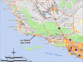
The La Goleta Gas Field is a natural gas field in unincorporated Santa Barbara County, California, adjacent to the city of Goleta. Discovered in 1929, and first put into production in 1932, it has been in continuous use ever since, producing approximately 12 billion cubic feet of gas. With production declining, the field was converted into a gas storage reservoir in 1941. As of 2016 it remains one of the four gas storage facilities maintained by Southern California Gas Company (SoCalGas), a division of Sempra Energy, with the others being Aliso Canyon, Honor Rancho and Playa del Rey. It is the oldest storage facility of the four and the third largest, with a maximum capacity of 21.5 billion cubic feet. The storage facilities are necessary to balance load for the over ten million customers of SoCalGas: during summer months, when gas usage is at a minimum, gas is pumped into the reservoirs; and in the winter when usage is high, gas is withdrawn. The La Goleta field serves the northern portion of SoCalGas's geographic range.
The Gaviota Coast in Santa Barbara County, California is a rural coastline along the Santa Barbara Channel roughly bounded by the city of Goleta and the north boundary of the county. This last undeveloped stretch of Southern California coastline consists of dramatic bluffs, isolated beaches and terraced grasslands.
