Carpentaria, Queensland

Last updated

Map all coordinates using: OpenStreetMap
Carpentaria
Queensland
Cattle beside Savannah Way - panoramio.jpg
Cattle beside the Savannah Way (Burketon to Normanton Road), 2013
Australia Queensland location map.svg
Red pog.svg
Carpentaria
Coordinates 17°58′59″S140°09′36″E / 17.9830°S 140.16°E / -17.9830; 140.16 (Carpentaria (centre of locality))
Population25 (SAL 2021) [1]
Postcode(s) 4823
Area4,730.6 km2 (1,826.5 sq mi)
Time zone AEST (UTC+10:00)
Location
LGA(s) Shire of Carpentaria
State electorate(s) Traeger
Federal division(s) Kennedy
Suburbs around Carpentaria:
Gulf of Carpentaria Gulf of Carpentaria Gulf of Carpentaria
Burketown Carpentaria Normanton
Gregory Stokes Stokes

Carpentaria is a coastal locality in the Shire of Carpentaria, Queensland, Australia. [2] In the 2021 census, Carpentaria had a population of 25 people. [3]

Contents

Geography

Road train on the Burketown Normanton Road, 2013 Another Road Train - panoramio.jpg
Road train on the Burketown Normanton Road, 2013

The locality is on the southern coast of the Gulf of Carpentaria. It is part of the Gulf Country. The Leichhardt River forms the western boundary of the locality ( 17°35′57″S139°47′24″E / 17.5992°S 139.7900°E / -17.5992; 139.7900 (Leichhardt River (mouth)) ). [4]

The coastal strip is mangrove swamps, [5] while the land use in the remainder of the locality is grazing on native vegetation. [4]

Carpentaria has the following coastal features, from west to east:

The north-western corner of the locality (alongside the Leichhardt River) is within the Finucane Island National Park. [13] [4] It is an estuarine wetland which is important for its fish and waterbirds habitats. Its seagrasses are used for grazing by dugongs. It is only accessible by boat and visitors should beware of crocodiles. [14]

The Burketown Normanton Road passes through the locality from the south-east (Normanton) to the south-west (Stokes). [4]

History

The name derives from the Gulf of Carpentaria, a name used on Dutch charts since 1700. [2]

Gore Point was named in July 1841 by Lieutenant John Lort Stokes of HMS Beagle. It was named after Lieutenant Graham Gore who also served on the Beagle. [15] Disaster Inlet was also named by Stokes after Gore's accident with an exploding firearm which wounded Gore in the hand. [9]

In 2015, significant die-back of mangroves occurred due to extremely dry weather conditions lowering the level of the sea water. Climate change is suggested to be the cause. [16]

Demographics

In the 2016 census, Carpentaria had a population of 14 people. [17]

In the 2021 census, Carpentaria had a population of 25 people. [3]

Education

There are no schools in Carpentaria. The nearest government primary schools are in Normanton State School in neighbouring Normanton to the east and Burketon State School in neighbouring Burketown to the west. The nearest government secondary school is Normanton State School to Year 10. However, parts of the locality are too distant from these schools for a daily commute. Also, there are no nearby schools offering secondary schooling to Year 12. Distance education and boarding schools are other options. [4]

Related Research Articles

<span class="mw-page-title-main">Bedourie, Queensland</span> Town in Queensland, Australia

Bedourie is a town and a locality in the Shire of Diamantina, Queensland, Australia. It is on the border with the Northern Territory. In the 2016 census, Bedourie had a population of 122 people.

<span class="mw-page-title-main">Birdsville</span> Town in Queensland, Australia

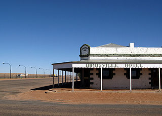
Birdsville is a rural town and locality in the Shire of Diamantina, Queensland, Australia. The locality is on the Queensland border with both the Northern Territory and South Australia. The town is situated 10 kilometres (6 mi) north of the South Australian border. In the 2021 census, the locality of Birdsville had a population of 110 people.

<span class="mw-page-title-main">Normanton, Queensland</span> Town in Queensland, Australia

Normanton is an outback town and coastal locality in the Shire of Carpentaria, Queensland, Australia. At the 2021 census, the locality of Normanton had a population of 1,391 people, and the town of Normanton had a population of 1,326 people.

<span class="mw-page-title-main">Croydon, Queensland</span> Town in Queensland, Australia

Croydon is an outback town and locality within the Shire of Croydon in Queensland, Australia. It is a terminus for the Normanton to Croydon railway line, which operates the Gulflander tourist train. At the 2016 census, Croydon had a population of 258 people.

Doomadgee is a town and a locality in the Aboriginal Shire of Doomadgee, Queensland, Australia. It is a mostly Indigenous community, situated about 140 kilometres (87 mi) from the Northern Territory border, and 93 kilometres (58 mi) west of Burketown.

<span class="mw-page-title-main">Karumba, Queensland</span> Town in Queensland, Australia

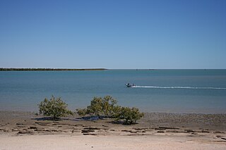
Karumba is a town and a coastal locality in the Shire of Carpentaria, Queensland, Australia. In the 2016 census, the locality of Karumba had a population of 531 people.

<span class="mw-page-title-main">Burketown</span> Town in Queensland, Australia

Burketown is an isolated outback town and coastal locality in the Shire of Burke, Queensland, Australia. In the 2016 census, the locality of Burketown had a population of 238 people.

<span class="mw-page-title-main">Shire of Carpentaria</span> Local government area in Queensland, Australia

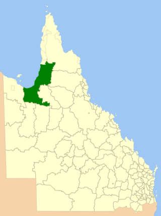
The Shire of Carpentaria is a local government area in Far North Queensland, Australia on the Gulf of Carpentaria, for which it is named.

<span class="mw-page-title-main">Shire of Burke</span> Local government area in Queensland, Australia

The Shire of Burke is a local government area in North West Queensland, Australia. The shire lies on the south coast of the Gulf of Carpentaria and abuts the border with the Northern Territory. It covers an area of 39,864 square kilometres (15,391.6 sq mi), and has existed as a local government entity since 1885. The major town and administrative centre of the shire is Burketown.

<span class="mw-page-title-main">Dululu</span> Town in Queensland, Australia

Dululu is a rural town and locality in the Shire of Banana, Queensland, Australia. In the 2016 census, the locality of Dululu had a population of 126 people.

<span class="mw-page-title-main">Comet, Queensland</span> Town in Queensland, Australia

Comet is a historically-rich rural town and locality in the Central Highlands Region, Queensland, Australia. In the 2016 census, the locality of Comet had a population of 498 people.

<span class="mw-page-title-main">Duchess, Queensland</span> Town in Queensland, Australia

Duchess is a rural town and locality in the Shire of Cloncurry, Queensland, Australia. In the 2016 census, Duchess had a population of 23 people.

Gilberton is a rural locality in the Shire of Etheridge, Queensland, Australia. In the 2016 census, Gilberton had a population of 4 people.

<span class="mw-page-title-main">Four Ways, Queensland</span> Suburb of Shire of Cloncurry, Queensland, Australia

Four Ways is an outback locality in the Shire of Cloncurry, Queensland, Australia. In the 2016 census, Four Ways had a population of 15 people.

<span class="mw-page-title-main">Blackbull, Queensland</span> Suburb of Shire of Croydon, Queensland, Australia

Blackbull is a rural locality in the Shire of Croydon, Queensland, Australia. In the 2016 census Blackbull had a population of 3 people.

<span class="mw-page-title-main">Stokes, Queensland</span> Suburb of Shire of Carpentaria, Queensland, Australia

Stokes is an outback locality in the Shire of Carpentaria, Queensland, Australia. In the 2021 census, Stokes had a population of 75 people.

<span class="mw-page-title-main">Howitt, Queensland</span> Suburb of Shire of Carpentaria, Queensland, Australia

Howitt is a coastal locality in the Shire of Carpentaria, Queensland, Australia. In the 2021 census, Howitt had a population of 48 people.

Fielding is a locality in the Shire of Carpentaria, Queensland, Australia. In the 2016 census, Fielding had a population of 6 people.

Yagoonya is a coastal locality in the Shire of Carpentaria, Queensland, Australia. In the 2016 census, Yagoonya had a population of 25 people.

Gangalidda is a coastal locality in the Aboriginal Shire of Doomadgee, Queensland, Australia, on the Gulf of Carpentaria. In the 2021 census, Gangalidda had "no people or a very low population".

References

  1. Australian Bureau of Statistics (28 June 2022). "Carpentaria (suburb and locality)". Australian Census 2021 QuickStats. Retrieved 28 June 2022.  OOjs UI icon edit-ltr-progressive.svg
  2. 1 2 "Carpentaria – locality in Shire of Carpentaria (entry 42907)". Queensland Place Names. Queensland Government . Retrieved 27 November 2018.
  3. 1 2 Australian Bureau of Statistics (28 June 2022). "Carpentaria (SAL)". 2021 Census QuickStats. Retrieved 28 February 2023. OOjs UI icon edit-ltr-progressive.svg
  4. 1 2 3 4 5 "Queensland Globe". State of Queensland . Retrieved 29 August 2023.
  5. "NESP TWQ Round 4 - Project 4.13 – Assessing the Gulf of Carpentaria mangrove dieback | eAtlas". eatlas.org.au. Archived from the original on 6 June 2023. Retrieved 29 August 2023.
  6. "Leichhardt River – watercourse in the Burke Shire (entry 19176)". Queensland Place Names. Queensland Government . Retrieved 30 August 2023.
  7. 1 2 "Mountain peaks and capes - Queensland". Queensland Open Data. Queensland Government. 12 November 2020. Archived from the original on 25 November 2020. Retrieved 25 November 2020.
  8. "Gore Point – mountain in Carpentaria Shire (entry 14403)". Queensland Place Names. Queensland Government . Retrieved 25 November 2020.
  9. 1 2 "Disaster Inlet – inlet in Shire of Carpentaria (entry 10193)". Queensland Place Names. Queensland Government . Retrieved 29 August 2023.
  10. 1 2 "Bays - Queensland". Queensland Open Data. Queensland Government. 12 November 2020. Archived from the original on 25 November 2020. Retrieved 25 November 2020.
  11. "Middle Point – mountain in Carpentaria Shire (entry 21980)". Queensland Place Names. Queensland Government . Retrieved 25 November 2020.
  12. "Morning Inlet – inlet in Shire of Carpentaria (entry 22840)". Queensland Place Names. Queensland Government . Retrieved 29 August 2023.
  13. "Finucane Island National Park – national park in Burke Shire (entry 51198)". Queensland Place Names. Queensland Government . Retrieved 30 August 2023.
  14. "About | Finucane Island National Park". Parks and forests. Queensland Government. 27 May 2011. Archived from the original on 1 June 2023. Retrieved 29 August 2023.
  15. "Gore Point – point in Shire of Carpentaria (entry 14403)". Queensland Place Names. Queensland Government . Retrieved 29 August 2023.
  16. Duke, Norman (27 July 2022). "Climate change killed 40 million Australian mangroves in 2015. Here's why they'll probably never grow back". The Conversation. Archived from the original on 29 August 2023. Retrieved 29 August 2023.
  17. Australian Bureau of Statistics (27 June 2017). "Carpentaria (SSC)". 2016 Census QuickStats. Retrieved 20 October 2018. OOjs UI icon edit-ltr-progressive.svg

Commons-logo.svg Media related to Carpentaria, Queensland at Wikimedia Commons