Great Falls is a city in and the county seat of Cascade County, Montana, United States. The 2017 census estimate put the population at 58,638. The population was 58,505 at the 2010 census. It is the principal city of the Great Falls, Montana Metropolitan Statistical Area, which encompasses all of Cascade County and has a population of 82,278. Great Falls was the largest city in Montana from 1950 to 1970, when Billings surpassed it. Great Falls remained the second largest city in Montana until 2000, when it was passed by Missoula. Since then Great Falls has been the third largest city in the state.

Bozeman is a city in and the seat of Gallatin County, Montana, United States. Located in southwest Montana, the 2010 census put Bozeman's population at 37,280 and by 2016 the population rose to 45,250, making it the fourth largest city in Montana. It is the principal city of the Bozeman, MT Micropolitan Statistical Area, consisting of all of Gallatin County with a population of 97,304. It is the largest Micropolitan Statistical Area in Montana and is the third largest of all of Montana's statistical areas.

Livingston is a town in and the county seat of Park County, Montana, United States. Livingston is located in southwestern Montana, on the Yellowstone River, north of Yellowstone National Park. The population was 7,044 at the 2010 census.

Deer Lodge is an incorporated city in and the county seat of Powell County, Montana, in the United States. The population was 3,111 at the 2010 census. The city is perhaps best known as the home of the Montana State Prison, a major local employer. The Montana State Hospital in Warm Springs, and former state tuberculosis sanitarium in nearby Galen are the result of the power the western part of the state held over Montana at statehood due to the copper and mineral wealth in that area. Deer Lodge was also once an important railroad town, serving as a division headquarters for the Chicago, Milwaukee, St. Paul and Pacific Railroad before the railroad's local abandonment in 1980.

Butte is the county seat of Silver Bow County, Montana, United States. In 1977, the city and county governments consolidated to form the sole entity of Butte-Silver Bow. The city covers 718 square miles (1,860 km2), and, according to the 2010 census, has a population of approximately 36,400, making it Montana's fifth largest city. It is served by Bert Mooney Airport with airport code BTM.

The Clark Fork, or the Clark Fork of the Columbia River, is a river in the U.S. states of Montana and Idaho, approximately 310 miles (500 km) long. The largest river by volume in Montana, it drains an extensive region of the Rocky Mountains in western Montana and northern Idaho in the watershed of the Columbia River. The river flows northwest through a long valley at the base of the Cabinet Mountains and empties into Lake Pend Oreille in the Idaho Panhandle. The Pend Oreille River in Idaho, Washington, and British Columbia, Canada which drains the lake to the Columbia in Washington, is sometimes included as part of the Clark Fork, giving it a total length of 479 miles (771 km), with a drainage area of 25,820 square miles (66,900 km2). In its upper 20 miles (32 km) in Montana near Butte, it is known as Silver Bow Creek. Interstate 90 follows much of the upper course of the river from Butte to northwest of Missoula. The highest point within the river's watershed is Mount Evans at 10,641 feet (3,243 m) in Deer Lodge County, Montana along the Continental Divide.

Anaconda, county seat of Deer Lodge County, which has a consolidated city-county government, is located in southwestern Montana of the United States. Located at the foot of the Anaconda Range, the Continental Divide passes within 8 mi (13 km) south of the community. As of the 2010 census the population of the consolidated city-county was 9,298, with a per capita personal income of $20,462 and a median household income of $34,716. It had earlier peaks of population in 1930 and 1980, based on the mining industry. It is still the ninth most populous city in Montana. Central Anaconda is 5,335 ft (1,626 m) above sea level, and is surrounded by the communities of Opportunity and West Valley.
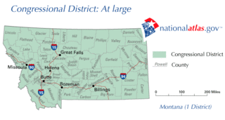
Montana is represented in the United States House of Representatives by one at-large congressional district, among the 435 in the United States Congress. The district is the largest U.S. congressional district by population, with just over 1 million constituents. It is also the second-largest by land area, after Alaska's at-large congressional district.
The Missoulian is a daily newspaper printed in Missoula, Montana. The newspaper has been owned by Lee Enterprises since 1959. The Missoulian is the largest published newspaper in western Montana. The Missoulian is distributed throughout the city of Missoula, Montana, and also throughout most of Western Montana.

Bannack is a ghost town in Beaverhead County, Montana, United States, located on Grasshopper Creek, approximately 11 miles (18 km) upstream from where Grasshopper Creek joins with the Beaverhead River south of Dillon. Founded in 1862, the town contemporarily operates as a National Historic Landmark and is managed by the state of Montana as Bannack State Park.
Bynum is an unincorporated community and census-designated place in Teton County, Montana, United States, about 13 miles north of Choteau. Its population was 31 as of the 2010 census.

Hauser Dam is a hydroelectric straight gravity dam on the Missouri River about 14 miles (23 km) northeast of Helena, Montana, in the United States. The original dam, built between 1905 and 1907, failed in 1908 and caused severe flooding and damage downstream. A second dam was built on the site in 1908 and opened in 1911 and comprises the present structure. The current Hauser Dam is 700 feet (210 m) long and 80 feet (24 m) high. The reservoir formed by the dam, Hauser Lake is 25 miles (40 km) long, has a surface area of 3,800 acres (1,500 ha), and has a storage capacity of 98,000 acre feet (121,000,000 m3) of water when full.
Buffalo is an unincorporated community in Fergus County, Montana, United States. Although it is unincorporated, Buffalo has a post office, with the ZIP code of 59418. It was named for the buffalo which roamed this area.

The following works deal with the cultural, political, economic, military, biographical and geologic history of pre-territorial Montana, Montana Territory and the State of Montana.

The Montana Kaimin is the University of Montana's student-run independent newspaper located in Missoula, Montana. The paper is printed once a week, Wednesday, with special editions printed occasionally. The current editor-in-chief is Matt Neuman. The newspaper is divided into four sections, including news, sports, arts and culture, and opinion, and is printed in color.

Black Eagle Dam is a hydroelectric gravity weir dam located on the Missouri River in the city of Great Falls, Montana. The first dam on the site, built and opened in 1890, was a timber-and-rock crib dam. This structure was the first hydroelectric dam built in Montana and the first built on the Missouri River. The dam helped give the city of Great Falls the nickname "The Electric City." A second dam, built of concrete in 1926 and opened in 1927, replaced the first dam, which was not removed and lies submerged in the reservoir. Almost unchanged since 1926, the dam is 782 feet (238 m) long and 34.5 feet (10.5 m) high, and its powerhouse contains three turbines capable of generating seven megawatts (MW) of power each. The maximum power output of the dam is 18 MW. Montana Power Company built the second dam, PPL Corporation purchased it in 1997 and sold it to NorthWestern Corporation in 2014. The reservoir behind the dam has no official name, but was called the Long Pool for many years. The reservoir is about 2 miles (3.2 km) long, and has a storage capacity of 1,710 acre feet (2,110,000 m3) to 1,820 acre feet (2,240,000 m3) of water.

Black Sandy State Park, located 15 miles (24 km) north of Helena, Montana, in Lewis and Clark County, is a Montana state park on the shores of Hauser Lake, which is formed by Hauser Dam.
This is a Timeline of pre-statehood Montana history comprising substantial events in the history of the area that would become the State of Montana prior to November 8, 1889. This area existed as Montana Territory from May 28, 1864, until November 8, 1889, when it was admitted to the Union as the State of Montana.
The Anzick Site (24PA506) in Park County, Montana, United States, is the only known Clovis burial site in the New World.