Carrickfergus Town Hall

Last updated

Carrickfergus Town Hall
Carrickfergus Town Hall, January 2011 (04).JPG
Carrickfergus Town Hall
LocationJoymount, Carrickfergus
Coordinates 54°42′57″N5°48′19″W / 54.7157°N 5.8053°W / 54.7157; -5.8053
Built1779
ArchitectRichard Drew
Architectural style(s) Georgian style
Listed Building – Grade B+
Official nameCarrickfergus Borough Council Town Hall, Joymount, Carrickfergus, County Antrim
Designated25 February 1976
Reference no.HB 22/08/008
United Kingdom Northern Ireland adm location map.svg
Red pog.svg
Shown in Northern Ireland

Carrickfergus Town Hall is a municipal structure in Joymount in Carrickfergus, County Antrim, Northern Ireland. The town hall, which was the headquarters of Carrickfergus Borough Council, is a Grade B+ listed building. [1]

Contents

History

The former market house in Carrrickfergus, which served as the local council offices until 1935 Former Market House, Carrickfergus (geograph 2383585).jpg
The former market house in Carrrickfergus, which served as the local council offices until 1935

The site selected for the town hall had previously been occupied by a Franciscan friary, which was established in 1248 but disestablished during the Dissolution of the Monasteries in the 1540s. [2] The site was then occupied by a manor house known as Joymount, which was commissioned by the then Lord Deputy of Ireland, Lord Chichester, in 1618. [2] In the 1760s, the Grand Jury of County Antrim, who were based at Castle Worraigh, an ageing stone tower in the middle of the High Street, [3] decided to procure a new courthouse for the county and the old manor house was demolished in 1768 to make way for the new building. [1]

The new building was designed by Richard Drew in the Georgian style, built in brick with white stucco and was completed in 1779. [1] [4] The design involved a symmetrical main frontage with seven bays facing onto the street; the central section of three bays, which slightly projected forward, featured a doorway flanked by Doric order columns supporting an entablature and a pediment with the date of completion in the tympanum. [1] The other bays contained aediculed sash windows and, at roof level, there was a modillioned cornice and, in the middle, a shaped gable containing a clock. [1]

The building served as the venue for some important judicial hearings including the trial of United Irishman, William Orr, for a breach of the Insurrection Act on 14 October 1797; despite extensive evidence of his innocence, he was found guilty and hanged. [5]

The courthouse was extended in 1819: the structure to the north which was accessed through an entrance known as the Hanging Gate was used as a prison. [4] Executions took place at the Hanging Gate: the last person to be hanged there was a soldier, Private John Cordery of the 66th Regiment of Foot, who, at a trial in the courthouse in 1844, was found guilty of murdering a sergeant, who had apparently been bullying him. [6] [7] In the late 19th century the prison was converted for use as a militia barracks. [4]

The borough council, which had previously met in the market house in the Market Place, acquired the courthouse and converted it for use as its town hall in 1935: [8] the interior of the building was remodelled in an Art Deco style at that time. [1] The building continued to serve as the meeting place of the enlarged Carrickfergus Borough Council after it was formed in 1973. [9] During the flag protests in December 2012, angry loyalist protesters disrupted a meeting of the council and threatened councillors. [10] The building ceased to be the local seat of government following the formation of the enlarged Mid and East Antrim Borough Council at Ballymena in April 2015. [11] The exterior of the building was comprehensively redecorated to a scheme designed by Consarc Architects in 2020. [12]

See also

Related Research Articles

<span class="mw-page-title-main">Carrickfergus</span> Town in County Antrim, Northern Ireland

Carrickfergus is a large town in County Antrim, Northern Ireland. It sits on the north shore of Belfast Lough, 11 miles (18 km) from Belfast. The town had a population of 28,141 at the 2021 Census. It is County Antrim's oldest town and one of the oldest towns in Ireland as a whole. Carrickfergus Castle, built in the late 12th century at the behest of Anglo-Norman knight John de Courcy, was the capital of the Earldom of Ulster. After the earldom's collapse, it remained the only English outpost in Ulster for the next four centuries. Carrickfergus was the administrative centre for Carrickfergus Borough Council, before this was amalgamated into the Mid and East Antrim District Council in 2015, and forms part of the Belfast Metropolitan Area. It is also a townland of 65 acres, a civil parish and a barony.

<span class="mw-page-title-main">Larne</span> Town (and civil parish) in County Antrim, Northern Ireland

Larne is a town on the east coast of County Antrim, Northern Ireland, with a population of 18,853 at the 2021 census. It is a major passenger and freight roll-on roll-off port. Larne is administered by Mid and East Antrim Borough Council. Together with parts of the neighbouring districts of Antrim and Newtownabbey and Causeway Coast and Glens, it forms the East Antrim constituency for elections to the Westminster Parliament and Northern Ireland Assembly. The civil parish is in the historic barony of Glenarm Upper.

<span class="mw-page-title-main">Ballyclare</span> Town in County Antrim, Northern Ireland

Ballyclare is a small town in County Antrim, Northern Ireland. It had a population of 9,953 according to the 2011 census, and is located within the Antrim and Newtownabbey Borough Council area.

<span class="mw-page-title-main">Marquess of Donegall</span> Title in the Peerage of Ireland

Marquess of Donegall is a title in the Peerage of Ireland held by the head of the Chichester family, originally from Devon, England. Sir John Chichester sat as a Member of Parliament and was High Sheriff of Devon in 1557. One of his sons, Sir Arthur Chichester, was Lord Deputy of Ireland from 1605 to 1616. In 1613, he was raised to the Peerage of Ireland as Baron Chichester, of Belfast in County Antrim. He died childless in 1625 when the barony became extinct.

<span class="mw-page-title-main">Ballymoney</span> Town in County Antrim, Northern Ireland

Ballymoney is a town and civil parish in County Antrim, Northern Ireland. It is within the Causeway Coast and Glens Borough Council area. The civil parish of Ballymoney is situated in the historic baronies of Dunluce Upper and Kilconway in County Antrim, as well as the barony of North East Liberties of Coleraine in County Londonderry. It had a population of 11,048 people at the 2021 Census.

<span class="mw-page-title-main">Greenisland</span> Human settlement in Northern Ireland

Greenisland is a town in County Antrim, Northern Ireland. It lies 7 miles north-east of Belfast and 3 miles south-west of Carrickfergus. The town is on the coast of Belfast Lough and is named after a tiny islet to the west, the Green Island.

<span class="mw-page-title-main">Whitehead, County Antrim</span> Human settlement in Northern Ireland

Whitehead is a large seaside village on the east coast of County Antrim, Northern Ireland, lying almost midway between the towns of Carrickfergus and Larne. It lies within the civil parish of Templecorran, the historic barony of Belfast Lower, and is part of Mid and East Antrim Borough Council. Before the Plantation of Ulster its name was recorded as both Whitehead and Kinbaine.

<span class="mw-page-title-main">A2 road (Northern Ireland)</span>

The A2 is a major road in Northern Ireland, a considerable length of which is often referred to the Antrim Coast Road because much of it follows the scenic coastline of County Antrim; other parts of the road follow the coasts in Counties Down and Londonderry.

<span class="mw-page-title-main">Glynn, County Antrim</span> Village in County Antrim, Northern Ireland

Glynn is a small village and civil parish in the Mid and East Antrim Borough Council area of County Antrim, Northern Ireland. It lies a short distance south of Larne, on the shore of Larne Lough. As of the 2011 census, the Glynn ward had a population of 2,027 people.

<span class="mw-page-title-main">Charles Lanyon</span>

Sir Charles Lanyon DL, JP was an English architect of the 19th century. His work is most closely associated with Belfast, Northern Ireland.

<span class="mw-page-title-main">Counties of Northern Ireland</span> Former principal local government divisions of Northern Ireland

Northern Ireland is divided into six counties, namely: Antrim, Armagh, Down, Fermanagh, Londonderry and Tyrone. Six largely rural administrative counties based on these were among the eight primary local government areas of Northern Ireland from its 1921 creation until 1973. The other two local government areas were the urban county boroughs of Derry and Belfast.

<span class="mw-page-title-main">Crumlin Road Courthouse</span> Historic site in Crumlin Road, Belfast

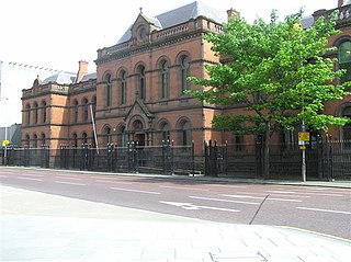
The Crumlin Road Courthouse is a former judicial facility on Crumlin Road in Belfast, Northern Ireland. It is a Grade B+ listed building.

<span class="mw-page-title-main">Mid and East Antrim</span> Local government district in Northern Ireland

Mid and East Antrim is a local government district in Northern Ireland. The district was created on 1 April 2015 by merging the Borough of Ballymena, the Borough of Larne and the Borough of Carrickfergus. The local authority is Mid and East Antrim Borough Council.

<span class="mw-page-title-main">Boneybefore</span> Village in County Antrim, Northern Ireland

Boneybefore is a village near Carrickfergus in County Antrim, Northern Ireland. It lies between the A2 road and Belfast Lough. It is home to the Andrew Jackson Centre, the ancestral home of Andrew Jackson, 7th president of the United States.

<span class="mw-page-title-main">Carrickfergus (barony)</span> Place in Northern Ireland, United Kingdom

Carrickfergus is a barony in County Antrim, Northern Ireland. It is bounded on the south-east by Belfast Lough, and otherwise surrounded by the barony of Belfast Lower. It is coextensive with the civil parish of Carrickfergus or St Nicholas and corresponds to the former county of the town of Carrickfergus, a county corporate encompassing Carrickfergus town.

<span class="mw-page-title-main">Ballymena Town Hall</span> Municipal Building in Ballymena, Northern Ireland

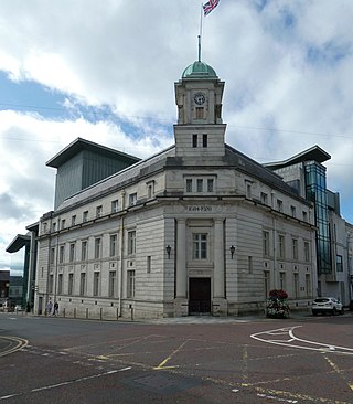
Ballymena Town Hall is a municipal structure in Bridge Street in Ballymena, County Antrim, Northern Ireland. The town hall, which is the headquarters of Mid and East Antrim Borough Council, is a Grade B1 listed building.

<span class="mw-page-title-main">Ballymoney Town Hall</span> Municipal Building in Ballymoney, Northern Ireland

Ballymoney Town Hall is a municipal structure in the High Street, Ballymoney, County Antrim, Northern Ireland. The structure, which incorporates a local history museum, is a Grade B1 listed building.

<span class="mw-page-title-main">Ballyclare Town Hall</span> Municipal Building in Ballyclare, Northern Ireland

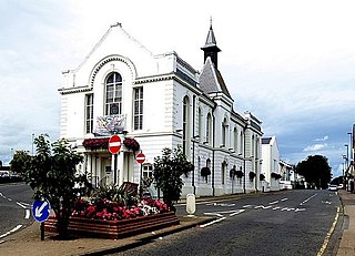
Ballyclare Town Hall is a municipal structure in The Square, Ballyclare, County Antrim, Northern Ireland. The structure, which is primarily used as an events venue, is a Grade B2 listed building.

<span class="mw-page-title-main">Old Town Hall, Belfast</span> Municipal Building in Belfast, Northern Ireland

The Old Town Hall is a municipal structure in Victoria Street, Belfast, Northern Ireland. The structure, which has most recently been used as courthouse, is a Grade B1 listed building.

References

  1. 1 2 3 4 5 6 "Carrickfergus Borough Council Town Hall, Joymount, Carrickfergus, Co. Antrim (HB 22/08/008)". Department for Communities. Retrieved 30 April 2021.
  2. 1 2 "Carrickfergus, County Antrim". Irish Franciscans. Retrieved 30 April 2021.
  3. "Carrickfergus". Vision of Britain. Retrieved 30 April 2021.
  4. 1 2 3 "European Heritage Open Day" (PDF). Department of the Environment. Archived from the original (PDF) on 24 April 2011. Retrieved 9 February 2012.
  5. "William Orr: Speech from the Dock". Library Ireland. Retrieved 30 April 2021.
  6. "Assizes". John Bull. 1844. Retrieved 30 April 2021.
  7. "Carrickfergus Walking Tours: Experience 1,500 years in one day". Mid and East Antrim Council. Retrieved 30 April 2021.
  8. "The Market House". Carrickfergus History. Retrieved 30 April 2021.
  9. "...the Charter of the Corporation of the Borough of Carrickfergus shall have effect in relation to the District of Carrickfergus" "No. 2922". The Belfast Gazette . 7 September 1973. p. 578.
  10. "Trouble flares at flag protests in Belfast". BBC. 18 December 2012. Retrieved 30 April 2021.
  11. "About us". Mid and East Antrim Borough Council. Retrieved 30 April 2021.
  12. "New look for Carrickfergus Town Hall". My News Desk. 18 June 2020. Retrieved 30 April 2021.