
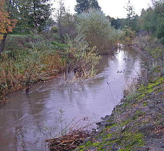
Stevens Creek is a creek in Santa Clara County, California. The creek originates in the Santa Cruz Mountains on the western flank of Black Mountain in the Monte Bello Open Space Preserve near the terminus of Page Mill Road at Skyline Boulevard. It flows southeasterly through the Stevens Creek County Park before turning northeast into Stevens Creek Reservoir. It then continues north for 12.5 miles through Cupertino, Los Altos, Sunnyvale and Mountain View before emptying into the San Francisco Bay at the Whisman Slough, near Google's main campus.

The Petaluma River is a river in the California counties of Sonoma and Marin that becomes a tidal slough for most of its length. The headwaters are in the area southwest of Cotati. The flow is generally southward through Petaluma's old town, where the waterway becomes navigable, and then flows another 10 mi (16 km) through tidal marshes before emptying into the northwest corner of San Pablo Bay.

Putah Creek is a major stream in Northern California, a tributary of the Yolo Bypass, and ultimately, the Sacramento River. The 85-mile-long (137 km) creek has its headwaters in the Mayacamas Mountains, a part of the Coast Range, and flows east through two dams. First, Monticello Dam forms Lake Berryessa, below which Putah Creek forms the border of Yolo and Solano Counties, and then flows to the Putah Diversion Dam and Lake Solano. After several drought years in the late 1980s, the majority of Putah Creek went dry, prompting a landmark lawsuit that resulted in the signing of the Putah Creek Accord in 2000. The Accord established releases from the dams to maintain stream flows in Putah Creek, with natural flow regimes which spike in winter/spring and ebb in summer/fall. The restoration of natural flow regimes has resulted in a doubling of riparian bird species and a return of spawning native steelhead trout and Chinook salmon, as well as protecting the livelihood of farmers on the lower watershed.

Sonoma Creek is a 33.4-mile-long (53.8 km) stream in northern California. It is one of two principal drainages of southern Sonoma County, California, with headwaters rising in the rugged hills of Sugarloaf Ridge State Park and discharging to San Pablo Bay, the northern arm of San Francisco Bay. The watershed drained by Sonoma Creek is roughly equivalent to the wine region of Sonoma Valley, an area of about 170 square miles (440 km2). The State of California has designated the Sonoma Creek watershed as a “Critical Coastal Water Resource”. To the east of this generally rectangular watershed is the Napa River watershed, and to the west are the Petaluma River and Tolay Creek watersheds.
Brush Creek or Rincon Creek is a tributary of Santa Rosa Creek in Sonoma County, California. Brush Creek rises in the southern slopes of the Mayacamas Mountains within Sonoma County. The lower reach of the creek is a suburban medium density residential area in the city of Santa Rosa, and that reach of Brush Creek has been restored during the 1990s under a U.S. Environmental Protection Agency grant to promote steelhead migration and spawning. Further restoration and incorporation into citywide park planning is currently underway as of 2006. The location of the confluence with Santa Rosa Creek is particularly noteworthy, since it was a locus of prehistoric life as a village of the Pomo people and a scenic geologic feature of massive flat boulder outcrops within the stream channel.

Copeland Creek is a 9.0-mile-long (14.5 km) perennial stream that rises on Sonoma Mountain in Sonoma County, California.
Graham Creek is a 2.9-mile-long (4.7 km) perennial stream in Sonoma County, California, tributary to Sonoma Creek. Graham Creek rises in the northern Sonoma Mountains and flows generally northeasterly down the northeastern flank of Sonoma Mountain. Historically this watercourse was called Wild Water Creek, a name used in the time of author Jack London, some of whose work was inspired by the stream. Steelhead, Oncorhynchus mykiss, have historically entered Graham Creek via Sonoma Creek for spawning. Stream surveys conducted from 1966 to 1986 indicated significant, but declining populations of anadromous fish. The spawning habitat of Graham Creek is considered medium to high value, with both winter and summer sheltering characteristics.

San Francisquito Creek is a creek that flows into southwest San Francisco Bay in California, United States. Historically it was called the Arroyo de San Francisco by Juan Bautista de Anza in 1776. San Francisquito Creek courses through the towns of Portola Valley and Woodside, as well as the cities of Menlo Park, Palo Alto, and East Palo Alto. The creek and its Los Trancos Creek tributary define the boundary between San Mateo and Santa Clara counties.

Arroyo Corte Madera del Presidio is a 4.1-mile-long (6.6 km) year-round stream in southern Marin County, California, United States. This watercourse is also known as Corte Madera Creek, although the actual stream of that name flows into San Francisco Bay further north at Point San Quentin. This watercourse has a catchment basin of about 8 square miles (21 km2) and drains the south-eastern slopes of Mount Tamalpais and much of the area in and around the town of Mill Valley; this stream discharges to Richardson Bay.
Calabazas Creek is a 5.5-mile-long (8.9 km) stream in the Sonoma Valley, California, United States, that rises in the southern Mayacamas Mountains and empties into Sonoma Creek near Glen Ellen.
Pilarcitos Creek is a 13.5-mile-long (21.7 km) coastal stream in San Mateo County, California, United States, that rises on the western slopes of the Santa Cruz Mountains and descends through Pilarcitos Canyon to discharge into the Pacific Ocean Half Moon Bay State Beach.

Wildcat Creek is a 13.4-mile-long (21.6 km) creek which flows through Wildcat Canyon situated between the Berkeley Hills and the San Pablo Ridge, emptying into San Pablo Bay in Contra Costa County, northern California.

Maacama Creek is a 7.3-mile-long (11.7 km) stream in northern Sonoma County, California, U.S.A., which empties into the Russian River near the city of Healdsburg.

Atascadero Creek is an 8.8-mile-long (14.2 km) north-flowing stream in Sonoma County, California, United States, which empties into Green Valley Creek.

Adobe Creek is a southward-flowing stream in Sonoma County, California, United States, which flows past the historic Rancho Petaluma Adobe on the creek's 7.5-mile (12.1 km) course to its confluence with the Petaluma River. It has also been called Casa Grande Creek.

Lichau Creek is an 8.9-mile-long (14.3 km) southwest-flowing stream in Sonoma County, California, United States, which flows through the town of Penngrove and discharges into the Petaluma River.

Miller Creek is a 7.6-mile-long (12.2 km) stream in eastern Marin County, California, United States. It originates on Big Rock Ridge and empties into San Pablo Bay east of Marinwood. A middle school called Miller Creek Middle School was named after the creek and is home to 6th, 7th, and 8th graders.

Dutch Bill Creek is a 6.5-mile-long (10.5 km) north-flowing stream in the hills of western Sonoma County, California, which empties into the Russian River at Monte Rio about 7 miles (11 km) from the Pacific Ocean.
Adobe Creek, historically San Antonio Creek, is a 14.2-mile-long (22.9 km) northward-flowing stream originating on Black Mountain in the Santa Cruz Mountains. It courses through the cities of Los Altos Hills, Los Altos, and Palo Alto on its way to the Palo Alto Flood Basin and thence to southwestern San Francisco Bay in Santa Clara County, California, United States. Historically, Adobe Creek was a perennial stream and hosted runs of steelhead trout entering from the Bay, but these salmonids are now blocked by numerous flood control structures, including a tidal gate at the creek's mouth and a long concretized rectangular channel culminating in an impassable drop structure at El Camino Real. The co-founders of Adobe Systems both lived on Adobe Creek.
Permanente Creek is a 13.3-mile-long (21.4 km) stream originating on Black Mountain in Santa Clara County, California, United States. It is the namesake for the Kaiser Permanente health maintenance organization. Named by early Spanish explorers as Arroyo Permanente or Rio Permanente because of its perennial flow, the creek descends the east flank of Black Mountain then courses north through Los Altos and Mountain View culminating in southwest San Francisco Bay historically at the Mountain View Slough but now partly diverted via the Permanente Creek Diversion Channel to Stevens Creek and the Whisman Slough in San Francisco Bay.
