Related Research Articles

The Ogallala Aquifer is a shallow water table aquifer surrounded by sand, silt, clay, and gravel located beneath the Great Plains in the United States. As one of the world's largest aquifers, it underlies an area of approximately 174,000 sq mi (450,000 km2) in portions of eight states. It was named in 1898 by geologist N. H. Darton from its type locality near the town of Ogallala, Nebraska. The aquifer is part of the High Plains Aquifer System, and resides in the Ogallala Formation, which is the principal geologic unit underlying 80% of the High Plains.

Oil sands, tar sands, crude bitumen, or bituminous sands, are a type of unconventional petroleum deposit. Oil sands are either loose sands or partially consolidated sandstone containing a naturally occurring mixture of sand, clay, and water, soaked with bitumen, a dense and extremely viscous form of petroleum.
The Athabasca oil sands, also known as the Athabasca tar sands, are large deposits of bitumen, a heavy and viscous form of petroleum, located in northeastern Alberta, Canada. These reserves are one of the largest sources of unconventional oil in the world, making Canada a significant player in the global energy market.

The Carrizo Plain is a large enclosed grassland plain, approximately 50 miles (80 km) long and up to 15 miles (24 km) across, in southeastern San Luis Obispo County, California, United States, about 100 miles (160 km) northwest of Los Angeles. The southern portion of the Carrizo Plain is within the 246,812-acre (99,881 ha) Carrizo Plain National Monument, which also includes most of the Caliente Range. The Carrizo Plain is the largest single native grassland remaining in California. It includes Painted Rock in the Carrizo Plain Rock Art Discontiguous District, which is listed on the National Register of Historic Places. In 2012 it was further designated a National Historic Landmark due to its archeological value. The San Andreas Fault occurs along the eastern edge of the Carrizo Plain at the western base of the Temblor Range.

The Barnett Shale is a geological formation located in the Bend Arch-Fort Worth Basin. It consists of sedimentary rocks dating from the Mississippian period in Texas. The formation underlies the city of Fort Worth and underlies 5,000 mi2 (13,000 km2) and at least 17 counties.

The Edwards Aquifer is one of the most prolific artesian aquifers in the world. Located on the eastern edge of the Edwards Plateau in the U.S. state of Texas, it is the source of drinking water for two million people, and is the primary water supply for agriculture and industry in the aquifer's region. Additionally, the Edwards Aquifer feeds the Comal and San Marcos Springs, provides springflow for recreational and downstream uses in the Nueces, San Antonio, Guadalupe, and San Marcos river basins, and is home to several unique and endangered species.
Heavy crude oil is highly viscous oil that cannot easily flow from production wells under normal reservoir conditions.
Kicaster Creek is a short stream in Wilson County, Texas. The creek begins in the recharge zone for the Carrizo-Wilcox Aquifer, near Kicaster, six miles southwest of the town of La Vernia. It flows through the Sand Hills Region of Wilson County for eleven miles southeastward to its mouth three miles northwest of the town of Floresville on the San Antonio River.
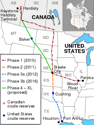
The Keystone Pipeline System is an oil pipeline system in Canada and the United States, commissioned in 2010 and owned by TC Energy and, as of March 2020, the Government of Alberta. It runs from the Western Canadian Sedimentary Basin in Alberta to refineries in Illinois and Texas, and also to oil tank farms and an oil pipeline distribution center in Cushing, Oklahoma.

The Portland Montreal Pipeline is a series of underground crude oil pipelines connecting South Portland, Maine, in the United States with Montreal, Quebec, in Canada. As of early 2016, the pipeline transports limited volumes, sufficient to keep the pipeline wet. The pipeline also supplied crude oil to the Suncor Montreal-Est refinery during supply interruptions due to the 2016 Fort McMurray wildfires.
Environmental issues in Canada include impacts of climate change, air and water pollution, mining, logging, and the degradation of natural habitats. As one of the world's significant emitters of greenhouse gasses, Canada has the potential to make contributions to curbing climate change with its environmental policies and conservation efforts.
Aquifer storage and recovery (ASR) is the direct injection of surface water supplies such as potable water, reclaimed water, or river water into an aquifer for later recovery and use. The injection and extraction is often done by means of a well. In areas where the rainwater cannot percolate the soil or where it is not capable of percolating it fast enough and where the rainwater is thus diverted to rivers, rainwater ASR could help to keep the rainwater within an area. ASR is used for municipal, industrial and agricultural purposes.
350.org is an international environmental organization addressing the climate crisis. Its stated goal is to end the use of fossil fuels and transition to renewable energy by building a global, grassroots movement.
RAVEN (Respecting Aboriginal Values and Environmental Needs) is a charitable organization that provides financial resources to assist Aboriginal nations within Canada in lawfully forcing industrial development to be reconciled with their traditional ways of life, and in a manner that addresses climate change and other ecological sustainability challenges.

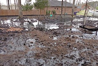
The Kalamazoo River oil spill occurred in July 2010 when a pipeline operated by Enbridge burst and flowed into Talmadge Creek, a tributary of the Kalamazoo River near Marshall, Michigan. A 6-foot (1.8 m) break in the pipeline resulted in one of the largest inland oil spills in U.S. history. The pipeline carries diluted bitumen (dilbit), a heavy crude oil from Canada's Athabasca oil sands to the United States. Cleanup took five years. Following the spill, the volatile hydrocarbon diluents evaporated, leaving the heavier bitumen to sink in the water column. Thirty-five miles (56 km) of the Kalamazoo River were closed for clean-up until June 2012, when portions of the river were re-opened. On March 14, 2013, the Environmental Protection Agency (EPA) ordered Enbridge to return to dredge portions of the river to remove submerged oil and oil-contaminated sediment.

Tar Sands Blockade is a grassroots coalition of affected Texas and Oklahoma people and climate justice organizers who use peaceful and sustained civil disobedience to stop the Keystone XL tar sands pipeline. Tar Sands Blockade used nonviolent direct action to stop construction of the pipeline throughout East Texas including banner drops, lockdowns, and tree sits. They are best known for a large scale tree sit outside Winnsboro, Texas.
Western Canadian Select (WCS) is a heavy sour blend of crude oil that is one of North America's largest heavy crude oil streams and, historically, its cheapest. It was established in December 2004 as a new heavy oil stream by EnCana, Canadian Natural Resources, Petro-Canada and Talisman Energy. It is composed mostly of bitumen blended with sweet synthetic and condensate diluents and 21 existing streams of both conventional and unconventional Alberta heavy crude oils at the large Husky Midstream General Partnership terminal in Hardisty, Alberta. Western Canadian Select—the benchmark for heavy, acidic crudes—is one of many petroleum products from the Western Canadian Sedimentary Basin oil sands. Calgary-based Husky Energy, now a subsidiary of Cenovus, had joined the initial four founders in 2015.
The 2013 Mayflower oil spill occurred on March 29, 2013, when the Pegasus Pipeline, owned by ExxonMobil and carrying Canadian Wabasca heavy crude from the Athabasca oil sands, ruptured in Mayflower, Arkansas, about 25 miles (40 km) northwest of Little Rock releasing about 3,190 barrels of oil. Approximately 3,190 barrels of oil and water mix was recovered. Twenty-two homes were evacuated. The United States Environmental Protection Agency (EPA) classified the leak as a major spill.
The Sandow Lakes Ranch is a 33,800-acre ranch in Texas, U.S. It spans three counties, including Milam County, Texas, There are 14 lakes on the ranch and "48,379 acre feet of water" from the Carrizo-Wilcox Aquifer. It was acquired by Alcoa in the 1950s. In 2016, Alcoa listed it for US$250 million.

Unconventional reservoirs, or unconventional resources are accumulations where oil and gas phases are tightly bound to the rock fabric by strong capillary forces, requiring specialised measures for evaluation and extraction.
References
- ↑ "Carrizo-Wilcox Aquifer". Texas Water Development Board. Retrieved July 6, 2016.
- 1 2 Mitchell, Kenny (2012-07-24). "Tar Sands in the Basin: Politics and Protests". The New York Times . Retrieved 2012-11-12.
| | This Texas state location article is a stub. You can help Wikipedia by expanding it. |
| | This water supply–related article is a stub. You can help Wikipedia by expanding it. |