| Carta marina et descriptio septentrionalium terrarium (Latin) English: Marine map and description of the Northern lands | |
|---|---|
 Composite from 1949 facsimile |
Carta marina et descriptio septentrionalium terrarum (Latin for Marine map and description of the Northern lands; [1] commonly abbreviated Carta marina) is the first map of the Nordic countries to give details and place names, created by Swedish ecclesiastic Olaus Magnus and initially published in 1539. Only two earlier maps of the Nordic countries are known, those of Jacob Ziegler (Strasbourg, 1532) and Claudius Clavus (15th century).
Contents
- History
- Surviving copies
- Adaptations
- See also
- Notes
- References
- External links
- Digital copies of the first known 'München' original
- Digital copies of the second known 'Uppsala' original
- Digital copies of modifications and adaptations
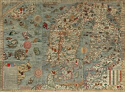
The map is centred on Scandia, which is shown in the largest size text on the map and placed on the middle of Sweden. The map covers the Nordic lands of "Svecia" (Svealand) and "Gothia" (Götaland) (both areas in Sweden), "Norvegia" (Norway), Dania (Denmark), "Fare" (Faroe Islands), Islandia (Iceland), Finlandia (Finland), Lituania (Lithuania), Livonia (Estonia and Latvia), and "pars" (parts of) "Scotie" (Scotland; including Orkney and Shetland) and "Anglie" (England). The map is framed with longitudes and latitudes running from 55° to the Arctic Circle. [2] The sea is filled with numerous animals, many recognisable, including various whales and walrus. [3]
The map is 1.70 m wide by 1.25 m tall, and was printed in black and white from nine 55 × 40 cm woodcut blocks sequenced from west to east and north to south, and identified in the centre with the letters A to I. [4]

