Cartography of New Zealand

Last updated

Thevenot - Hollandia Nova detecta 1644.png
Vincenzo Coronelli00.jpg
First map of New Zealand 1644 and Map of the Pacific Ocean, showing the fictitious great southern continent 1690.
Cook chart of New Zealand.jpg
New Zealand Topography.jpg
Map of New Zealand by James Cook 1770, next to the modern version.
Sketch of Dusky Bay in New Zealand; 1773. RMG F0045.tiff
Plan of the town and part of the settlement of New Plymouth, New Zealand, selected surveyed and delineated by Fred. A.Carrington; late Chief Surveyor of the settlement. RMG F0149.tiff
Sketch of Dusky Sound in New Zealand 1773 and plan of the town and part of the settlement of New Plymouth 1850.

The cartography of New Zealand is the history of surveying and creation of maps of New Zealand. Surveying in New Zealand began with the arrival of Abel Tasman in the mid 17th century. [1] Cartography and surveying have developed in incremental steps since that time till the integration of New Zealand into a global system based on GPS and the New Zealand Geodetic Datum 2000. [2]

Contents

Initially surveys were done by measuring points on the ground and staking out areas, this was quickly followed in the late 1800s by the triangulation method. The New Zealand Institute of Surveyors was established in 1888 after an earlier attempt in 1881. The government then divided the country into 28 'Meridional Circuits' each of which had a known point that other locations could be measured from. The Circuits were further divided into Survey Districts. [3] [4] This system worked well except for surveys that needed to work across neighboring Circuits. To solve this problem the geodetic triangulation of the whole country was performed between 1909 and 1947. This was used for the Geodetic Datum 1949 and New Zealand Map Grid. [5] [2] This was followed by the use of aerial photography, orthophotos and finally satellite photos. [6] Later the New Zealand Geodetic Datum 2000 superseded the 1949 version, and the bespoke NZMG projection was replaced by New Zealand Transverse Mercator 2000. [2] New Zealand topographical maps are sold digitally and in 1:50,000 and 1:250,000 printed versions. [7]

History

Prior to European colonisation, New Zealand was divided into territories of tribes (Iwi) and subtribes (hapu). Boundaries were defined by landmarks which were remembered in chants and oral tradition. [8] [9] The ownership of natural resources was often more important than the land they were on. [10] Land was held by customary possession, gifted, or by conquest and occupation. [8]

Māori had no map-making tradition. Early Polynesian explorers did, however, made stick diagrams to represent the distance and direction to islands. [11] When the early European explorers arrived in New Zealand many of the geographical features had already been named. [12]

Early explorers

The first two European expeditions to map New Zealand (Abel Tasman and James Cook) were both trying to find the hypothesized continent of Terra Australis. They also gave New Zealand its first non Māori place names. [13] This period of time brought about the first maps drawn by Māori. These ranged from local representations in sand to detailed sketches of the whole South Island. [14]

Cook proved the absence of Terra Australis and made detailed maps of New Zealand. [13] These maps contained two significant errors, showing Stewart Island as a peninsula and Banks Peninsula as an island. [15] The French explorer Dumont d’Urville would quickly correct the later of these claims. [13] [16] The first detailed maps and reports of abundant wildlife brought sealers then whales to New Zealand. [17] Sales of land to European colonists prior to 1840 were not regulated. Disputes arose mainly in areas where tribal possession was unclear.

After the Treaty of Waitangi

Following the Treaty of Waitangi in 1840, all lands of New Zealand came under the dominion of the British crown. The treaty allowed the tribes possession of their customary lands. Europeans wanting to purchase land negotiated through a government commission. If negotiations were successful, the applicant was given a crown grant that gave them ownership under British law. The purchases prior to 1840 were known as old land claims and required to go through the same process. Many of these claims were reduced in size from the original agreements. [18]

Various British schemas for colonization were created and maps created to demarcate the land and attract investment. Also at this time Māori and Europeans were negotiating the sale of land. [19] With the start of the Otago Gold Rush and discovery of the Nelson Mineral Belt geologists and surveyor were hired to map inland New Zealand. [1] [20] By 1855 the Acheron and Pandora had mapped New Zealand's coast line in great detail. [21]

The position of surveyor-general was created in the royal instructions of 1840. The first regulations for surveying were established in 1842, when surveyors were required to deposit their licenses with the surveyor general's office to be returned upon completion of a survey. In 1852, provinces were established and each established a survey department. These were often underfunded and most failed to systemise surveys in their territory, making boundaries unreliable because of gaps and overlaps between abutting surveys. Some small triangulation networks were established, and some cities established survey control points on routes known as standard traverses that surveyors could use as a basis for local surveys. In Otago, true north was determined at six points throughout the province. Local surveys could be linked to these points so that their angle measurements were consistent throughout the district. The districts were known as meridional circuits, a term that has persisted in New Zealand surveying. [18]

In 1875 Major H S Palmer of the Ordnance Survey of Great Britain presented a damning report on the state of the survey system to the New Zealand Parliament. He recommended that a unified map projection was adopted and a single system of reference points was established across the country. In 1876, the provinces were abolished and the survey departments were combined. [22] The chief surveyor of the Otago province, John Turnbull Thomson, was made surveyor-general of the new government survey department. Thompson established meridional circuits throughout the country as well as reorganising the way land records were identified and recorded. By 1880, the small original triangulation networks had been extended and joined throughout New Zealand. [18]

Geodetic surveys

In the years following Major Palmer's report, triangulation had been extended throughout New Zealand, but accuracy had been found wanting. It was not until 1921 that Surveyor-General W.T. Neill began work on a system that would create accurate reference points throughout New Zealand. In 1923, the first baseline was measured near Kaingaroa. From 1930 onward, observations were made at night to improve accuracy. The longest observation was 120 kilometres (75 mi) across Cook Strait. Work continued through World War II as the project was allowed topographical maps for military use to be quickly compiled. The last fieldwork was completed in early 1949, and the system became known as the New Zealand Geodetic Datum 1949. [18]

The 1949 datum was updated in 2000. To ease GPS measurement the new system was slightly shifted to become geocentric (the origin point of the system coincides with the centre of the Earth). It was also designed to be semi-dynamic, to cope better with seismic movement. This system is called the New Zealand Geodetic Datum 2000, and includes the NZ Transverse Mercator projection that topographical maps are published in. [23]

These geodetic activities are responsible for the ubiquitous trig stations that reside mostly at the top of many hills throughout New Zealand.

Queen's Chain

The "Queen's Chain" is a concept in New Zealand property law. It is a strip of public land, usually 20 metres (or one chain in pre-metric measure) wide along rivers, lakes and the coast line. It was designed to prevent land upriver or along a coast being inaccessible to any prospective buyers. The strips are incomplete and their exact modern location can be complex to determine. [24] [25] These strips exist in various forms (including road reserves, esplanade reserves, esplanade strips, marginal strips and reserves of various types) but not as extensively and consistently as is often assumed. [26]

Current system

A volcanologist takes theodolite measurements on the crater lake of Mt Ruapehu. Theodolite measurement on Ruapehu volcano.jpg
A volcanologist takes theodolite measurements on the crater lake of Mt Ruapehu.
Trig station on top of Mount Maunganui Mount Maunganui triangulation station.jpg
Trig station on top of Mount Maunganui

Cadastral surveying in New Zealand is governed by the Cadastral Survey Act 2002, which defines legal bodies that deal with aspects of the profession. The act devolves power to create specific regulations to the surveyor-general, who periodically issues the surveyor-general's rules for cadastral surveys. The Land Transfer Act 1952 also influences the way surveys are done.

The Torrens system of land registration was introduced in the Land Transfer Act 1870. The act introduced a system where land title is held in a register as opposed to the previous system that registered the document containing the title information. It therefore made it unnecessary to search the history of a title, and made titles indefeasible, meaning that it cannot be claimed by persons other than the registered owner.

A separate system exists in parallel with the general land titles for land held in common by Māori as a tribe. This is controlled by the Te ture Whenua Maori (Maori Land) Act 1993. In 1980, 4.5% of New Zealand land was held in the Māori land system. [8] This does not include land held by Māori individuals in the general land system.

A surveyor who has fulfilled the requirements to legally sign subdivision plans is known as a licensed cadastral surveyor.

Construction surveying is not regulated at the state level in New Zealand. However, matters relating to surveying may require certification by a registered professional surveyor under contract law or local authority regulations.

Surveying in New Zealand uses whole circle (azimuth) bearings. Another oddity is the convention of writing coordinates where the northing is written before the easting, at odds with much of the rest of the world.

See also

Related Research Articles

<span class="mw-page-title-main">Māori culture</span> Practices and beliefs of the Māori people of New Zealand

Māori culture is the customs, cultural practices, and beliefs of the indigenous Māori people of New Zealand. It originated from, and is still part of, Eastern Polynesian culture. Māori culture forms a distinctive part of New Zealand culture and, due to a large diaspora and the incorporation of Māori motifs into popular culture, it is found throughout the world. Within Māoridom, and to a lesser extent throughout New Zealand as a whole, the word Māoritanga is often used as an approximate synonym for Māori culture, the Māori-language suffix -tanga being roughly equivalent to the qualitative noun-ending -ness in English. Māoritanga has also been translated as "[a] Māori way of life." The term kaupapa, meaning the guiding beliefs and principles which act as a base or foundation for behaviour, is also widely used to refer to Māori cultural values.

<span class="mw-page-title-main">Lake Wānaka</span> Lake in Otago, New Zealand

Lake Wānaka is New Zealand's fourth-largest lake and the seat of the town of Wānaka in the Otago region. The lake is 278 meters above sea level, covers 192 km2 (74 sq mi), and is more than 300 m (980 ft) deep.

<span class="mw-page-title-main">Miramar Peninsula</span> Land in Wellington city, New Zealand

Te Motu Kairangi / Miramar Peninsula is a large peninsula on the southeastern side of the city of Wellington, New Zealand. It is located at the entrance to Wellington Harbour, in Wellington's eastern suburbs. According to Māori legend, it was formed when the taniwha Whaitaitai beached as he tried to escape the confines of the harbour. It contains the suburb of Miramar.

<span class="mw-page-title-main">Christchurch Girls' High School</span> School in Christchurch, New Zealand

Christchurch Girls' High School in Christchurch, New Zealand, was established in 1877 and is the second oldest girls-only secondary school in the country, after Otago Girls' High School.

<span class="mw-page-title-main">History of the Dunedin urban area</span> Aspect of history of city of Dunedin, New Zealand

The villages and then city that lay at the head of Otago Harbor never existed in isolation, but have always been a staging ground between inland Otago and the wider world. While Dunedin's current official city limits extend north to Waikouaiti, inland to Middlemarch and south to the Taieri River mouth, this articles focus is the history of the Dunedin urban area, only mentioning Mosgiel, the Otago Peninsula, Port Chalmers and inland Otago for context.

In Māori tradition, Kahutara was one of the great ocean-going, voyaging canoes that was used in the migrations that settled New Zealand.

<span class="mw-page-title-main">Whakairo</span> Traditional Māori form of art carving

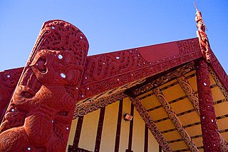
Toi whakairo or just whakairo (carving) is a Māori traditional art of carving in wood, stone or bone.

<span class="mw-page-title-main">French New Zealanders</span>

French New Zealanders are New Zealanders who are of French ancestors or a French-born person who resides in New Zealand.

The New Zealand Open is a darts tournament organized by the New Zealand Darts Council that has been held since 1981.

<span class="mw-page-title-main">Golden Bay / Mohua</span> Bay in New Zealand

Golden Bay is a large shallow bay in New Zealand's Tasman District, near the northern tip of the South Island. An arm of the Tasman Sea, the bay lies northwest of Tasman Bay and Cook Strait. It is protected in the north by Farewell Spit, a 26 km long arm of fine golden sand that is the country's longest sandspit. The Aorere and Tākaka rivers are the major waterways to flow into the bay from the south and the west.

<span class="mw-page-title-main">Whangārei Harbour</span> Place in New Zealand

Whangārei Harbour is a large harbour on the east coast of the North Island of New Zealand.

<span class="mw-page-title-main">Southland Region</span> Region of New Zealand

Southland is New Zealand's southernmost region. It consists mainly of the southwestern portion of the South Island and Stewart Island/Rakiura. It includes Southland District, Gore District and the city of Invercargill. Murihiku Southland is bordered by the culturally similar Otago to the north and east, and the West Coast in the extreme northwest. The region covers over 3.1 million hectares and spans 3,613 km of coast. As of June 2023, Southland has a population of 103,900, making it the eleventh-most-populous New Zealand region, and the second-most sparsely populated.

Japanese New Zealanders are New Zealand citizens of Japanese ancestry, which may include Japanese immigrants and descendants born in New Zealand. Japanese people first began immigrating to New Zealand in the 1890s. Until 1920, 14 Japanese citizens resided in New Zealand. Japanese immigration was halted during the period of the Pacific War and recommenced around the 1950s. From this period onwards, Japanese immigration remained small until the 1990s. In 1997, Japanese peoples were the 19th-largest ethnic group in New Zealand. As of the 2018 census, 18,141 New Zealand residents identify themselves as Japanese New Zealanders.

The Domett Ministry was a responsible government which held power in New Zealand from August 1862 to October 1863. Although Alfred Domett was the head of the government, he was never appointed Premier as that office had yet to be established. Instead, he was Colonial Secretary and Secretary for Crown Lands.

<span class="mw-page-title-main">Housing in New Zealand</span> Overview of housing in New Zealand

Housing in New Zealand was traditionally based on the quarter-acre block, detached suburban home, but many historical exceptions and alternative modern trends exist. New Zealand has largely followed international designs. From the time of organised European colonisation in the mid-19th century there has been a general chronological development in the types of homes built in New Zealand, and examples of each generation are still commonly occupied.

<span class="mw-page-title-main">Mental health in New Zealand</span> Mental health in New Zealand

Mental health in New Zealand generally follows the trends of mental health in other OECD countries. New Zealand's 'outdoor life style' and high standard of living are balanced by isolation and a self-reliant culture, which discourages asking for help. Historically, people with mental health problems were institutionalised, whereas now the focus is on care in the wider community. The stigma around poor mental health has been lessened in recent years as a result of this change and public education campaigns. However, New Zealand's minorities and youth continue to be over-represented in the negative mental health statistics.

The Third Fox Ministry was a responsible government which held power in New Zealand from June 1869 to September 1872. Although William Fox was the head of the government, he was never appointed Premier as that office had yet to be established, although he did resign the office at the end of his tenure. The Ministry was also known as the Fox-Vogel Ministry as most of the agenda was set by the Treasurer, while Fox busied himself with administrative affairs and moral crusades such as the attempted introduction of local option polls for liquor licensing.

The First Vogel Ministry was a responsible government which held power in New Zealand from April 1873 to July 1875.

Manufacturing in New Zealand contributed $23 billion (12%) of the country's gross domestic product and directly employed 241,000 people in 2017, while manufactured goods made up 52% of the country's exports by value. The food and beverage subsector alone contributed 32% of manufacturing's GDP and 71% of exports.

References

  1. 1 2 Maling 1996, pp. 18.
  2. 1 2 3 "New Zealand Transverse Mercator 2000 (NZTM2000) | Land Information New Zealand". LINZ. Retrieved 1 February 2019.
  3. "Land registration, Glossary LINZ". www.linz.govt.nz. 2018.
  4. Taonga, New Zealand Ministry for Culture and Heritage Te Manatu. "1. – Modern mapping and surveying – Te Ara Encyclopedia of New Zealand". teara.govt.nz. Retrieved 6 February 2019.
  5. Taonga, New Zealand Ministry for Culture and Heritage Te Manatu. "2. – Modern mapping and surveying – Te Ara Encyclopedia of New Zealand". teara.govt.nz. Retrieved 6 February 2019.
  6. Taonga, New Zealand Ministry for Culture and Heritage Te Manatu. "6. – Modern mapping and surveying – Te Ara Encyclopedia of New Zealand". teara.govt.nz. Retrieved 6 February 2019.[ permanent dead link ]
  7. "LINZ topographic-maps". www.linz.govt.nz. 2018.
  8. 1 2 3 Winmill, R.H. (1997). "12 - Maori Land Surveys". In Baldwin, J. (ed.). Law For Surveyors. New Zealand Institute Of Surveyors/University Of Otago.
  9. Taonui, Rāwiri (2006). "16 Ngāpuhi". In Phillips, Jock (ed.). Māori peoples of New Zealand = Ngā iwi o Aotearoa (repr. ed.). Auckland: D. Bateman. pp. 111–112. ISBN   978-1-86953-622-0. Contains an example of a chant describing an Iwi's lands.
  10. West, Jonathan (2018). The Face of Nature: An Environmental History of the Otago Peninsula. Otago University Press. ISBN   9781927322383.
  11. Maling 1996, pp. 128.
  12. Taonga, New Zealand Ministry for Culture and Heritage Te Manatu. "3. – Tapa whenua – naming places – Te Ara Encyclopedia of New Zealand". teara.govt.nz. Retrieved 6 February 2019.
  13. 1 2 3 Taonga, New Zealand Ministry for Culture and Heritage Te Manatu. "1. – Early mapping – Te Ara Encyclopedia of New Zealand". teara.govt.nz. Retrieved 6 February 2019.
  14. Maling 1996, pp. 128–131.
  15. Taonga, New Zealand Ministry for Culture and Heritage Te Manatu. "Cook's map of New Zealand". teara.govt.nz. Retrieved 6 February 2019.
  16. Taonga, New Zealand Ministry for Culture and Heritage Te Manatu. "2. – Early mapping – Te Ara Encyclopedia of New Zealand". teara.govt.nz. Retrieved 6 February 2019.
  17. Taonga, New Zealand Ministry for Culture and Heritage Te Manatu. "3. – Early mapping – Te Ara Encyclopedia of New Zealand". teara.govt.nz. Retrieved 6 February 2019.[ permanent dead link ]
  18. 1 2 3 4 Lee, L.P.; Adam, R.S. (1997). "4 - History of the New Zealand Survey System". In Baldwin, J. (ed.). Law For Surveyors. New Zealand Institute Of Surveyors/University Of Otago.
  19. Taonga, New Zealand Ministry for Culture and Heritage Te Manatu. "4. – Early mapping – Te Ara Encyclopedia of New Zealand". teara.govt.nz. Retrieved 6 February 2019.
  20. Taonga, New Zealand Ministry for Culture and Heritage Te Manatu. "Geological exploration – Te Ara Encyclopedia of New Zealand". teara.govt.nz. Retrieved 6 February 2019.
  21. Taonga, New Zealand Ministry for Culture and Heritage Te Manatu. "5. – Early mapping – Te Ara Encyclopedia of New Zealand". teara.govt.nz. Retrieved 6 February 2019.
  22. "LINZ/Our organization/Our Whakapapa". Land Information New Zealand. Retrieved 16 September 2015.
  23. Jones, A; Blick, G. "Where In The World Are We" (PDF). Land Information New Zealand. Retrieved 13 October 2015.
  24. "Queen's Chain". Oxford Dictionaries – oxforddictionaries.com. Archived from the original on 8 August 2018. Retrieved 4 July 2017.
  25. "Truth behind the Queen's Chain". NZ Herald. 12 August 2003. Retrieved 4 July 2017.
  26. "Te Ara, Encyclopaedia of New Zealand".

Sources

Further reading